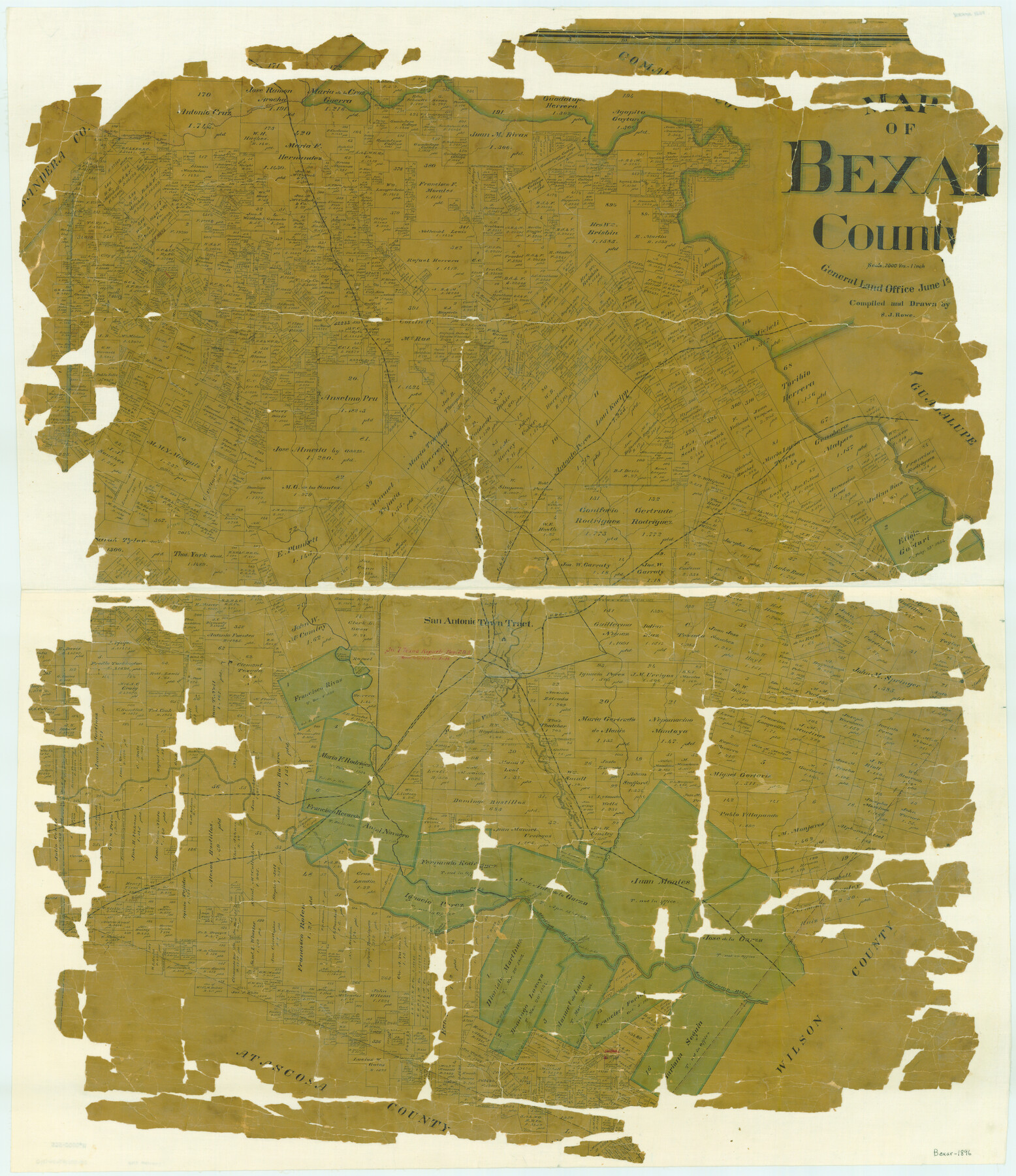
Map of Bexar County
-
Map/Doc
4766
-
Collection
General Map Collection
-
Object Dates
1896/6/1 (Creation Date)
-
People and Organizations
Texas General Land Office (Publisher)
Sidney J. Rowe (Draftsman)
Sidney J. Rowe (Compiler)
-
Counties
Bexar
-
Subjects
County
-
Height x Width
46.2 x 39.9 inches
117.3 x 101.3 cm
-
Comments
Possible date is June 1, 1896.
-
Features
San Antonio Springs
Kerr's Crossing
Leon Creek
Elm Creek
Perez Crossing
Medina River
Lasoyo's Crossing
Calaveras Creek
Leon Spring
Helotes Cr[eek]
Colebra Cr[eek]
L&GRR
Elmendorf
Martinez
GH&SA
San Pedro Springs
San Antonio River
San Pedro Creek
Calavera's Cr[eek]
Salado Cr[eek]
Leon Creek
Elm
Medina River
San Pedro Creek
Paint Road
Cibolo River
Leon Springs
Helotes Creek
Colebra Creek
I&GN
San Antonio Springs
Martinez Creek
GH&SA
San Pedro Springs
I&GN Depot
Balcones Creek
San Antonio River
GH&SA Depot
San Antonio
Mission Concepcíon
Mission San Jose
Mission Espada
Medio Creek
Salado Creek
Chupaderas Creek
Parita Creek
Part of: General Map Collection
Cooke County Sketch File 24

Print $6.00
- Digital $50.00
Cooke County Sketch File 24
1871
Size 10.3 x 8.3 inches
Map/Doc 19272
National Railways of Mexico

Digital $50.00
National Railways of Mexico
1966
Size 8.9 x 17.6 inches
Map/Doc 94189
Montague County Working Sketch 18

Print $20.00
- Digital $50.00
Montague County Working Sketch 18
1948
Size 27.9 x 21.4 inches
Map/Doc 71084
Wichita County Sketch File 1

Print $22.00
- Digital $50.00
Wichita County Sketch File 1
1856
Size 13.5 x 16.8 inches
Map/Doc 40028
Topographical Map of the Rio Grande from Roma to the Gulf of Mexico, Index Map, Sheet No. 2

Print $20.00
- Digital $50.00
Topographical Map of the Rio Grande from Roma to the Gulf of Mexico, Index Map, Sheet No. 2
1912
Map/Doc 89524
Lubbock County Working Sketch 6

Print $20.00
- Digital $50.00
Lubbock County Working Sketch 6
1959
Size 25.1 x 22.4 inches
Map/Doc 70666
Kinney County Rolled Sketch 1

Print $20.00
- Digital $50.00
Kinney County Rolled Sketch 1
Size 25.1 x 36.1 inches
Map/Doc 6533
Flight Mission No. BRA-7M, Frame 16, Jefferson County

Print $20.00
- Digital $50.00
Flight Mission No. BRA-7M, Frame 16, Jefferson County
1953
Size 18.5 x 22.2 inches
Map/Doc 85467
Map of Kerr County

Print $40.00
- Digital $50.00
Map of Kerr County
1895
Size 41.3 x 57.1 inches
Map/Doc 7824
Val Verde County Sketch File 45

Print $20.00
- Digital $50.00
Val Verde County Sketch File 45
1938
Size 21.3 x 16.5 inches
Map/Doc 12586
Rusk County Rolled Sketch 9

Print $20.00
- Digital $50.00
Rusk County Rolled Sketch 9
Size 25.0 x 33.0 inches
Map/Doc 7546
Coryell County Sketch File 4

Print $6.00
- Digital $50.00
Coryell County Sketch File 4
1854
Size 12.8 x 8.2 inches
Map/Doc 19342
You may also like
Right of Way & Track Map, The Texas & Pacific Ry. Co. Main Line

Print $20.00
- Digital $50.00
Right of Way & Track Map, The Texas & Pacific Ry. Co. Main Line
Size 11.0 x 19.0 inches
Map/Doc 64685
[Rockwall County School Land and adjacent Blocks]
![90759, [Rockwall County School Land and adjacent Blocks], Twichell Survey Records](https://historictexasmaps.com/wmedia_w700/maps/90759-1.tif.jpg)
Print $20.00
- Digital $50.00
[Rockwall County School Land and adjacent Blocks]
1904
Size 16.2 x 12.6 inches
Map/Doc 90759

Hood County Sketch File 16

Print $4.00
- Digital $50.00
Hood County Sketch File 16
1860
Size 10.2 x 8.2 inches
Map/Doc 26597
[Sabine County School Land and vicinity]
![90981, [Sabine County School Land and vicinity], Twichell Survey Records](https://historictexasmaps.com/wmedia_w700/maps/90981-1.tif.jpg)
Print $20.00
- Digital $50.00
[Sabine County School Land and vicinity]
Size 18.1 x 19.9 inches
Map/Doc 90981
Presidio County Rolled Sketch 57

Print $20.00
- Digital $50.00
Presidio County Rolled Sketch 57
1915
Size 22.8 x 17.3 inches
Map/Doc 7350
Galveston County Working Sketch 2

Print $20.00
- Digital $50.00
Galveston County Working Sketch 2
1924
Size 24.1 x 26.3 inches
Map/Doc 69339
Travis County Appraisal District Plat Map 2_2814

Print $20.00
- Digital $50.00
Travis County Appraisal District Plat Map 2_2814
Size 21.6 x 26.4 inches
Map/Doc 94218
Live Oak County Sketch File 21

Print $26.00
- Digital $50.00
Live Oak County Sketch File 21
1912
Size 16.8 x 8.0 inches
Map/Doc 30297
San Jacinto County Sketch File 4

Print $4.00
San Jacinto County Sketch File 4
1857
Size 12.9 x 7.9 inches
Map/Doc 35700
Texas Intracoastal Waterway - Laguna Madre - Rincon de San Jose to Chubby Island
Print $20.00
- Digital $50.00
Texas Intracoastal Waterway - Laguna Madre - Rincon de San Jose to Chubby Island
1957
Size 38.9 x 27.3 inches
Map/Doc 73513
Dawson County Sketch File 3a

Print $12.00
- Digital $50.00
Dawson County Sketch File 3a
Size 12.9 x 8.3 inches
Map/Doc 20503