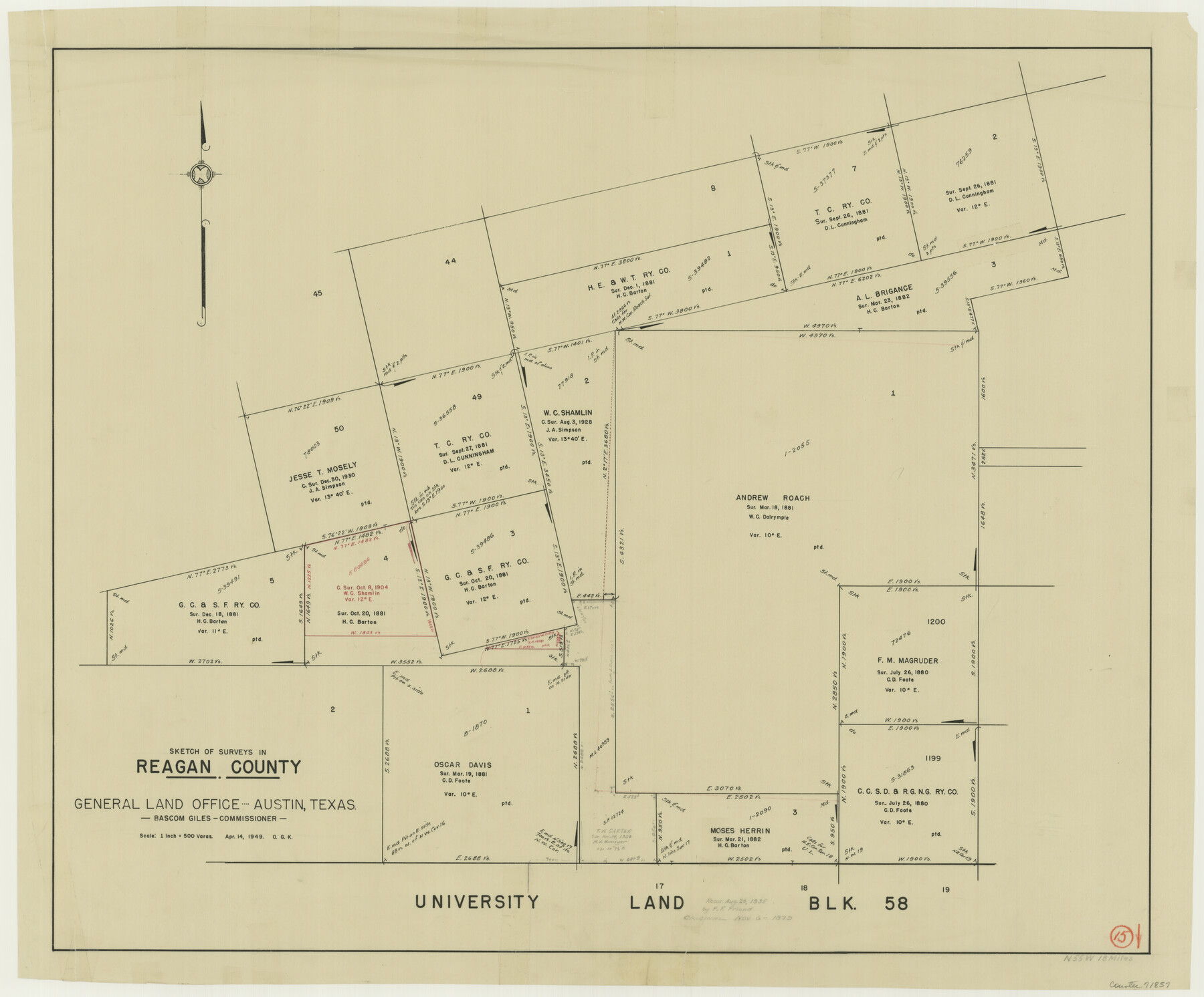
Reagan County Working Sketch 15
-
Map/Doc
71857
-
Collection
General Map Collection
-
Object Dates
4/14/1949 (Creation Date)
-
People and Organizations
Otto G. Kurio (Draftsman)
-
Counties
Reagan
-
Subjects
Surveying Working Sketch
-
Height x Width
27.3 x 33.0 inches
69.3 x 83.8 cm
-
Scale
1" = 500 varas
Part of: General Map Collection
Duval County Sketch File 52

Print $20.00
- Digital $50.00
Duval County Sketch File 52
1936
Size 21.0 x 28.6 inches
Map/Doc 11402
Texas Official Travel Map

Digital $50.00
Texas Official Travel Map
Size 33.5 x 36.2 inches
Map/Doc 94303
Matagorda County Sketch File 7a

Print $8.00
- Digital $50.00
Matagorda County Sketch File 7a
1890
Size 14.2 x 8.9 inches
Map/Doc 30740
Map of Angelina County

Print $20.00
- Digital $50.00
Map of Angelina County
1862
Size 19.1 x 27.0 inches
Map/Doc 3233
Navasota River, Springfield Sheet

Print $20.00
- Digital $50.00
Navasota River, Springfield Sheet
1934
Size 41.5 x 37.8 inches
Map/Doc 65074
Galveston County Sketch File 19

Print $4.00
- Digital $50.00
Galveston County Sketch File 19
Size 9.3 x 7.3 inches
Map/Doc 23390
Houston, (Capital de Tejas)

Print $20.00
- Digital $50.00
Houston, (Capital de Tejas)
1845
Size 6.8 x 10.0 inches
Map/Doc 97238
Hood County Working Sketch 14

Print $20.00
- Digital $50.00
Hood County Working Sketch 14
1980
Size 24.1 x 24.6 inches
Map/Doc 66208
Cottle County Sketch File 7

Print $20.00
- Digital $50.00
Cottle County Sketch File 7
1893
Size 22.1 x 20.7 inches
Map/Doc 11191
[F. W. & D. C. Ry. Co. Alignment and Right of Way Map, Clay County]
![64745, [F. W. & D. C. Ry. Co. Alignment and Right of Way Map, Clay County], General Map Collection](https://historictexasmaps.com/wmedia_w700/maps/64745-GC.tif.jpg)
Print $20.00
- Digital $50.00
[F. W. & D. C. Ry. Co. Alignment and Right of Way Map, Clay County]
1927
Size 18.7 x 11.8 inches
Map/Doc 64745
Anderson County Sketch File 14

Print $4.00
- Digital $50.00
Anderson County Sketch File 14
1857
Size 12.7 x 8.0 inches
Map/Doc 12779
Live Oak County Sketch File 4

Print $20.00
- Digital $50.00
Live Oak County Sketch File 4
1858
Size 16.3 x 19.2 inches
Map/Doc 12006
You may also like
General Highway Map, Bowie County, Texas

Print $20.00
General Highway Map, Bowie County, Texas
1961
Size 18.2 x 25.0 inches
Map/Doc 79380
Parker County Sketch File 15A

Print $20.00
- Digital $50.00
Parker County Sketch File 15A
1875
Size 28.5 x 13.6 inches
Map/Doc 12144
Rockwall County Boundary File 75a

Print $10.00
- Digital $50.00
Rockwall County Boundary File 75a
Size 13.0 x 8.2 inches
Map/Doc 58481
Frio County Working Sketch 11

Print $20.00
- Digital $50.00
Frio County Working Sketch 11
1952
Size 22.9 x 20.0 inches
Map/Doc 69285
Jefferson County Rolled Sketch 49

Print $40.00
- Digital $50.00
Jefferson County Rolled Sketch 49
1963
Size 32.5 x 57.4 inches
Map/Doc 66844
Brewster County Rolled Sketch 60

Print $40.00
- Digital $50.00
Brewster County Rolled Sketch 60
Size 37.1 x 68.9 inches
Map/Doc 8485
Public School Land Field Note Volume Index

Public School Land Field Note Volume Index
2023
Size 8.5 x 11.0 inches
Map/Doc 97176
Panorama of the seat of war - Birds eye view of Texas and part of Mexico

Print $20.00
Panorama of the seat of war - Birds eye view of Texas and part of Mexico
1861
Size 21.6 x 28.9 inches
Map/Doc 93360
Maverick County Working Sketch 1

Print $20.00
- Digital $50.00
Maverick County Working Sketch 1
1906
Size 11.5 x 11.1 inches
Map/Doc 70893
Pecos County Rolled Sketch 171

Print $20.00
- Digital $50.00
Pecos County Rolled Sketch 171
1975
Size 17.3 x 17.0 inches
Map/Doc 7293
Wichita County, State of Texas 1889

Print $20.00
- Digital $50.00
Wichita County, State of Texas 1889
1889
Size 44.3 x 32.6 inches
Map/Doc 89649
Flight Mission No. CUG-3P, Frame 91, Kleberg County

Print $20.00
- Digital $50.00
Flight Mission No. CUG-3P, Frame 91, Kleberg County
1956
Size 18.4 x 22.2 inches
Map/Doc 86261