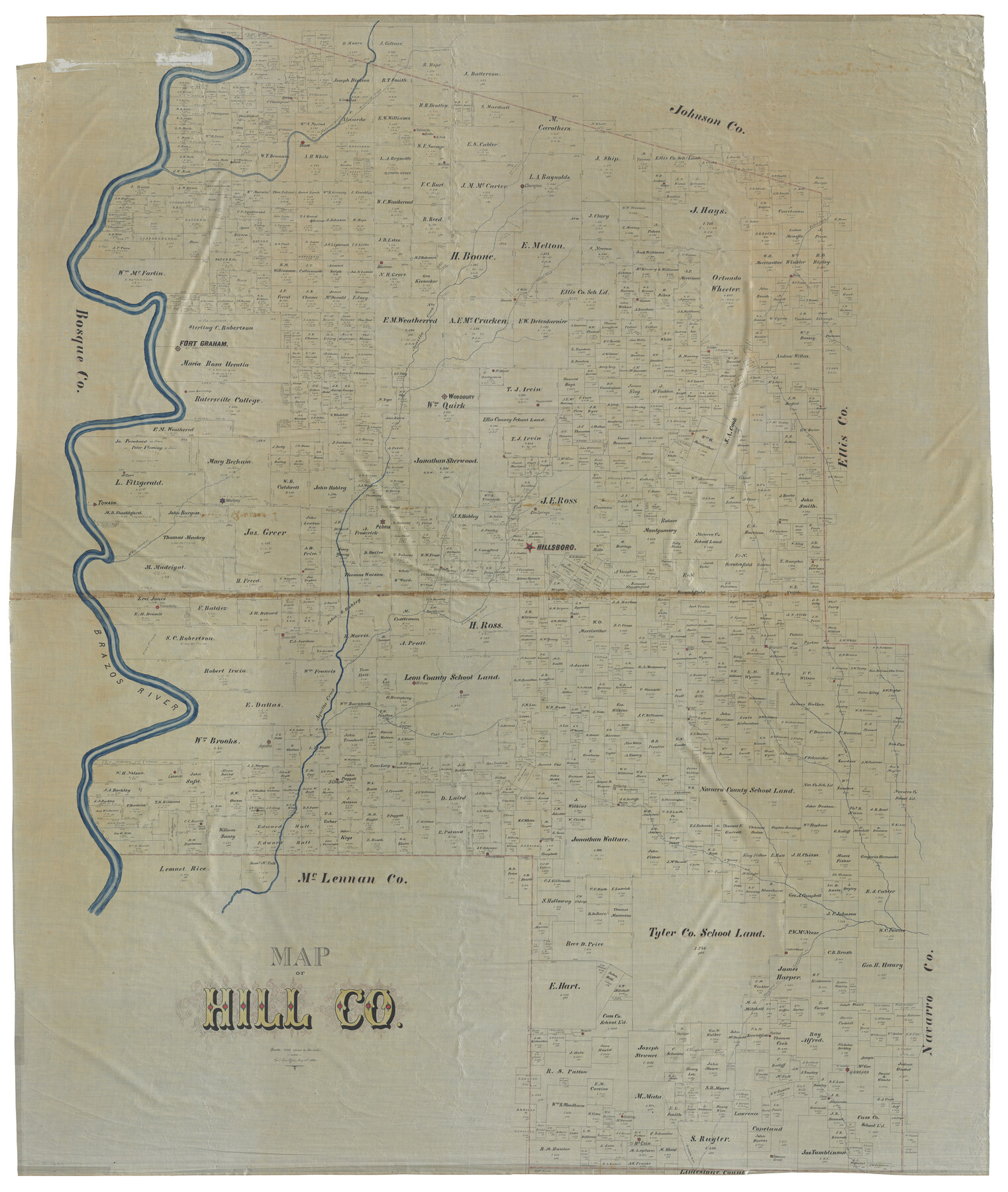
Map of Hill County
-
Map/Doc
82049
-
Collection
General Map Collection
-
Object Dates
5/30/1884 (Creation Date)
-
People and Organizations
Texas General Land Office (Publisher)
-
Counties
Hill
-
Subjects
County
-
Height x Width
80.1 x 68.0 inches
203.5 x 172.7 cm
-
Medium
linen, manuscript
-
Comments
Digital composite. See maps 93378 and 93379 for full-size halves of this map.
Reproductions are printed at 70.5" x 59.8" (88% of actual size).
Related maps
Map of Hill County

Print $40.00
- Digital $50.00
Map of Hill County
1884
Size 80.0 x 36.8 inches
Map/Doc 93378
Map of Hill County

Print $40.00
- Digital $50.00
Map of Hill County
1884
Size 80.0 x 35.2 inches
Map/Doc 93379
Part of: General Map Collection
King County Rolled Sketch 12

Print $20.00
- Digital $50.00
King County Rolled Sketch 12
1955
Size 40.9 x 45.7 inches
Map/Doc 9352
Zavala County Sketch File 10a

Print $6.00
- Digital $50.00
Zavala County Sketch File 10a
1885
Size 14.6 x 8.8 inches
Map/Doc 41267
Houston County Sketch File 44

Print $42.00
- Digital $50.00
Houston County Sketch File 44
1847
Size 8.3 x 12.9 inches
Map/Doc 26834
Jeff Davis County Rolled Sketch 17

Print $20.00
- Digital $50.00
Jeff Davis County Rolled Sketch 17
Size 28.7 x 42.2 inches
Map/Doc 6370
Dawson County Sketch File 10

Print $4.00
- Digital $50.00
Dawson County Sketch File 10
1927
Size 11.4 x 8.8 inches
Map/Doc 20544
Dimmit County Boundary File 6

Print $32.00
- Digital $50.00
Dimmit County Boundary File 6
Size 31.1 x 7.0 inches
Map/Doc 52580
Franklin County Boundary File 1

Print $8.00
- Digital $50.00
Franklin County Boundary File 1
Size 12.9 x 8.1 inches
Map/Doc 53569
Travis County Sketch File 52

Print $8.00
- Digital $50.00
Travis County Sketch File 52
1942
Size 14.4 x 8.9 inches
Map/Doc 38391
Sulphur River, Boxelder Sheet/Cuthand Creek

Print $20.00
- Digital $50.00
Sulphur River, Boxelder Sheet/Cuthand Creek
1922
Size 29.5 x 25.1 inches
Map/Doc 65156
Culberson County Working Sketch 32

Print $20.00
- Digital $50.00
Culberson County Working Sketch 32
1958
Size 45.3 x 38.0 inches
Map/Doc 68485
Karnes County Working Sketch 2

Print $20.00
- Digital $50.00
Karnes County Working Sketch 2
1939
Size 18.8 x 20.0 inches
Map/Doc 66650
Lynn County Sketch File 20

Print $4.00
- Digital $50.00
Lynn County Sketch File 20
1891
Size 8.8 x 10.9 inches
Map/Doc 30527
You may also like
Coleman County Working Sketch 11
Print $20.00
- Digital $50.00
Coleman County Working Sketch 11
1950
Size 24.2 x 18.2 inches
Map/Doc 68077
Central America II. Including Texas, California and the Northern States of Mexico

Print $20.00
- Digital $50.00
Central America II. Including Texas, California and the Northern States of Mexico
Size 14.1 x 16.7 inches
Map/Doc 93927
[Aerial photograph from Carancahua Bend of Caney Creek to Cedar Lake]
![78640, [Aerial photograph from Carancahua Bend of Caney Creek to Cedar Lake], General Map Collection](https://historictexasmaps.com/wmedia_w700/maps/78640.tif.jpg)
Print $20.00
- Digital $50.00
[Aerial photograph from Carancahua Bend of Caney Creek to Cedar Lake]
1991
Size 24.4 x 30.3 inches
Map/Doc 78640
Carta Particular de las Costas Setentrionales del Seno Mexicano que comprehende las de la Florida Ocidental las Margenes de la Luisiana y toda la rivera que sigue por la Bahía de San Bernardo y el Río Bravo del Norte hasta la Laguna Madre

Carta Particular de las Costas Setentrionales del Seno Mexicano que comprehende las de la Florida Ocidental las Margenes de la Luisiana y toda la rivera que sigue por la Bahía de San Bernardo y el Río Bravo del Norte hasta la Laguna Madre
1825
Size 26.1 x 38.7 inches
Map/Doc 94568
Presidio County Working Sketch 105

Print $20.00
- Digital $50.00
Presidio County Working Sketch 105
1980
Size 27.5 x 27.5 inches
Map/Doc 71782
Sketch Showing Boundary Between Randall and Deaf Smith Counties

Print $20.00
- Digital $50.00
Sketch Showing Boundary Between Randall and Deaf Smith Counties
Size 13.4 x 33.3 inches
Map/Doc 91832
Pecos County Sketch File 89

Print $40.00
- Digital $50.00
Pecos County Sketch File 89
1949
Size 15.2 x 12.2 inches
Map/Doc 33986

Runnels County Working Sketch 26

Print $20.00
- Digital $50.00
Runnels County Working Sketch 26
1956
Size 17.3 x 13.6 inches
Map/Doc 63622
Hunt County Working Sketch 1

Print $20.00
- Digital $50.00
Hunt County Working Sketch 1
Size 18.2 x 17.2 inches
Map/Doc 66348

Plano General de la Ciudad de Mexico. Levantado Por el Teniente Coronel Don Diego Garcia Conde en el Año de 1793. Aumentado y corregido en lo mas notable Por el Teniente Coronel retirado, Don Rafael Maria Calvo En el de 1830

Print $20.00
- Digital $50.00
Plano General de la Ciudad de Mexico. Levantado Por el Teniente Coronel Don Diego Garcia Conde en el Año de 1793. Aumentado y corregido en lo mas notable Por el Teniente Coronel retirado, Don Rafael Maria Calvo En el de 1830
1793
Size 19.7 x 21.8 inches
Map/Doc 95354