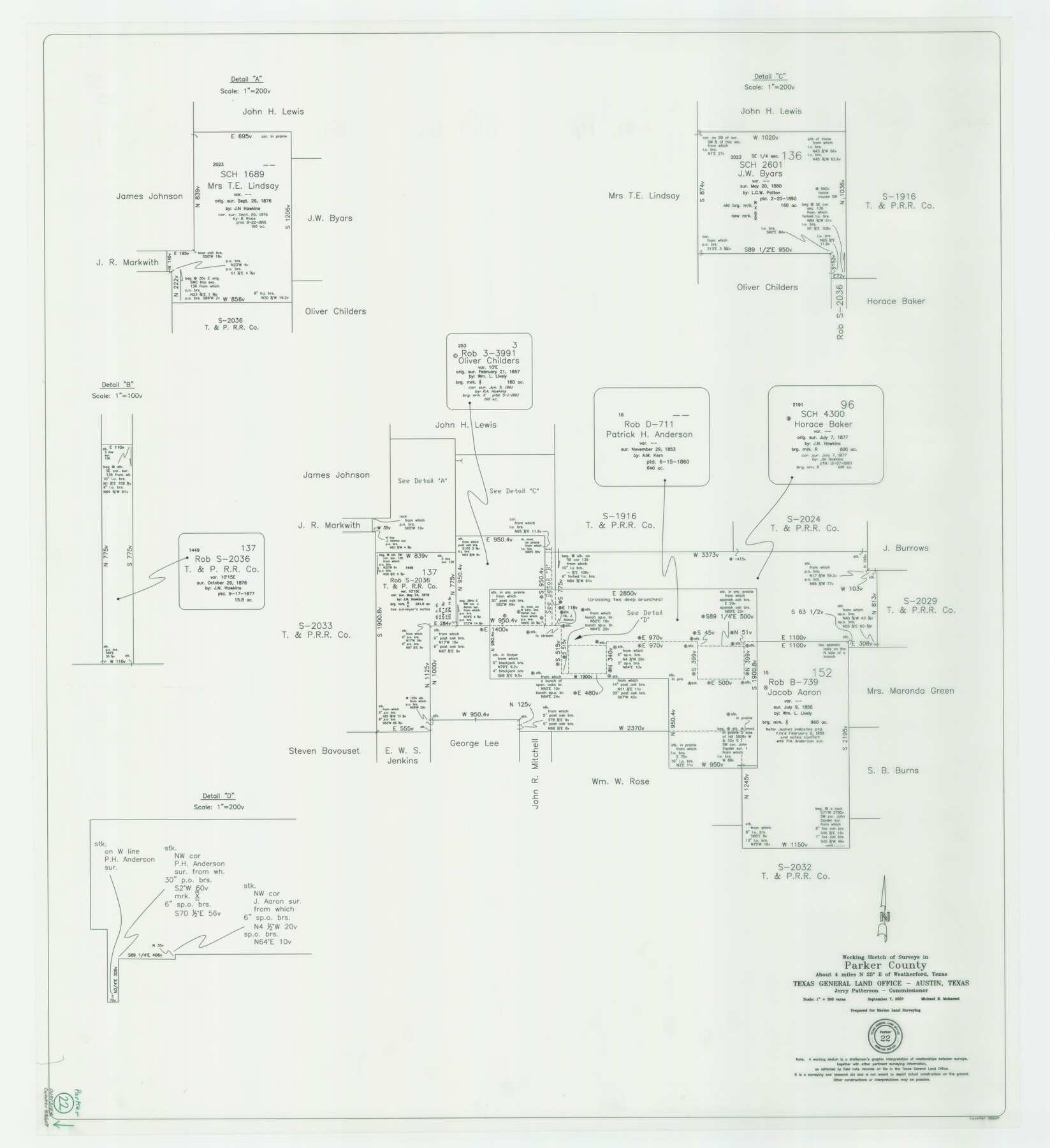
Parker County Working Sketch 22
-
Map/Doc
88607
-
Collection
General Map Collection
-
Object Dates
9/7/2007 (Creation Date)
-
People and Organizations
Jerry E. Patterson (GLO Commissioner)
Michael R. Mokarzel (Draftsman)
-
Counties
Parker
-
Subjects
Surveying Working Sketch
-
Scale
1" = 300 varas
Part of: General Map Collection
Jefferson County Working Sketch 32

Print $40.00
- Digital $50.00
Jefferson County Working Sketch 32
1981
Size 68.9 x 36.0 inches
Map/Doc 66576
San Patricio County Aerial Photograph Index Sheet 5

Print $20.00
- Digital $50.00
San Patricio County Aerial Photograph Index Sheet 5
1957
Size 23.9 x 19.2 inches
Map/Doc 83747
McLennan County Sketch File 6

Print $4.00
- Digital $50.00
McLennan County Sketch File 6
1850
Size 7.2 x 7.9 inches
Map/Doc 31244
Flight Mission No. CRC-3R, Frame 164, Chambers County

Print $20.00
- Digital $50.00
Flight Mission No. CRC-3R, Frame 164, Chambers County
1956
Size 18.7 x 22.3 inches
Map/Doc 84846
Outer Continental Shelf Leasing Maps (Texas Offshore Operations)

Print $20.00
- Digital $50.00
Outer Continental Shelf Leasing Maps (Texas Offshore Operations)
Size 19.4 x 18.5 inches
Map/Doc 75849
El Paso County Working Sketch 18

Print $40.00
- Digital $50.00
El Paso County Working Sketch 18
1960
Size 74.4 x 16.1 inches
Map/Doc 69040
Hutchinson County

Print $20.00
- Digital $50.00
Hutchinson County
1922
Size 45.4 x 37.6 inches
Map/Doc 95538
Northwest Part Pecos County

Print $20.00
- Digital $50.00
Northwest Part Pecos County
1975
Size 43.4 x 44.2 inches
Map/Doc 95612
Tyler County Sketch File 6a

Print $4.00
- Digital $50.00
Tyler County Sketch File 6a
Size 10.1 x 8.0 inches
Map/Doc 38635
Duval County Sketch File 67

Print $16.00
- Digital $50.00
Duval County Sketch File 67
1949
Size 14.2 x 8.8 inches
Map/Doc 21448
Travis County Rolled Sketch 42

Print $20.00
- Digital $50.00
Travis County Rolled Sketch 42
Size 25.2 x 25.7 inches
Map/Doc 8040

You may also like
Brazos River, Brazos River Sheet 1

Print $4.00
- Digital $50.00
Brazos River, Brazos River Sheet 1
1926
Size 21.5 x 25.4 inches
Map/Doc 65293
Right of Way and Track Map, Houston & Texas Central R.R. operated by the T. and N. O. R.R., Fort Worth Branch

Print $40.00
- Digital $50.00
Right of Way and Track Map, Houston & Texas Central R.R. operated by the T. and N. O. R.R., Fort Worth Branch
1918
Size 31.6 x 57.2 inches
Map/Doc 64780
Intracoastal Waterway in Texas - Corpus Christi to Point Isabel including Arroyo Colorado to Mo. Pac. R.R. Bridge Near Harlingen

Print $20.00
- Digital $50.00
Intracoastal Waterway in Texas - Corpus Christi to Point Isabel including Arroyo Colorado to Mo. Pac. R.R. Bridge Near Harlingen
1933
Size 28.0 x 41.0 inches
Map/Doc 61875
Map of South America engraved to illustrate Mitchell's new intermediate geography

Print $20.00
- Digital $50.00
Map of South America engraved to illustrate Mitchell's new intermediate geography
1885
Size 12.2 x 9.0 inches
Map/Doc 93525
Culberson County Working Sketch 46

Print $20.00
- Digital $50.00
Culberson County Working Sketch 46
1971
Size 25.9 x 37.4 inches
Map/Doc 68500
Kinney County Working Sketch 25

Print $20.00
- Digital $50.00
Kinney County Working Sketch 25
1952
Size 30.9 x 32.9 inches
Map/Doc 70207
South Part Presidio County

Print $20.00
- Digital $50.00
South Part Presidio County
1975
Size 35.0 x 40.3 inches
Map/Doc 95617
Bastrop County

Print $40.00
- Digital $50.00
Bastrop County
1917
Size 48.0 x 40.5 inches
Map/Doc 4881
A sketch of the map of the Land Dist. of Liberty

Print $2.00
- Digital $50.00
A sketch of the map of the Land Dist. of Liberty
Size 6.3 x 3.9 inches
Map/Doc 353
Houston County Working Sketch 13

Print $20.00
- Digital $50.00
Houston County Working Sketch 13
1956
Size 39.3 x 39.6 inches
Map/Doc 66243
Map of Re-Survey of Blk. 34 & 35 T5N

Print $40.00
- Digital $50.00
Map of Re-Survey of Blk. 34 & 35 T5N
1915
Size 53.5 x 39.2 inches
Map/Doc 89765
Colorado County Working Sketch 6

Print $20.00
- Digital $50.00
Colorado County Working Sketch 6
1921
Size 15.4 x 14.3 inches
Map/Doc 68106