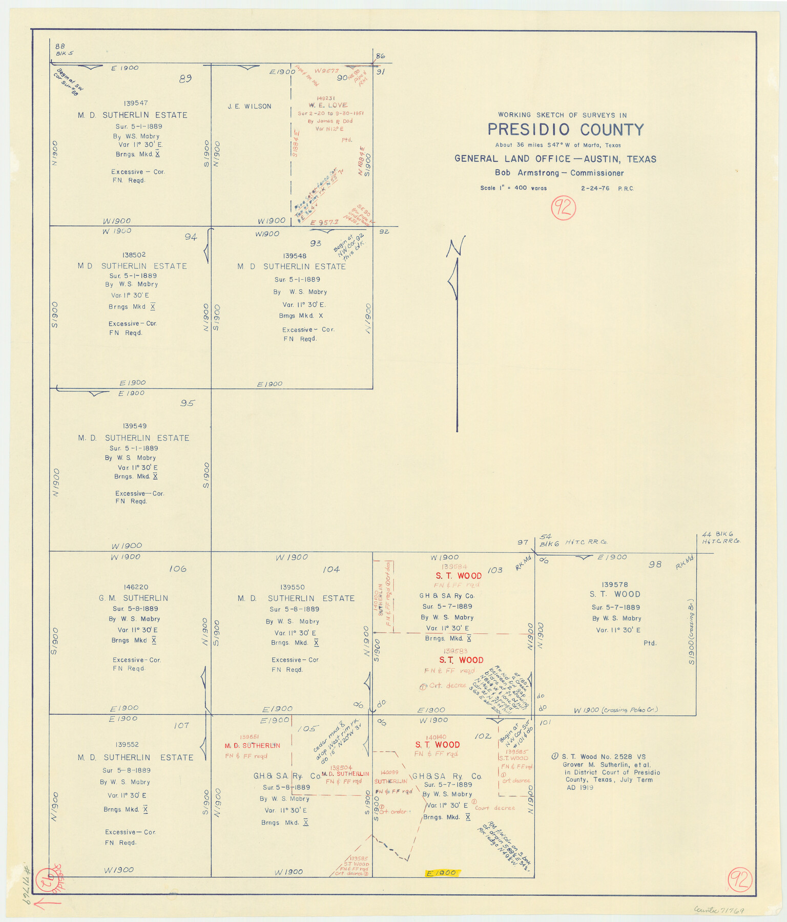
Presidio County Working Sketch 92
- 
                          Map/Doc
71769
 - 
                            Collection
General Map Collection
 - 
                            Object Dates
2/24/1976 (Creation Date)
 - 
                            People and Organizations
Preston R. Connelly (Draftsman)
 - 
                            Counties
Presidio
 - 
                            Subjects
Surveying Working Sketch
 - 
                            Height x Width
27.1 x 23.1 inches
68.8 x 58.7 cm
 - 
                            Scale
1" = 400 varas
 
Part of: General Map Collection
            Coleman County Sketch File 19


                                            Print $4.00                    
                                             -                         Digital $50.00                                    
                Coleman County Sketch File 19
Size 12.5 x 8.1 inches
                                Map/Doc 18692
            
            Flight Mission No. BRA-7M, Frame 17, Jefferson County


                                            Print $20.00                    
                                             -                         Digital $50.00                                    
                Flight Mission No. BRA-7M, Frame 17, Jefferson County
1953
Size 18.6 x 22.4 inches
                                Map/Doc 85468
            
            Garza County Rolled Sketch 11


                                            Print $20.00                    
                                             -                         Digital $50.00                                    
                Garza County Rolled Sketch 11
1915
Size 31.6 x 20.8 inches
                                Map/Doc 6000
            
            Surveys on the lines [?] of Plum Creek


                                            Print $2.00                    
                                             -                         Digital $50.00                                    
                Surveys on the lines [?] of Plum Creek
Size 10.5 x 8.4 inches
                                Map/Doc 78384
            
            [Ft. W. & R. G. Ry. Right of Way Map, Chapin to Bluffdale, Hood County, Texas]


                                            Print $40.00                    
                                             -                         Digital $50.00                                    
                [Ft. W. & R. G. Ry. Right of Way Map, Chapin to Bluffdale, Hood County, Texas]
1918
Size 36.8 x 69.7 inches
                                Map/Doc 64646
            
            Crockett County Working Sketch 56


                                            Print $20.00                    
                                             -                         Digital $50.00                                    
                Crockett County Working Sketch 56
1947
Size 28.5 x 46.7 inches
                                Map/Doc 68389
            
            Reeves County Rolled Sketch 40


                                            Print $20.00                    
                                             -                         Digital $50.00                                    
                Reeves County Rolled Sketch 40
2019
Size 18.1 x 24.2 inches
                                Map/Doc 95826
            
            Real County Rolled Sketch 1


                                            Print $20.00                    
                                             -                         Digital $50.00                                    
                Real County Rolled Sketch 1
1941
Size 20.6 x 28.9 inches
                                Map/Doc 7452
            
            Armstrong County Boundary File 4


                                            Print $2.00                    
                                             -                         Digital $50.00                                    
                Armstrong County Boundary File 4
Size 10.2 x 8.8 inches
                                Map/Doc 50148
            
            Liberty County Working Sketch 19


                                            Print $20.00                    
                                             -                         Digital $50.00                                    
                Liberty County Working Sketch 19
1940
Size 29.2 x 41.3 inches
                                Map/Doc 70478
            
            Austin County Sketch File 9


                                            Print $66.00                    
                                             -                         Digital $50.00                                    
                Austin County Sketch File 9
1895
Size 22.9 x 36.5 inches
                                Map/Doc 10874
            
            Kent County Sketch File 10


                                            Print $42.00                    
                                             -                         Digital $50.00                                    
                Kent County Sketch File 10
1924
Size 22.1 x 35.5 inches
                                Map/Doc 11914
            You may also like
            Stephens County Working Sketch 32


                                            Print $20.00                    
                                             -                         Digital $50.00                                    
                Stephens County Working Sketch 32
1978
Size 30.9 x 28.7 inches
                                Map/Doc 63975
            
            Orange County Sketch File 41


                                            Print $40.00                    
                                             -                         Digital $50.00                                    
                Orange County Sketch File 41
1918
Size 13.2 x 13.3 inches
                                Map/Doc 33381
            
            Borden County Working Sketch of Geo. Spiller's Resurvey of Block 97 made in 1887


                                            Print $3.00                    
                                             -                         Digital $50.00                                    
                Borden County Working Sketch of Geo. Spiller's Resurvey of Block 97 made in 1887
1903
Size 10.1 x 16.6 inches
                                Map/Doc 90211
            
            Map of Fayette County


                                            Print $20.00                    
                                             -                         Digital $50.00                                    
                Map of Fayette County
1871
Size 19.2 x 22.0 inches
                                Map/Doc 3538
            
            Hemphill County Sketch File 10


                                            Print $6.00                    
                                             -                         Digital $50.00                                    
                Hemphill County Sketch File 10
1903
Size 14.3 x 8.8 inches
                                Map/Doc 26315
            
            Boundary Between U.S. - Mexico, 1853


                                            Print $20.00                    
                                             -                         Digital $50.00                                    
                Boundary Between U.S. - Mexico, 1853
1954
Size 24.3 x 18.4 inches
                                Map/Doc 65416
            
            McMullen County Rolled Sketch 10


                                            Print $20.00                    
                                             -                         Digital $50.00                                    
                McMullen County Rolled Sketch 10
1942
Size 24.0 x 19.9 inches
                                Map/Doc 6727
            
            Leon County Working Sketch 1


                                            Print $20.00                    
                                             -                         Digital $50.00                                    
                Leon County Working Sketch 1
Size 16.1 x 18.7 inches
                                Map/Doc 70400
            
            Flight Mission No. CLL-1N, Frame 76, Willacy County


                                            Print $20.00                    
                                             -                         Digital $50.00                                    
                Flight Mission No. CLL-1N, Frame 76, Willacy County
1954
Size 18.3 x 22.0 inches
                                Map/Doc 87022
            
            Panola County Sketch File 16


                                            Print $4.00                    
                                             -                         Digital $50.00                                    
                Panola County Sketch File 16
1882
Size 6.4 x 8.8 inches
                                Map/Doc 33476
            
            Flight Mission No. BQR-7K, Frame 24, Brazoria County


                                            Print $20.00                    
                                             -                         Digital $50.00                                    
                Flight Mission No. BQR-7K, Frame 24, Brazoria County
1952
Size 18.6 x 22.2 inches
                                Map/Doc 84022
            
            [H. & T. C. Block 47 and Vicinity]


                                            Print $20.00                    
                                             -                         Digital $50.00                                    
                [H. & T. C. Block 47 and Vicinity]
1887
Size 16.3 x 18.8 inches
                                Map/Doc 91423