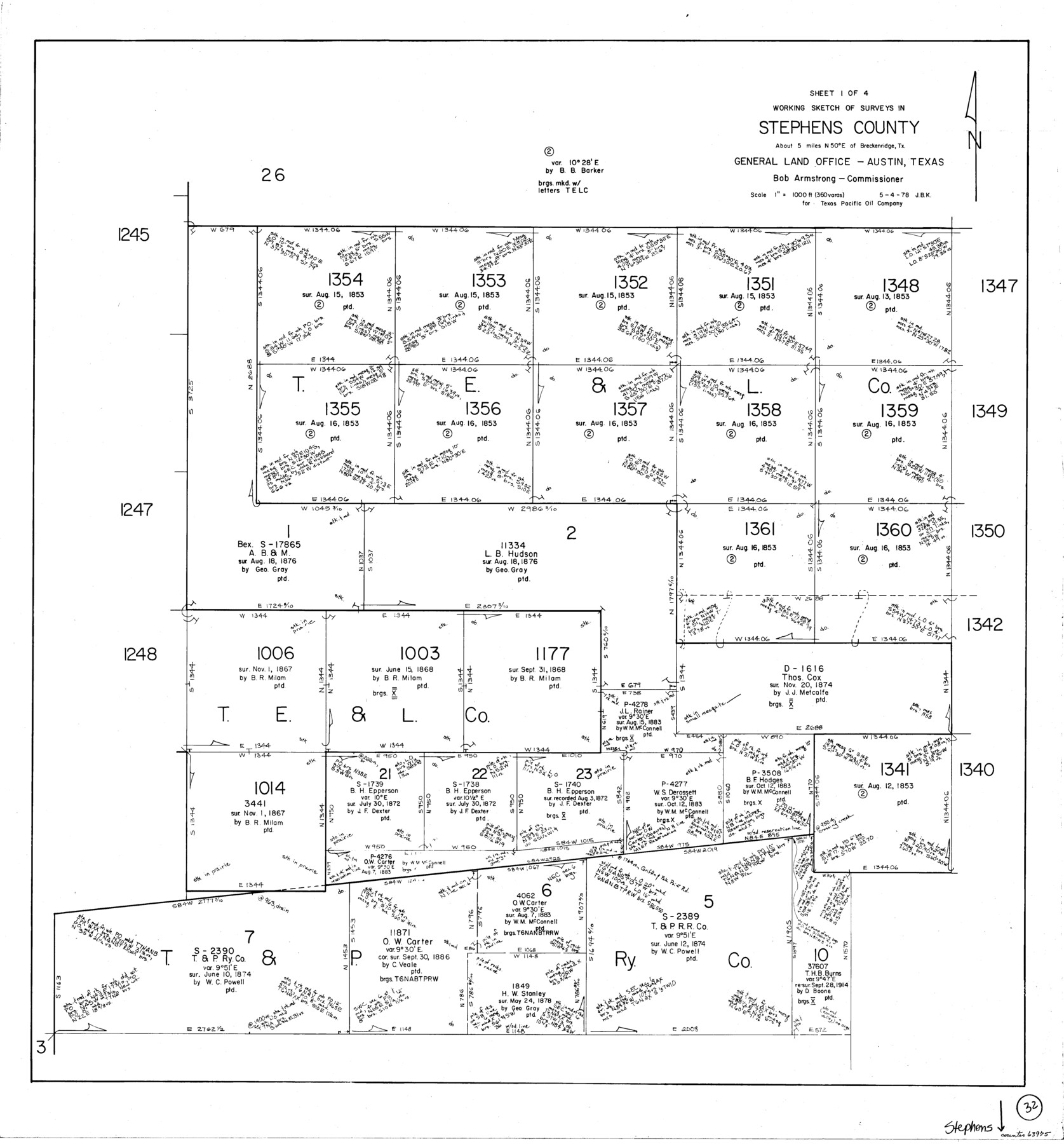
Stephens County Working Sketch 32
-
Map/Doc
63975
-
Collection
General Map Collection
-
Object Dates
5/4/1978 (Creation Date)
-
People and Organizations
Joan Kilpatrick (Draftsman)
-
Counties
Stephens
-
Subjects
Surveying Working Sketch
-
Height x Width
30.9 x 28.7 inches
78.5 x 72.9 cm
-
Scale
1" = 360 varas
Part of: General Map Collection
Wise County Sketch File 23

Print $4.00
- Digital $50.00
Wise County Sketch File 23
1859
Size 7.9 x 12.9 inches
Map/Doc 40568
Flight Mission No. DIX-10P, Frame 76, Aransas County

Print $20.00
- Digital $50.00
Flight Mission No. DIX-10P, Frame 76, Aransas County
1956
Size 18.8 x 22.4 inches
Map/Doc 83937
Jackson County Rolled Sketch 6

Print $20.00
- Digital $50.00
Jackson County Rolled Sketch 6
1914
Size 23.6 x 26.6 inches
Map/Doc 6341
Cameron County Rolled Sketch 20E

Print $20.00
- Digital $50.00
Cameron County Rolled Sketch 20E
Size 12.9 x 11.4 inches
Map/Doc 5479
Newton County Working Sketch 6

Print $20.00
- Digital $50.00
Newton County Working Sketch 6
1930
Size 35.5 x 25.9 inches
Map/Doc 71252
Rusk County Working Sketch 37b

Print $40.00
- Digital $50.00
Rusk County Working Sketch 37b
2007
Size 50.0 x 31.0 inches
Map/Doc 87497
Map of Hill County

Print $40.00
- Digital $50.00
Map of Hill County
1884
Size 80.0 x 36.8 inches
Map/Doc 93378

Matagorda Bay and Approaches

Print $20.00
- Digital $50.00
Matagorda Bay and Approaches
1961
Size 35.0 x 45.0 inches
Map/Doc 73382
Points of Interest & Road Map of Scenicland, U.S.A. and United States [Recto]
![94192, Points of Interest & Road Map of Scenicland, U.S.A. and United States [Recto], General Map Collection](https://historictexasmaps.com/wmedia_w700/maps/94192.tif.jpg)
Points of Interest & Road Map of Scenicland, U.S.A. and United States [Recto]
1966
Size 34.7 x 22.4 inches
Map/Doc 94192
Right of Way and Track Map International & Gt Northern Ry. operated by the International & Gt. Northern Ry. Co., San Antonio Division

Print $40.00
- Digital $50.00
Right of Way and Track Map International & Gt Northern Ry. operated by the International & Gt. Northern Ry. Co., San Antonio Division
1917
Size 25.9 x 57.5 inches
Map/Doc 64588
Public Land on Mustang Island, Nueces County

Print $20.00
- Digital $50.00
Public Land on Mustang Island, Nueces County
1910
Size 17.0 x 17.5 inches
Map/Doc 1997
You may also like
Shelby County Working Sketch 2

Print $20.00
- Digital $50.00
Shelby County Working Sketch 2
Size 32.9 x 37.3 inches
Map/Doc 63855
Kinney County Boundary File 1a

Print $73.00
- Digital $50.00
Kinney County Boundary File 1a
Size 8.5 x 43.2 inches
Map/Doc 64946
Map of Taylor, Bastrop & Houston Railroad in Austin County

Print $20.00
- Digital $50.00
Map of Taylor, Bastrop & Houston Railroad in Austin County
Size 14.6 x 25.1 inches
Map/Doc 64480
Hemphill County Sketch File 2

Print $8.00
- Digital $50.00
Hemphill County Sketch File 2
1900
Size 10.3 x 8.4 inches
Map/Doc 26281
Caldwell County Sketch File 2

Print $40.00
- Digital $50.00
Caldwell County Sketch File 2
1877
Size 12.9 x 20.0 inches
Map/Doc 11030
English Field Notes of the Spanish Archives - Books TJG, DB, A, A2, B, B2, WB, and WR

English Field Notes of the Spanish Archives - Books TJG, DB, A, A2, B, B2, WB, and WR
1835
Map/Doc 96553
Briscoe County Working Sketch 5

Print $20.00
- Digital $50.00
Briscoe County Working Sketch 5
1934
Size 36.7 x 43.0 inches
Map/Doc 67808
Webb County Working Sketch 58

Print $20.00
- Digital $50.00
Webb County Working Sketch 58
1958
Size 37.4 x 37.0 inches
Map/Doc 72424
Hutchinson County Rolled Sketch 28

Print $20.00
- Digital $50.00
Hutchinson County Rolled Sketch 28
1921
Size 28.1 x 34.7 inches
Map/Doc 6290
Duval County Working Sketch 3

Print $40.00
- Digital $50.00
Duval County Working Sketch 3
1925
Size 59.1 x 45.0 inches
Map/Doc 76444
Culberson County Working Sketch 40

Print $40.00
- Digital $50.00
Culberson County Working Sketch 40
1966
Size 35.5 x 60.9 inches
Map/Doc 68493
Crockett County Working Sketch 25

Print $20.00
- Digital $50.00
Crockett County Working Sketch 25
1921
Size 23.5 x 17.6 inches
Map/Doc 68358