Nueces County Rolled Sketch GT
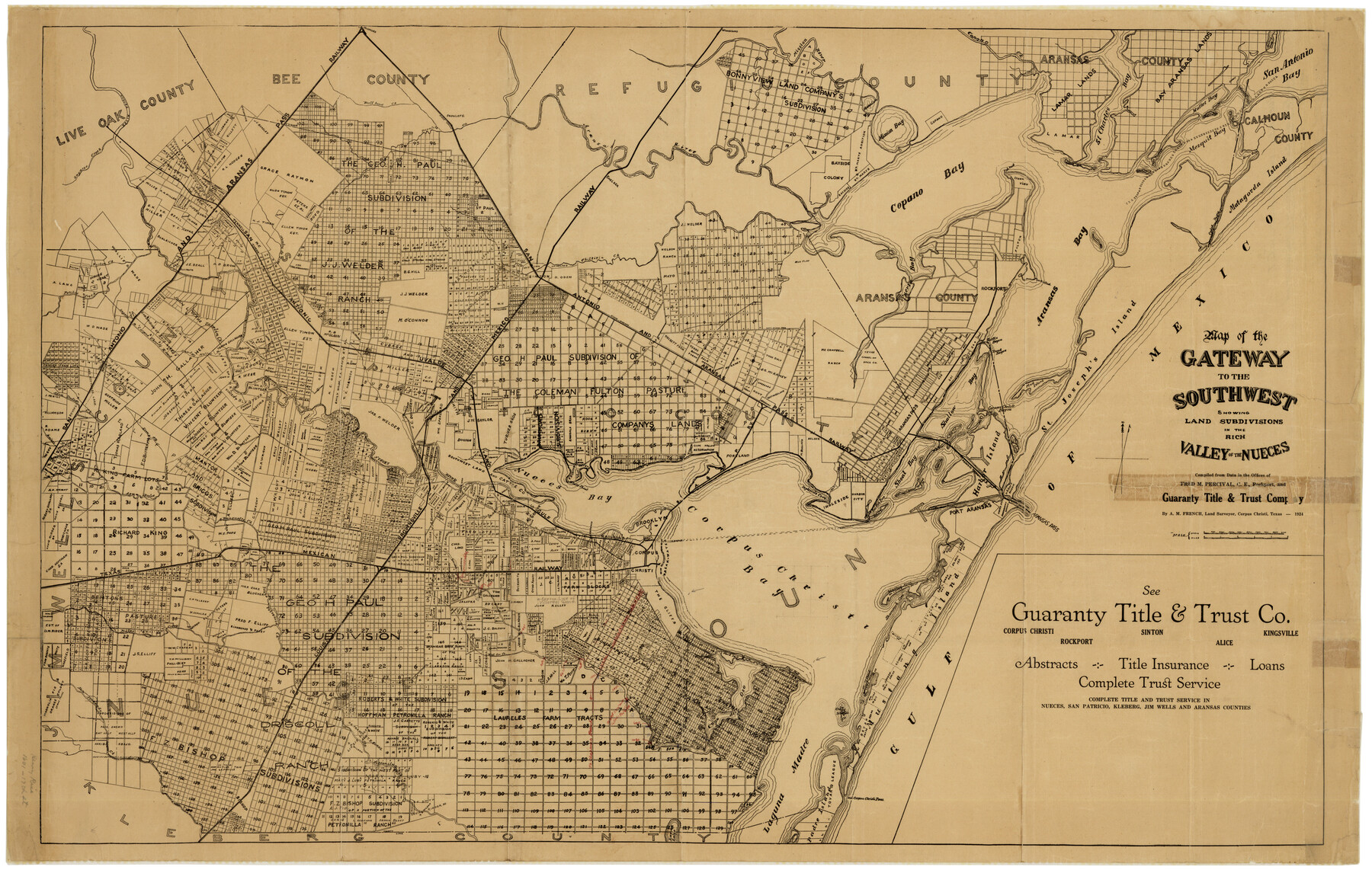
Map of the Gateway to the Southwest showing land subdivisions in the rich Valley of the Nueces
-
Map/Doc
7169
-
Collection
General Map Collection
-
Object Dates
1924 (Creation Date)
9/5/1935 (File Date)
-
People and Organizations
A.M. French (Surveyor/Engineer)
Fred M. Percival (Surveyor/Engineer)
A.M. French (Compiler)
-
Counties
Nueces Live Oak Bee Refugio Aransas Calhoun
-
Subjects
Surveying Rolled Sketch
-
Height x Width
24.9 x 38.6 inches
63.3 x 98.0 cm
-
Medium
paper, etching/engraving/lithograph
-
Comments
See Nueces County Sketch File 41 (32629) for report.
Related maps
Nueces County Sketch File 41

Print $8.00
- Digital $50.00
Nueces County Sketch File 41
Size 11.1 x 8.6 inches
Map/Doc 32629
Part of: General Map Collection
[Gulf, Colorado & Santa Fe Railway line through Fort Bend Co.]
![64212, [Gulf, Colorado & Santa Fe Railway line through Fort Bend Co.], General Map Collection](https://historictexasmaps.com/wmedia_w700/maps/64212.tif.jpg)
Print $20.00
- Digital $50.00
[Gulf, Colorado & Santa Fe Railway line through Fort Bend Co.]
1898
Size 14.2 x 33.5 inches
Map/Doc 64212
[Sketch for Mineral Application 27670 - Strip between Simon Sanchez leagues and Trinity River]
![2865, [Sketch for Mineral Application 27670 - Strip between Simon Sanchez leagues and Trinity River], General Map Collection](https://historictexasmaps.com/wmedia_w700/maps/2865-1.tif.jpg)
Print $40.00
- Digital $50.00
[Sketch for Mineral Application 27670 - Strip between Simon Sanchez leagues and Trinity River]
1934
Size 17.3 x 50.5 inches
Map/Doc 2865
University of Texas Land Survey Isogonic Chart and Graph of Meridian Changes on University Lands Principally in Andrews County, Texas

Print $20.00
- Digital $50.00
University of Texas Land Survey Isogonic Chart and Graph of Meridian Changes on University Lands Principally in Andrews County, Texas
Size 15.0 x 18.4 inches
Map/Doc 62947
Flight Mission No. BRA-3M, Frame 197, Jefferson County

Print $20.00
- Digital $50.00
Flight Mission No. BRA-3M, Frame 197, Jefferson County
1953
Size 18.6 x 22.4 inches
Map/Doc 85412
Edwards County Working Sketch 15

Print $20.00
- Digital $50.00
Edwards County Working Sketch 15
1927
Size 30.0 x 28.4 inches
Map/Doc 68891
Liberty County Working Sketch 32

Print $20.00
- Digital $50.00
Liberty County Working Sketch 32
1945
Size 29.1 x 46.3 inches
Map/Doc 70491
Rio Grande Rectification Project, El Paso and Juarez Valley

Print $20.00
- Digital $50.00
Rio Grande Rectification Project, El Paso and Juarez Valley
1935
Size 10.9 x 29.7 inches
Map/Doc 60860

Maverick County Sketch File 27

Print $6.00
- Digital $50.00
Maverick County Sketch File 27
1873
Size 9.9 x 8.0 inches
Map/Doc 31160
Flight Mission No. DIX-8P, Frame 57, Aransas County

Print $20.00
- Digital $50.00
Flight Mission No. DIX-8P, Frame 57, Aransas County
1956
Size 18.7 x 22.4 inches
Map/Doc 83888
Goliad County Sketch File 9

Print $6.00
- Digital $50.00
Goliad County Sketch File 9
1849
Size 8.1 x 10.1 inches
Map/Doc 24223
West Part Presidio Co.

Print $20.00
- Digital $50.00
West Part Presidio Co.
1974
Size 43.2 x 34.3 inches
Map/Doc 95618
You may also like
Colorado River, Taiton Sheet

Print $6.00
- Digital $50.00
Colorado River, Taiton Sheet
1941
Size 24.4 x 32.8 inches
Map/Doc 65311
Brewster County Rolled Sketch 116

Print $40.00
- Digital $50.00
Brewster County Rolled Sketch 116
1957
Size 13.3 x 51.2 inches
Map/Doc 5293
Flight Mission No. DQN-1K, Frame 41, Calhoun County

Print $20.00
- Digital $50.00
Flight Mission No. DQN-1K, Frame 41, Calhoun County
1953
Size 18.5 x 22.2 inches
Map/Doc 84141
Flight Mission No. DIX-5P, Frame 104, Aransas County

Print $20.00
- Digital $50.00
Flight Mission No. DIX-5P, Frame 104, Aransas County
1956
Size 17.8 x 18.5 inches
Map/Doc 83782
Flight Mission No. DAH-17M, Frame 18, Orange County

Print $20.00
- Digital $50.00
Flight Mission No. DAH-17M, Frame 18, Orange County
1953
Size 18.5 x 22.6 inches
Map/Doc 86881
Martin County Sketch File 15

Print $4.00
- Digital $50.00
Martin County Sketch File 15
Size 11.9 x 8.3 inches
Map/Doc 30674
Duval County Sketch File 38

Print $64.00
- Digital $50.00
Duval County Sketch File 38
Size 38.2 x 19.5 inches
Map/Doc 10372
Railroad Track Map, H&TCRRCo., Falls County, Texas

Print $4.00
- Digital $50.00
Railroad Track Map, H&TCRRCo., Falls County, Texas
1918
Size 11.6 x 18.6 inches
Map/Doc 62834
[Bastrop District]
![83519, [Bastrop District], General Map Collection](https://historictexasmaps.com/wmedia_w700/maps/83519-1.tif.jpg)
Print $20.00
- Digital $50.00
[Bastrop District]
1838
Size 26.5 x 44.2 inches
Map/Doc 83519
Jim Hogg County Working Sketch 2

Print $20.00
- Digital $50.00
Jim Hogg County Working Sketch 2
1933
Size 41.2 x 29.3 inches
Map/Doc 66588
Pecos County Rolled Sketch 146C

Print $20.00
- Digital $50.00
Pecos County Rolled Sketch 146C
Size 43.1 x 39.5 inches
Map/Doc 9743
[T. & N. O. RR. Block 1T]
![91902, [T. & N. O. RR. Block 1T], Twichell Survey Records](https://historictexasmaps.com/wmedia_w700/maps/91902-1.tif.jpg)
Print $20.00
- Digital $50.00
[T. & N. O. RR. Block 1T]
Size 14.9 x 20.0 inches
Map/Doc 91902