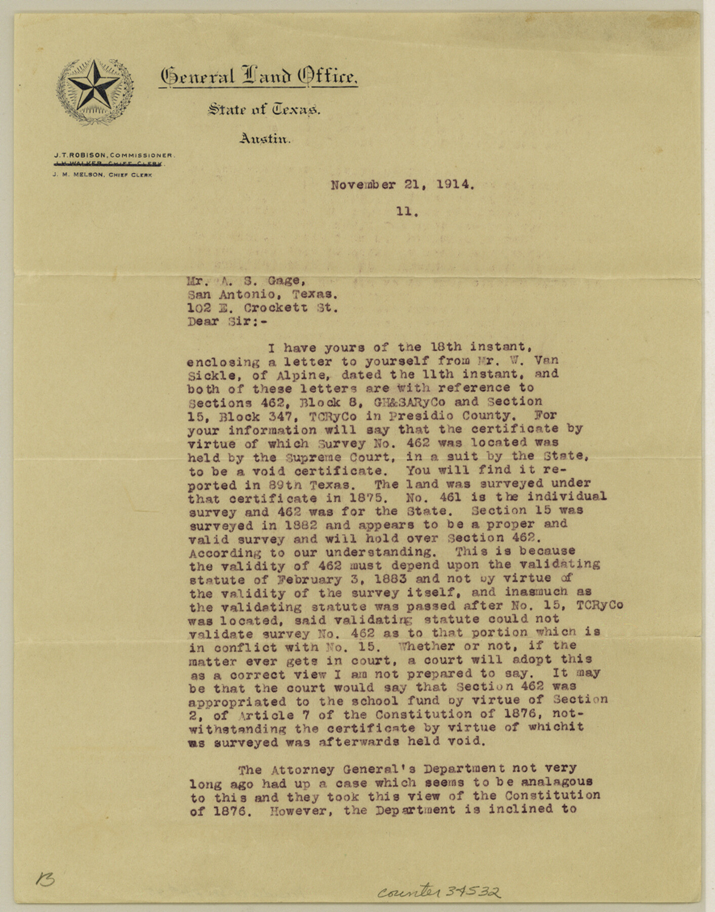
Presidio County Sketch File 45
[Letter regarding survey 462, Block 249, and survey 15, Block 347]
-
Map/Doc
34532
-
Collection
General Map Collection
-
Object Dates
11/21/1914 (Creation Date)
11/21/1914 (Correspondence Date)
-
Counties
Presidio
-
Subjects
Surveying Sketch File
-
Height x Width
11.3 x 8.8 inches
28.7 x 22.4 cm
-
Medium
paper, print
Part of: General Map Collection
Fort Bend County State Real Property Sketch 2

Print $40.00
- Digital $50.00
Fort Bend County State Real Property Sketch 2
1986
Size 34.8 x 43.4 inches
Map/Doc 61676
Flight Mission No. CRC-4R, Frame 73, Chambers County

Print $20.00
- Digital $50.00
Flight Mission No. CRC-4R, Frame 73, Chambers County
1956
Size 18.7 x 22.5 inches
Map/Doc 84877
Jeff Davis County Sketch File 35

Print $20.00
- Digital $50.00
Jeff Davis County Sketch File 35
1950
Size 20.6 x 19.2 inches
Map/Doc 11866
Montgomery County

Print $20.00
- Digital $50.00
Montgomery County
1901
Size 42.8 x 45.9 inches
Map/Doc 10794
Reeves County Rolled Sketch 10

Print $20.00
- Digital $50.00
Reeves County Rolled Sketch 10
Size 22.4 x 42.0 inches
Map/Doc 7480
Runnels County Sketch File 4

Print $6.00
Runnels County Sketch File 4
1871
Size 12.9 x 8.1 inches
Map/Doc 35434
Map of a part of Laguna Madre showing subdivision for mineral development

Print $40.00
- Digital $50.00
Map of a part of Laguna Madre showing subdivision for mineral development
1946
Size 50.0 x 29.0 inches
Map/Doc 2915

Mason County Working Sketch 13

Print $20.00
- Digital $50.00
Mason County Working Sketch 13
1954
Size 20.0 x 29.9 inches
Map/Doc 70849
Ochiltree County Boundary File 5a

Print $10.00
- Digital $50.00
Ochiltree County Boundary File 5a
Size 13.7 x 8.7 inches
Map/Doc 57692
Travis County Sketch File 65

Print $4.00
- Digital $50.00
Travis County Sketch File 65
1948
Size 9.1 x 9.1 inches
Map/Doc 38438
Orange County Rolled Sketch CR

Print $20.00
- Digital $50.00
Orange County Rolled Sketch CR
Size 39.4 x 31.5 inches
Map/Doc 9653
You may also like
Gillespie County Working Sketch 1

Print $20.00
- Digital $50.00
Gillespie County Working Sketch 1
1950
Size 23.9 x 18.7 inches
Map/Doc 63164
Martin County Working Sketch 2

Print $20.00
- Digital $50.00
Martin County Working Sketch 2
1944
Size 27.5 x 20.9 inches
Map/Doc 70820
Palo Pinto County Rolled Sketch 5

Print $40.00
- Digital $50.00
Palo Pinto County Rolled Sketch 5
Size 54.4 x 36.0 inches
Map/Doc 76021
Sterling County Rolled Sketch 13

Print $20.00
- Digital $50.00
Sterling County Rolled Sketch 13
1945
Size 34.9 x 27.3 inches
Map/Doc 7847

Stonewall County Working Sketch 27

Print $20.00
- Digital $50.00
Stonewall County Working Sketch 27
1976
Size 20.7 x 29.9 inches
Map/Doc 62334
Atascosa County Sketch File 31

Print $4.00
- Digital $50.00
Atascosa County Sketch File 31
1910
Size 9.4 x 4.3 inches
Map/Doc 13825
Working Sketch in Travis County

Print $20.00
- Digital $50.00
Working Sketch in Travis County
1923
Size 15.4 x 18.6 inches
Map/Doc 91866
[Surveys in the vicinity of Archer County School Land]
![90325, [Surveys in the vicinity of Archer County School Land], Twichell Survey Records](https://historictexasmaps.com/wmedia_w700/maps/90325-1.tif.jpg)
Print $20.00
- Digital $50.00
[Surveys in the vicinity of Archer County School Land]
Size 15.1 x 20.6 inches
Map/Doc 90325
Grayson County Sketch File 3a

Print $20.00
- Digital $50.00
Grayson County Sketch File 3a
1855
Size 19.6 x 25.5 inches
Map/Doc 11580

[Yates Field showing well locations]
![91670, [Yates Field showing well locations], Twichell Survey Records](https://historictexasmaps.com/wmedia_w700/maps/91670-1.tif.jpg)
Print $3.00
- Digital $50.00
[Yates Field showing well locations]
Size 14.4 x 11.3 inches
Map/Doc 91670