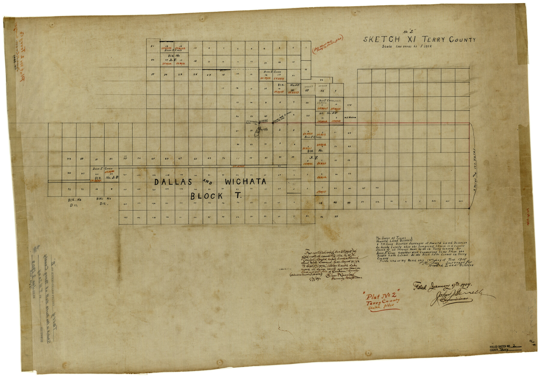
Terry County Rolled Sketch 2
[Sketch of Dallas and Wichita Block T and surrounding area in north part of county]
-
Map/Doc
7980
-
Collection
General Map Collection
-
Object Dates
11/19/1908 (Creation Date)
1/9/1909 (File Date)
-
People and Organizations
T.H. Seay (Surveyor/Engineer)
-
Counties
Terry
-
Subjects
Surveying Rolled Sketch
-
Height x Width
25.5 x 36.8 inches
64.8 x 93.5 cm
-
Medium
linen, manuscript
Part of: General Map Collection
Callahan County Sketch File 6

Print $42.00
- Digital $50.00
Callahan County Sketch File 6
1858
Size 8.2 x 6.4 inches
Map/Doc 35859
Uvalde County Rolled Sketch 18

Print $20.00
- Digital $50.00
Uvalde County Rolled Sketch 18
Size 33.2 x 24.8 inches
Map/Doc 8102
Anderson County Boundary File 3

Print $9.00
- Digital $50.00
Anderson County Boundary File 3
Size 14.3 x 8.8 inches
Map/Doc 49733
Titus County Boundary File 29

Print $72.00
- Digital $50.00
Titus County Boundary File 29
Size 9.0 x 4.1 inches
Map/Doc 59311
Culberson County Rolled Sketch 68

Print $20.00
- Digital $50.00
Culberson County Rolled Sketch 68
1997
Size 32.0 x 32.9 inches
Map/Doc 76402
Gray County Sketch File 12

Print $6.00
- Digital $50.00
Gray County Sketch File 12
1889
Size 17.0 x 8.3 inches
Map/Doc 24454
Dimmit County Rolled Sketch 5

Print $20.00
- Digital $50.00
Dimmit County Rolled Sketch 5
1904
Size 42.7 x 18.2 inches
Map/Doc 5715
[FT. W. & R. G. Ry. Right of Way Map, Winchell to Brady, McCulloch County, Texas]
![61415, [FT. W. & R. G. Ry. Right of Way Map, Winchell to Brady, McCulloch County, Texas], General Map Collection](https://historictexasmaps.com/wmedia_w700/maps/61415.tif.jpg)
Print $40.00
- Digital $50.00
[FT. W. & R. G. Ry. Right of Way Map, Winchell to Brady, McCulloch County, Texas]
1918
Size 38.2 x 122.0 inches
Map/Doc 61415
Flight Mission No. CRC-6R, Frame 38, Chambers County

Print $20.00
- Digital $50.00
Flight Mission No. CRC-6R, Frame 38, Chambers County
1956
Size 18.7 x 22.4 inches
Map/Doc 84971
Henderson County

Print $40.00
- Digital $50.00
Henderson County
1922
Size 39.3 x 49.1 inches
Map/Doc 4683

Kerr County Working Sketch 2

Print $20.00
- Digital $50.00
Kerr County Working Sketch 2
1926
Size 18.6 x 17.9 inches
Map/Doc 70033
You may also like
Cochran County Sketch File 5

Print $24.00
- Digital $50.00
Cochran County Sketch File 5
1932
Size 11.1 x 8.7 inches
Map/Doc 18542
Flight Mission No. BRA-9M, Frame 75, Jefferson County

Print $20.00
- Digital $50.00
Flight Mission No. BRA-9M, Frame 75, Jefferson County
1953
Size 18.6 x 22.5 inches
Map/Doc 85658
Yoakum County Sketch File 13

Print $49.00
- Digital $50.00
Yoakum County Sketch File 13
1898
Size 8.3 x 8.6 inches
Map/Doc 40767
Jackson County Working Sketch 8

Print $20.00
- Digital $50.00
Jackson County Working Sketch 8
1980
Size 30.4 x 29.0 inches
Map/Doc 66456
[Surveys in Austin's Colony by Horatio Chriesman along Mill and Cummins Creeks]
![68, [Surveys in Austin's Colony by Horatio Chriesman along Mill and Cummins Creeks], General Map Collection](https://historictexasmaps.com/wmedia_w700/maps/68.tif.jpg)
Print $20.00
- Digital $50.00
[Surveys in Austin's Colony by Horatio Chriesman along Mill and Cummins Creeks]
1830
Size 30.7 x 25.7 inches
Map/Doc 68
Maverick County Sketch File 10

Print $22.00
- Digital $50.00
Maverick County Sketch File 10
Size 8.6 x 7.0 inches
Map/Doc 31072
Travis County Sketch File 75B

Print $20.00
- Digital $50.00
Travis County Sketch File 75B
1992
Size 37.4 x 26.7 inches
Map/Doc 12479
The Republic County of Milam. February 4, 1840

Print $20.00
The Republic County of Milam. February 4, 1840
2020
Size 17.4 x 21.6 inches
Map/Doc 96229
Station Map, the Missouri, Kansas and Texas Ry. Of Texas - Henrietta Division

Print $20.00
- Digital $50.00
Station Map, the Missouri, Kansas and Texas Ry. Of Texas - Henrietta Division
1918
Size 11.8 x 26.7 inches
Map/Doc 64763
Mills County Working Sketch 11

Print $20.00
- Digital $50.00
Mills County Working Sketch 11
1930
Size 22.5 x 14.4 inches
Map/Doc 71041
Palo Pinto County

Print $40.00
- Digital $50.00
Palo Pinto County
1941
Size 48.3 x 39.3 inches
Map/Doc 73256
Pecos County Rolled Sketch 117

Print $40.00
- Digital $50.00
Pecos County Rolled Sketch 117
1944
Size 44.6 x 52.6 inches
Map/Doc 9722