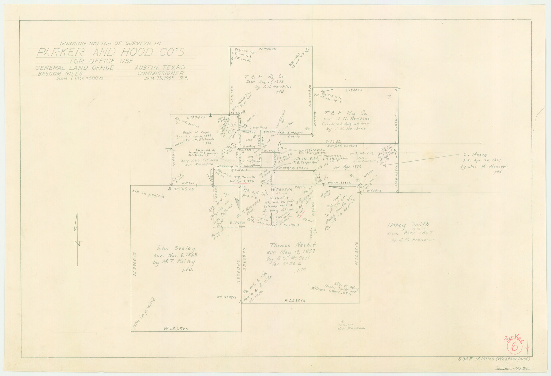
Parker County Working Sketch 6
-
Map/Doc
71456
-
Collection
General Map Collection
-
Object Dates
6/25/1953 (Creation Date)
-
People and Organizations
Roy Buckholts (Draftsman)
-
Counties
Parker Hood
-
Subjects
Surveying Working Sketch
-
Scale
1" = 500 varas
Part of: General Map Collection
Map of Dawson County

Print $20.00
- Digital $50.00
Map of Dawson County
1900
Size 40.0 x 36.5 inches
Map/Doc 4929
Jasper County Sketch File 26

Print $16.00
- Digital $50.00
Jasper County Sketch File 26
1944
Size 11.2 x 8.8 inches
Map/Doc 27834
Flight Mission No. CUG-2P, Frame 8, Kleberg County

Print $20.00
- Digital $50.00
Flight Mission No. CUG-2P, Frame 8, Kleberg County
1956
Size 18.5 x 22.2 inches
Map/Doc 86180
Waller County Sketch File 5

Print $6.00
- Digital $50.00
Waller County Sketch File 5
Size 10.7 x 14.1 inches
Map/Doc 39600
Flight Mission No. DAH-17M, Frame 22, Orange County

Print $20.00
- Digital $50.00
Flight Mission No. DAH-17M, Frame 22, Orange County
1953
Size 18.8 x 22.6 inches
Map/Doc 86885
Lavaca County Sketch File 2

Print $6.00
- Digital $50.00
Lavaca County Sketch File 2
1849
Size 8.7 x 7.5 inches
Map/Doc 29630
Hudspeth County Rolled Sketch 66

Print $20.00
- Digital $50.00
Hudspeth County Rolled Sketch 66
1973
Size 12.1 x 19.9 inches
Map/Doc 6260
Harris County Rolled Sketch 86

Print $20.00
- Digital $50.00
Harris County Rolled Sketch 86
1933
Size 33.5 x 32.4 inches
Map/Doc 73575
Van Zandt County Sketch File 39

Print $6.00
- Digital $50.00
Van Zandt County Sketch File 39
1871
Size 10.8 x 13.4 inches
Map/Doc 39484
Controlled Mosaic by Jack Amman Photogrammetric Engineers, Inc - Sheet 23

Print $20.00
- Digital $50.00
Controlled Mosaic by Jack Amman Photogrammetric Engineers, Inc - Sheet 23
1954
Size 20.0 x 24.0 inches
Map/Doc 83474
Brazos Santiago, Texas

Print $20.00
- Digital $50.00
Brazos Santiago, Texas
1900
Size 18.3 x 26.9 inches
Map/Doc 73031
Panola County Working Sketch 11

Print $20.00
- Digital $50.00
Panola County Working Sketch 11
1944
Map/Doc 71420
You may also like
Hays County Working Sketch 11

Print $20.00
- Digital $50.00
Hays County Working Sketch 11
1950
Size 22.7 x 33.1 inches
Map/Doc 66085
Terrell County Working Sketch 63

Print $20.00
- Digital $50.00
Terrell County Working Sketch 63
1970
Size 37.8 x 35.9 inches
Map/Doc 69584
Working Sketch in Wheeler County [showing East line of County along border with Oklahoma]
![92085, Working Sketch in Wheeler County [showing East line of County along border with Oklahoma], Twichell Survey Records](https://historictexasmaps.com/wmedia_w700/maps/92085-1.tif.jpg)
Print $20.00
- Digital $50.00
Working Sketch in Wheeler County [showing East line of County along border with Oklahoma]
1910
Size 4.8 x 26.1 inches
Map/Doc 92085
Crane County Rolled Sketch 22

Print $20.00
- Digital $50.00
Crane County Rolled Sketch 22
1990
Size 12.5 x 19.3 inches
Map/Doc 5578
Terrell County Working Sketch 25

Print $40.00
- Digital $50.00
Terrell County Working Sketch 25
1942
Size 41.9 x 49.1 inches
Map/Doc 62175
Carta Particular de las Costas Setentrionales del Seno Mexicano que comprehende las de la Florida Ocidental las Margenes de la Luisiana y toda la rivera que sigue por la Bahía de San Bernardo y el Río Bravo del Norte hasta la Laguna Madre

Carta Particular de las Costas Setentrionales del Seno Mexicano que comprehende las de la Florida Ocidental las Margenes de la Luisiana y toda la rivera que sigue por la Bahía de San Bernardo y el Río Bravo del Norte hasta la Laguna Madre
1825
Size 26.1 x 38.7 inches
Map/Doc 94568
Shackelford County Sketch File 5

Print $4.00
- Digital $50.00
Shackelford County Sketch File 5
1885
Size 12.3 x 7.6 inches
Map/Doc 36578
Brewster County Rolled Sketch 114

Print $20.00
- Digital $50.00
Brewster County Rolled Sketch 114
1964
Size 11.4 x 18.4 inches
Map/Doc 5277
Coast Chart No. 209 - Aransas Pass, Aransas and Copano Bays, Texas

Print $20.00
- Digital $50.00
Coast Chart No. 209 - Aransas Pass, Aransas and Copano Bays, Texas
1906
Size 40.2 x 33.8 inches
Map/Doc 73430
Sutton County Sketch File E2

Print $20.00
- Digital $50.00
Sutton County Sketch File E2
Size 16.8 x 19.0 inches
Map/Doc 12397

Cottle County Sketch File 7 1/2

Print $26.00
- Digital $50.00
Cottle County Sketch File 7 1/2
1889
Size 40.2 x 21.0 inches
Map/Doc 10342