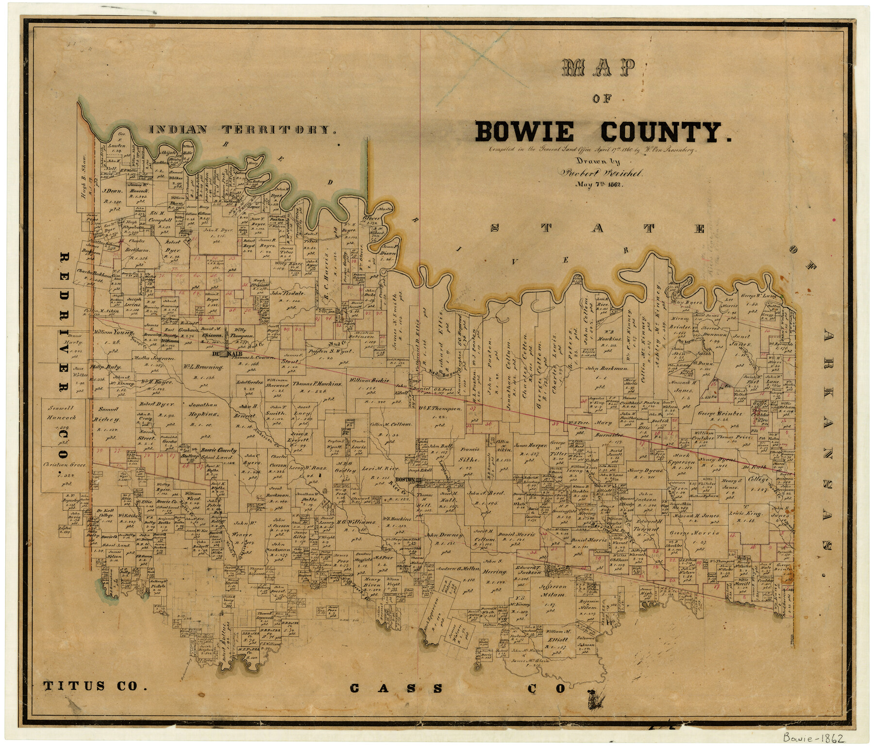
Map of Bowie County
-
Map/Doc
3317
-
Collection
General Map Collection
-
Object Dates
4/17/1860 (Compilation Date)
5/7/1862 (Creation Date)
-
People and Organizations
Texas General Land Office (Publisher)
Robert Reichel (Draftsman)
W. von Rosenberg (Compiler)
-
Counties
Bowie
-
Subjects
County
-
Height x Width
20.0 x 23.5 inches
50.8 x 59.7 cm
-
Comments
Compiled April 17, 1860; drawn May 7, 1862.
-
Features
Boston
Stephenson's Ferry
Brook's Creek
Janes Creek
Herring's Creek
Elliott's Creek
Weavers Creek
Boothe's Creek
Blythe Creek
Rice Creek
Harber's Creek
McKinney Creek
Spanish Bluff Indian Territory
Langham's Creek
Anderson Creek
Ward's Creek
Red Bayou
McKinney's Creek
Burkman's Creek
Mill Bayou
Mud Creek
DeKalb
Young's Creek
Part of: General Map Collection

The Railroad System of Texas on September 1st, 1887

Print $20.00
- Digital $50.00
The Railroad System of Texas on September 1st, 1887
1887
Size 22.2 x 28.2 inches
Map/Doc 3036
Cooke County Working Sketch 7

Print $20.00
- Digital $50.00
Cooke County Working Sketch 7
1939
Size 25.1 x 33.7 inches
Map/Doc 68244
Flight Mission No. DAG-24K, Frame 137, Matagorda County

Print $20.00
- Digital $50.00
Flight Mission No. DAG-24K, Frame 137, Matagorda County
1953
Size 18.5 x 22.2 inches
Map/Doc 86555
Midland County Rolled Sketch 4B

Print $40.00
- Digital $50.00
Midland County Rolled Sketch 4B
1951
Size 77.5 x 25.1 inches
Map/Doc 10725
Orange County Working Sketch 1

Print $20.00
- Digital $50.00
Orange County Working Sketch 1
1914
Size 16.1 x 18.2 inches
Map/Doc 71333
Connected Map of the County of Victoria

Print $40.00
- Digital $50.00
Connected Map of the County of Victoria
1838
Size 79.7 x 49.0 inches
Map/Doc 1946
Zavalla [sic] County
![16939, Zavalla [sic] County, General Map Collection](https://historictexasmaps.com/wmedia_w700/maps/16939.tif.jpg)
Print $20.00
- Digital $50.00
Zavalla [sic] County
1893
Size 44.5 x 46.3 inches
Map/Doc 16939
Leon County Sketch File 9a

Print $6.00
- Digital $50.00
Leon County Sketch File 9a
1863
Size 10.5 x 8.6 inches
Map/Doc 29728
Fisher County Working Sketch 6

Print $20.00
- Digital $50.00
Fisher County Working Sketch 6
1929
Size 38.7 x 33.6 inches
Map/Doc 69140
Nueces County Sketch File 16

Print $6.00
- Digital $50.00
Nueces County Sketch File 16
1875
Size 15.5 x 10.7 inches
Map/Doc 32547
Anderson County Sketch File 23

Print $10.00
- Digital $50.00
Anderson County Sketch File 23
1942
Size 11.2 x 8.7 inches
Map/Doc 12794
You may also like
Upton County Working Sketch Graphic Index, Sheet 2 (Sketches 40 to Most Recent)

Print $40.00
- Digital $50.00
Upton County Working Sketch Graphic Index, Sheet 2 (Sketches 40 to Most Recent)
1969
Size 49.7 x 36.8 inches
Map/Doc 76722
Flight Mission No. DCL-6C, Frame 53, Kenedy County

Print $20.00
- Digital $50.00
Flight Mission No. DCL-6C, Frame 53, Kenedy County
1943
Size 18.6 x 22.4 inches
Map/Doc 85895
Red River County Sketch File 1a

Print $4.00
- Digital $50.00
Red River County Sketch File 1a
1854
Size 12.7 x 8.0 inches
Map/Doc 35093
[Blocks 242, 243, and 244]
![90999, [Blocks 242, 243, and 244], Twichell Survey Records](https://historictexasmaps.com/wmedia_w700/maps/90999-1.tif.jpg)
Print $2.00
- Digital $50.00
[Blocks 242, 243, and 244]
Size 9.2 x 14.8 inches
Map/Doc 90999
Gillespie County Rolled Sketch 2

Print $20.00
- Digital $50.00
Gillespie County Rolled Sketch 2
1977
Size 22.8 x 22.7 inches
Map/Doc 6009
Foard County Sketch File 35

Print $20.00
- Digital $50.00
Foard County Sketch File 35
Size 25.2 x 24.8 inches
Map/Doc 6067
[Block 35, Townships 3N, 4N, and 5N]
![90640, [Block 35, Townships 3N, 4N, and 5N], Twichell Survey Records](https://historictexasmaps.com/wmedia_w700/maps/90640-1.tif.jpg)
Print $40.00
- Digital $50.00
[Block 35, Townships 3N, 4N, and 5N]
Size 15.6 x 48.1 inches
Map/Doc 90640
Map of Caldwell County, Land District since August 1st. 1859; Originally the part north, east of the line designated Bastrop - the balance, Gonzales Land District

Print $20.00
- Digital $50.00
Map of Caldwell County, Land District since August 1st. 1859; Originally the part north, east of the line designated Bastrop - the balance, Gonzales Land District
1861
Size 19.9 x 23.0 inches
Map/Doc 3355
Gonzales County Working Sketch 9

Print $20.00
- Digital $50.00
Gonzales County Working Sketch 9
1981
Size 18.8 x 18.2 inches
Map/Doc 63225
Harris County Rolled Sketch 96C

Print $3.00
- Digital $50.00
Harris County Rolled Sketch 96C
Size 10.5 x 10.5 inches
Map/Doc 10653
McMullen and McGloin Empresario Colony. August 16, 1828

Print $20.00
McMullen and McGloin Empresario Colony. August 16, 1828
2020
Size 17.6 x 21.7 inches
Map/Doc 95998
