Nueces County Rolled Sketch 111
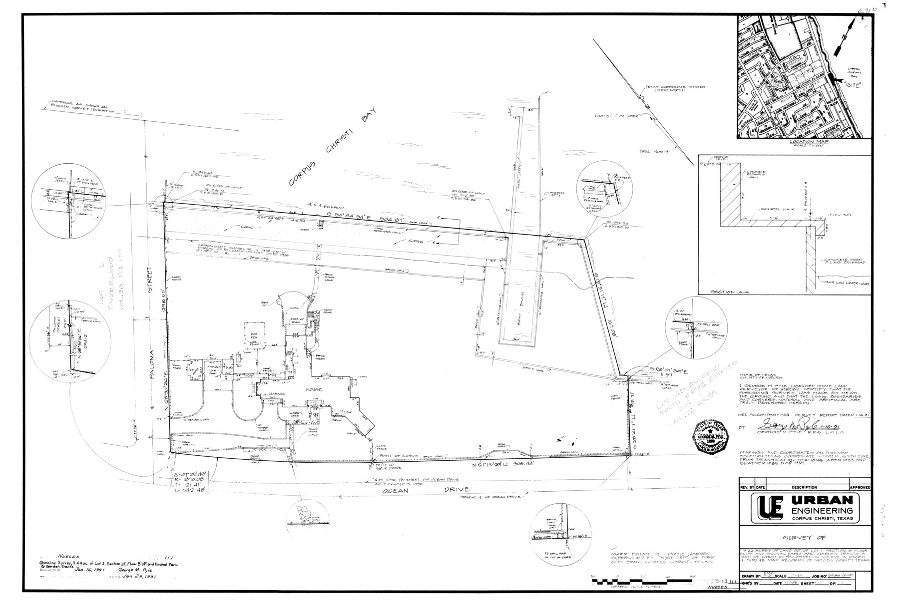
Survey of 3.44 acres of land out of Lot 1, section 15, Flour Bluff and Encinal Farm and Garden Tracts
-
Map/Doc
7119
-
Collection
General Map Collection
-
Object Dates
1991/1/16 (Creation Date)
1991/1/24 (File Date)
-
People and Organizations
George M. Pyle (Surveyor/Engineer)
-
Counties
Nueces
-
Subjects
Surveying Rolled Sketch
-
Height x Width
24.6 x 36.1 inches
62.5 x 91.7 cm
-
Medium
mylar, print
-
Scale
1" = 30 feet
-
Comments
See Nueces County Sketch File 71 (33011).
Related maps
Nueces County Sketch File 71

Print $19.00
- Digital $50.00
Nueces County Sketch File 71
1991
Size 11.2 x 8.7 inches
Map/Doc 33011
Part of: General Map Collection
Kimble County Sketch File 40

Print $14.00
- Digital $50.00
Kimble County Sketch File 40
1888
Size 10.8 x 8.6 inches
Map/Doc 29003
Flight Mission No. DIX-3P, Frame 136, Aransas County

Print $20.00
- Digital $50.00
Flight Mission No. DIX-3P, Frame 136, Aransas County
1956
Size 17.9 x 19.0 inches
Map/Doc 83766
West Part El Paso Co.

Print $20.00
- Digital $50.00
West Part El Paso Co.
1908
Size 46.8 x 42.4 inches
Map/Doc 4713
Flight Mission No. CUG-2P, Frame 27, Kleberg County

Print $20.00
- Digital $50.00
Flight Mission No. CUG-2P, Frame 27, Kleberg County
1956
Size 18.9 x 22.5 inches
Map/Doc 86192
Flight Mission No. DQO-3K, Frame 36, Galveston County

Print $20.00
- Digital $50.00
Flight Mission No. DQO-3K, Frame 36, Galveston County
1952
Size 18.7 x 22.4 inches
Map/Doc 85077
Terrell County Working Sketch 55

Print $20.00
- Digital $50.00
Terrell County Working Sketch 55
1959
Size 25.9 x 43.4 inches
Map/Doc 62148
Oso Creek, Cabaniss Field (P-2) Sheet

Print $6.00
- Digital $50.00
Oso Creek, Cabaniss Field (P-2) Sheet
1942
Size 36.1 x 25.8 inches
Map/Doc 65097
Presidio County Working Sketch 114

Print $40.00
- Digital $50.00
Presidio County Working Sketch 114
1981
Size 63.9 x 37.9 inches
Map/Doc 71791
Anderson County Working Sketch 46

Print $20.00
- Digital $50.00
Anderson County Working Sketch 46
2000
Size 29.2 x 34.2 inches
Map/Doc 67046
[Beaumont, Sour Lake and Western Ry. Right of Way and Alignment - Frisco]
![64132, [Beaumont, Sour Lake and Western Ry. Right of Way and Alignment - Frisco], General Map Collection](https://historictexasmaps.com/wmedia_w700/maps/64132.tif.jpg)
Print $20.00
- Digital $50.00
[Beaumont, Sour Lake and Western Ry. Right of Way and Alignment - Frisco]
1910
Size 19.9 x 46.1 inches
Map/Doc 64132
Knox County Sketch File 7

Print $40.00
- Digital $50.00
Knox County Sketch File 7
1885
Size 32.2 x 19.9 inches
Map/Doc 11955
Flight Mission No. CRK-5P, Frame 156, Refugio County

Print $20.00
- Digital $50.00
Flight Mission No. CRK-5P, Frame 156, Refugio County
1956
Size 18.5 x 22.5 inches
Map/Doc 86937
You may also like
Henderson County Rolled Sketch 11

Print $20.00
- Digital $50.00
Henderson County Rolled Sketch 11
1915
Size 29.4 x 42.5 inches
Map/Doc 75956
Sutton County Sketch File 11

Print $10.00
- Digital $50.00
Sutton County Sketch File 11
1898
Size 14.2 x 8.8 inches
Map/Doc 37374
The Chief Justice County of Jasper. Lands in Conflict with Sabine County

Print $20.00
The Chief Justice County of Jasper. Lands in Conflict with Sabine County
2020
Size 18.3 x 21.7 inches
Map/Doc 96053
San Jacinto County Working Sketch 31

Print $20.00
- Digital $50.00
San Jacinto County Working Sketch 31
1953
Size 29.1 x 30.4 inches
Map/Doc 63744
[East line of Wheeler County along Oklahoma]
![89825, [East line of Wheeler County along Oklahoma], Twichell Survey Records](https://historictexasmaps.com/wmedia_w700/maps/89825-1.tif.jpg)
Print $40.00
- Digital $50.00
[East line of Wheeler County along Oklahoma]
Size 8.5 x 62.9 inches
Map/Doc 89825
Map of the city of San Antonio, Bexar County, Texas including suburbs both north and south

Print $20.00
Map of the city of San Antonio, Bexar County, Texas including suburbs both north and south
1924
Size 37.0 x 24.5 inches
Map/Doc 93556
Harris County Working Sketch 122

Print $20.00
- Digital $50.00
Harris County Working Sketch 122
1986
Size 30.0 x 40.1 inches
Map/Doc 66014
Flight Mission No. BRA-16M, Frame 104, Jefferson County

Print $20.00
- Digital $50.00
Flight Mission No. BRA-16M, Frame 104, Jefferson County
1953
Size 18.5 x 22.3 inches
Map/Doc 85716
A Few Things About Rice as grown along the line of the Sunset Route in Louisiana and Texas

A Few Things About Rice as grown along the line of the Sunset Route in Louisiana and Texas
1904
Map/Doc 96724
[Topographical Map showing part of Miller Day Ranch in Southwest Part of Coleman County]
![81515, [Topographical Map showing part of Miller Day Ranch in Southwest Part of Coleman County], General Map Collection](https://historictexasmaps.com/wmedia_w700/maps/81515.tif.jpg)
Print $3.00
- Digital $50.00
[Topographical Map showing part of Miller Day Ranch in Southwest Part of Coleman County]
Size 11.3 x 17.3 inches
Map/Doc 81515
Terrell County Rolled Sketch 1

Print $20.00
- Digital $50.00
Terrell County Rolled Sketch 1
1906
Size 31.2 x 22.5 inches
Map/Doc 7924
Eastland County Working Sketch 57

Print $20.00
- Digital $50.00
Eastland County Working Sketch 57
1985
Size 21.7 x 21.8 inches
Map/Doc 68838