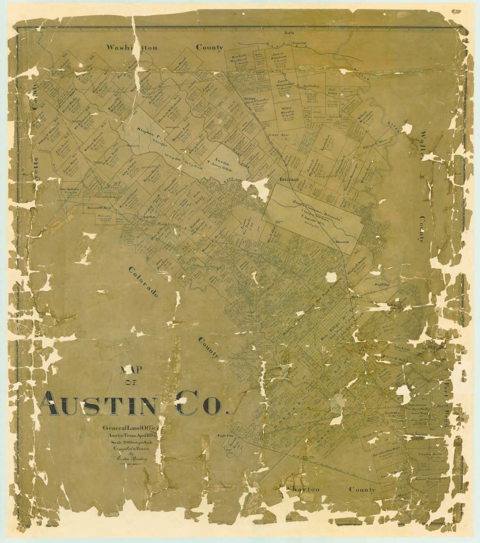
Map of Austin Co.
-
Map/Doc
4795
-
Collection
General Map Collection
-
Object Dates
1895 (Creation Date)
-
People and Organizations
Texas General Land Office (Publisher)
E. von Rosenberg (Draftsman)
E. von Rosenberg (Compiler)
-
Counties
Austin
-
Subjects
County
-
Height x Width
49.3 x 43.6 inches
125.2 x 110.7 cm
-
Comments
Big grants in color.
Partially adopted by Charles and Caroline von Rosenberg, Dale and Marjorie von Rosenberg, ExxonMobil Foundation, Mobil Retiree Matching Gifts Program, and Helen W. Dinwiddle. -
Features
GH&SA
East Fork of Brazos River
Rockhouse Post Office
Industry Post Office
Nelsonville Post Office
Blieblerville Post Office
Shelby Post Office
Cochran Post Office
Kenney
Willow Branch of Coshattee Creek
West Fork of Brazos River
Eagle Lake
SA&AP
San Bernard River
Coshattee Creek
Lone Tree Branch of San Bernard River
Coshattee Branch
East Fork of San Bernard River
GC&SF
Lone Cycamore [sic] Creek
Southern Pacific Railroad Company
Lissie Post Office
New Philadelphia
Eagle Lake
Chester Station
Canfield's Point
12 Mile Creek
Richard's Creek
Beard
Old Lakey Road
Hog Branch of San Bernard River
Little Bernard Creek
Cat Spring's Station
Millheim Post Office
New Ulm
Old New Ulm
Sandy Creek
Old Newton
Jackson's Creek
Bell's Lake
Old San Felipe Road
Piney Creek
Bellville
Pastoren Creek
Cottonwood Branch
Cummins Creek
Old Coshattee Road
Camp Creek
Walnut Creek
Brushy Creek
Plum Creek
Dogwood Creek
Welcome Post Office
Brazos River
Chappell Hill
Caney Creek
H&TC
Pine Fork of San Bernard River
German Creek
Columbus Road
Sealy
TWRR
MK&T
San Felipe
Arroyo Dulce
Willow Creek
Redgate Creek
Yopon [sic] Creek
Yellow Creek
Panther Creek
Millheim
Boggy Creek
Pecan Branch of Cummins Creek
Andrews Creek
Percimmon Branch of Cummins Creek
Wright's Creek
Part of: General Map Collection
Flight Mission No. DAG-24K, Frame 129, Matagorda County

Print $20.00
- Digital $50.00
Flight Mission No. DAG-24K, Frame 129, Matagorda County
1953
Size 18.5 x 22.2 inches
Map/Doc 86547
San Patricio County Sketch File 42

Print $89.00
- Digital $50.00
San Patricio County Sketch File 42
1979
Size 11.3 x 8.8 inches
Map/Doc 36240
St. Louis Southwestern Railway of Texas

Print $20.00
- Digital $50.00
St. Louis Southwestern Railway of Texas
1906
Size 22.6 x 30.3 inches
Map/Doc 64448
Concho County Sketch File 22

Print $20.00
- Digital $50.00
Concho County Sketch File 22
Size 24.9 x 18.1 inches
Map/Doc 11155
Coleman County Sketch File 4a

Print $20.00
- Digital $50.00
Coleman County Sketch File 4a
1873
Size 12.4 x 20.9 inches
Map/Doc 11118
Montague County Sketch File 14

Print $4.00
- Digital $50.00
Montague County Sketch File 14
1880
Size 7.8 x 5.4 inches
Map/Doc 31740
Stonewall County Sketch File 19

Print $20.00
- Digital $50.00
Stonewall County Sketch File 19
Size 33.2 x 33.6 inches
Map/Doc 10392
Brewster County Working Sketch 118

Print $20.00
- Digital $50.00
Brewster County Working Sketch 118
1929
Size 27.0 x 20.5 inches
Map/Doc 67718
Kinney County Rolled Sketch 6

Print $20.00
- Digital $50.00
Kinney County Rolled Sketch 6
Size 27.1 x 36.8 inches
Map/Doc 6536
Gillespie County Sketch File 10

Print $4.00
- Digital $50.00
Gillespie County Sketch File 10
1877
Size 8.3 x 12.9 inches
Map/Doc 24147
Wilbarger Co.

Print $40.00
- Digital $50.00
Wilbarger Co.
1907
Size 49.0 x 39.3 inches
Map/Doc 16927
Flight Mission No. DQN-5K, Frame 144, Calhoun County

Print $20.00
- Digital $50.00
Flight Mission No. DQN-5K, Frame 144, Calhoun County
1953
Size 18.6 x 22.3 inches
Map/Doc 84419
You may also like
United States - Gulf Coast Texas - Southern part of Laguna Madre

Print $20.00
- Digital $50.00
United States - Gulf Coast Texas - Southern part of Laguna Madre
1933
Size 26.6 x 18.3 inches
Map/Doc 72951
Burleson County Working Sketch 12

Print $20.00
- Digital $50.00
Burleson County Working Sketch 12
1980
Size 20.6 x 12.0 inches
Map/Doc 67731
Montgomery County Sketch File 2a

Print $4.00
- Digital $50.00
Montgomery County Sketch File 2a
1849
Size 8.0 x 12.3 inches
Map/Doc 31768
The Republic County of Colorado. January 1, 1838

Print $20.00
The Republic County of Colorado. January 1, 1838
2020
Size 18.4 x 21.7 inches
Map/Doc 96120
Wharton County Sketch File 6

Print $4.00
- Digital $50.00
Wharton County Sketch File 6
1877
Size 8.6 x 14.2 inches
Map/Doc 39923
Starr County Rolled Sketch 35

Print $20.00
- Digital $50.00
Starr County Rolled Sketch 35
1925
Size 40.1 x 12.8 inches
Map/Doc 7832
Crockett County Sketch File 22

Print $12.00
- Digital $50.00
Crockett County Sketch File 22
1881
Size 13.1 x 8.1 inches
Map/Doc 19691
Flight Mission No. CRK-7P, Frame 79, Refugio County

Print $20.00
- Digital $50.00
Flight Mission No. CRK-7P, Frame 79, Refugio County
1956
Size 18.2 x 22.1 inches
Map/Doc 86950
No. IX - Outline map of the vicinity of Corpus Christi

Print $20.00
- Digital $50.00
No. IX - Outline map of the vicinity of Corpus Christi
Size 24.9 x 18.2 inches
Map/Doc 72966
Matagorda County Rolled Sketch 22

Print $20.00
- Digital $50.00
Matagorda County Rolled Sketch 22
Size 30.7 x 23.9 inches
Map/Doc 6689
Orange County Sketch File 9a

Print $4.00
- Digital $50.00
Orange County Sketch File 9a
1873
Size 8.1 x 7.5 inches
Map/Doc 33313
Real County Sketch File 3

Print $16.00
- Digital $50.00
Real County Sketch File 3
1906
Size 9.2 x 8.2 inches
Map/Doc 35039