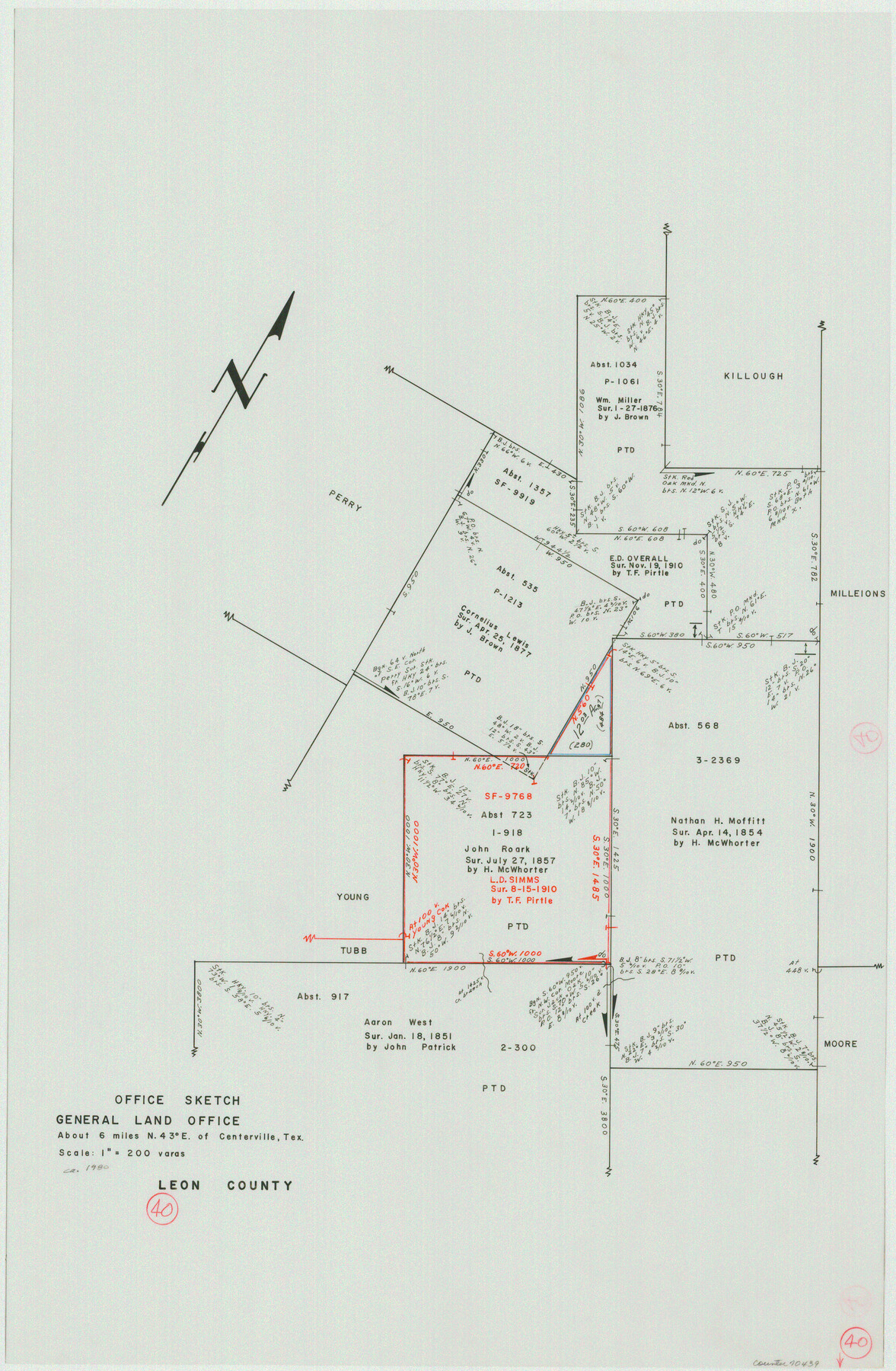
Leon County Working Sketch 40
-
Map/Doc
70439
-
Collection
General Map Collection
-
Object Dates
1980 ca. (Creation Date)
-
Counties
Leon
-
Subjects
Surveying Working Sketch
-
Height x Width
31.4 x 20.5 inches
79.8 x 52.1 cm
-
Scale
1" = 200 varas
Part of: General Map Collection
Montague County Sketch File 12

Print $4.00
- Digital $50.00
Montague County Sketch File 12
Size 11.4 x 8.2 inches
Map/Doc 31736
East Part of West Bay and Southwest Part of Galveston Bay, Galveston County, showing Subdivision for Mineral Development

Print $40.00
- Digital $50.00
East Part of West Bay and Southwest Part of Galveston Bay, Galveston County, showing Subdivision for Mineral Development
1963
Size 42.2 x 58.2 inches
Map/Doc 1906
Flight Mission No. BQY-4M, Frame 59, Harris County

Print $20.00
- Digital $50.00
Flight Mission No. BQY-4M, Frame 59, Harris County
1953
Size 18.5 x 22.3 inches
Map/Doc 85268
Sulphur River, Ringo Crossing Sheet

Print $20.00
- Digital $50.00
Sulphur River, Ringo Crossing Sheet
1933
Size 30.5 x 35.9 inches
Map/Doc 65162
Jeff Davis County Sketch File 27

Print $20.00
- Digital $50.00
Jeff Davis County Sketch File 27
1915
Size 18.8 x 25.5 inches
Map/Doc 11862
Duval County Rolled Sketch 33A

Print $40.00
- Digital $50.00
Duval County Rolled Sketch 33A
1949
Size 43.8 x 79.5 inches
Map/Doc 8818
Clay County Working Sketch 2

Print $20.00
- Digital $50.00
Clay County Working Sketch 2
1907
Size 26.5 x 16.2 inches
Map/Doc 68025
Flight Mission No. CGI-4N, Frame 185, Cameron County

Print $20.00
- Digital $50.00
Flight Mission No. CGI-4N, Frame 185, Cameron County
1955
Size 18.6 x 22.3 inches
Map/Doc 84688

Coryell County Working Sketch 6

Print $20.00
- Digital $50.00
Coryell County Working Sketch 6
1941
Size 15.9 x 13.6 inches
Map/Doc 68213
Refugio County Working Sketch 17

Print $20.00
- Digital $50.00
Refugio County Working Sketch 17
1980
Size 17.7 x 30.1 inches
Map/Doc 63526
Tarrant County

Print $20.00
- Digital $50.00
Tarrant County
1857
Size 20.9 x 15.4 inches
Map/Doc 4628
You may also like
Nolan County Sketch File 9

Print $26.00
- Digital $50.00
Nolan County Sketch File 9
1902
Size 14.3 x 9.0 inches
Map/Doc 32465
Dimmit County Working Sketch 16

Print $20.00
- Digital $50.00
Dimmit County Working Sketch 16
1943
Size 25.6 x 24.8 inches
Map/Doc 68677
General Highway Map. Detail of Cities and Towns in Dallas County, Texas [Dallas and vicinity]
![79435, General Highway Map. Detail of Cities and Towns in Dallas County, Texas [Dallas and vicinity], Texas State Library and Archives](https://historictexasmaps.com/wmedia_w700/maps/79435.tif.jpg)
Print $20.00
General Highway Map. Detail of Cities and Towns in Dallas County, Texas [Dallas and vicinity]
1961
Size 18.2 x 24.6 inches
Map/Doc 79435
Flight Mission No. BQR-22K, Frame 37, Brazoria County

Print $20.00
- Digital $50.00
Flight Mission No. BQR-22K, Frame 37, Brazoria County
1953
Size 18.8 x 22.4 inches
Map/Doc 84121
Brewster County Working Sketch 59

Print $20.00
- Digital $50.00
Brewster County Working Sketch 59
1955
Size 24.6 x 19.0 inches
Map/Doc 67660
Map of Wichita County

Print $20.00
- Digital $50.00
Map of Wichita County
1874
Size 22.8 x 21.0 inches
Map/Doc 4142
Plat Showing Subdivision of Wilbarger County School Land Hockley County, Texas

Print $20.00
- Digital $50.00
Plat Showing Subdivision of Wilbarger County School Land Hockley County, Texas
1947
Size 20.0 x 20.9 inches
Map/Doc 92255
Smith County Working Sketch 6

Print $20.00
- Digital $50.00
Smith County Working Sketch 6
1940
Size 15.7 x 25.7 inches
Map/Doc 63891
Matagorda County NRC Article 33.136 Sketch 9

Print $28.00
- Digital $50.00
Matagorda County NRC Article 33.136 Sketch 9
2011
Size 24.0 x 36.0 inches
Map/Doc 94811
Map of County Roads in Moore County

Print $20.00
- Digital $50.00
Map of County Roads in Moore County
Size 22.2 x 21.2 inches
Map/Doc 93005

Leon County Sketch File 10

Print $64.00
- Digital $50.00
Leon County Sketch File 10
1871
Size 10.6 x 15.7 inches
Map/Doc 29731