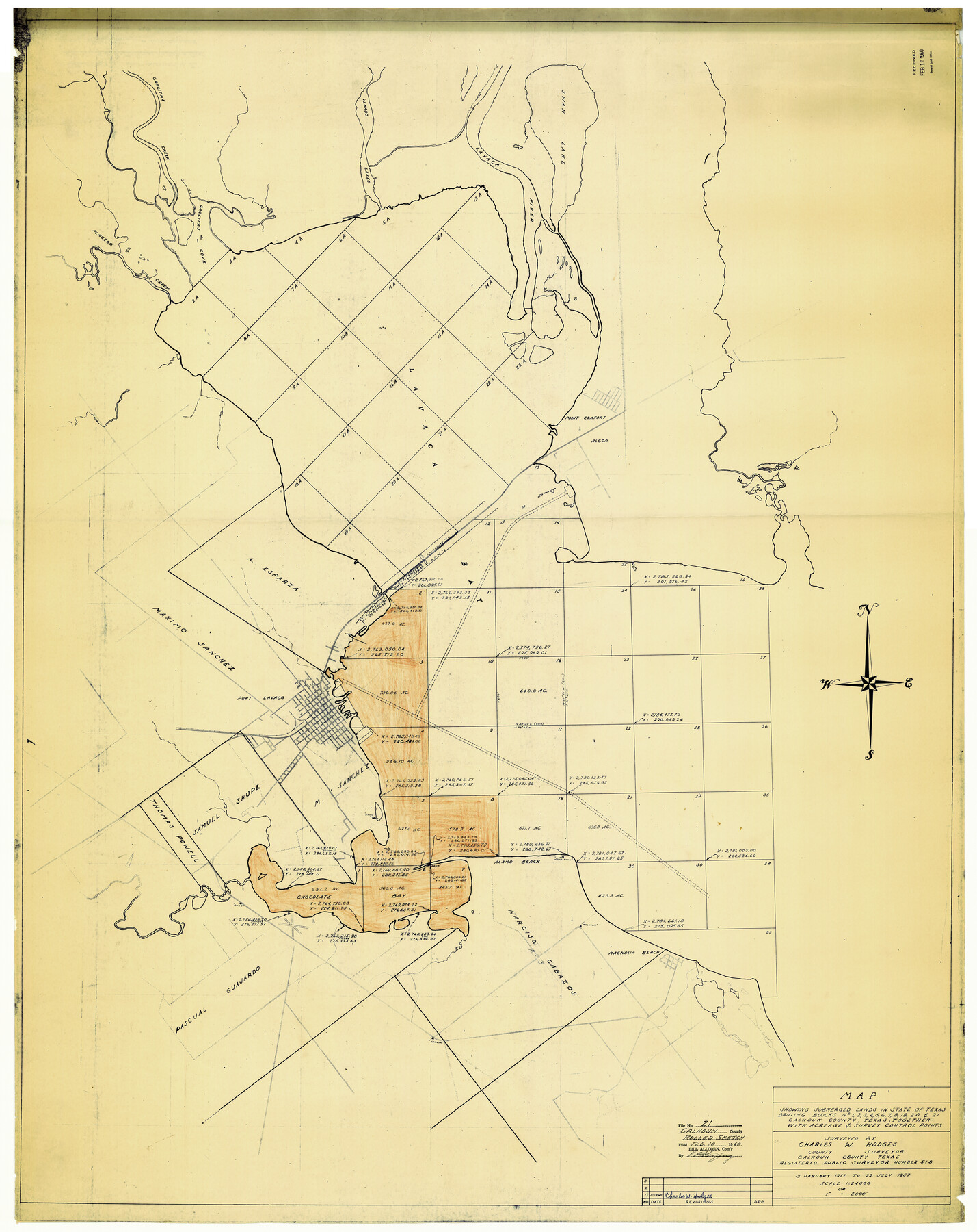
Calhoun County Rolled Sketch 21
Map showing submerged lands in State of Texas Drilling Blocks No. 1, 2, 3, 4, 5, 6, 7, 8, 18, 20 & 21, Calhoun County, Texas, together with acreage & survey control points
-
Map/Doc
8551
-
Collection
General Map Collection
-
Object Dates
7/29/1957 (Creation Date)
2/10/1960 (File Date)
-
People and Organizations
Charles W. Hodges (Surveyor/Engineer)
-
Counties
Calhoun
-
Subjects
Surveying Rolled Sketch
-
Height x Width
47.2 x 37.5 inches
119.9 x 95.3 cm
-
Medium
blueprint/diazo
-
Scale
1" = 2000 feet
Part of: General Map Collection
Flight Mission No. DIX-10P, Frame 67, Aransas County

Print $20.00
- Digital $50.00
Flight Mission No. DIX-10P, Frame 67, Aransas County
1956
Size 18.7 x 22.3 inches
Map/Doc 83928
Flight Mission No. BQR-4K, Frame 68, Brazoria County

Print $20.00
- Digital $50.00
Flight Mission No. BQR-4K, Frame 68, Brazoria County
1952
Size 18.7 x 22.4 inches
Map/Doc 84001
Trinity County Working Sketch Graphic Index

Print $20.00
- Digital $50.00
Trinity County Working Sketch Graphic Index
1946
Size 41.3 x 41.6 inches
Map/Doc 76718
Flight Mission No. CGI-4N, Frame 189, Cameron County

Print $20.00
- Digital $50.00
Flight Mission No. CGI-4N, Frame 189, Cameron County
1955
Size 18.5 x 22.2 inches
Map/Doc 84692
Map of the Western Part of Bexar District

Print $40.00
- Digital $50.00
Map of the Western Part of Bexar District
1849
Size 63.7 x 36.2 inches
Map/Doc 87376
Young County Sketch File 8a

Print $4.00
- Digital $50.00
Young County Sketch File 8a
1858
Size 9.8 x 8.0 inches
Map/Doc 40862
Burnet County Boundary File 3

Print $18.00
- Digital $50.00
Burnet County Boundary File 3
Size 12.8 x 8.2 inches
Map/Doc 50863
Zavala County Rolled Sketch 21

Print $20.00
- Digital $50.00
Zavala County Rolled Sketch 21
Size 27.6 x 38.4 inches
Map/Doc 8324
Map of the Fort Worth & Denver City Railway, Oldham County, Texas

Print $40.00
- Digital $50.00
Map of the Fort Worth & Denver City Railway, Oldham County, Texas
1887
Size 24.8 x 105.2 inches
Map/Doc 64456
Flight Mission No. DAG-16K, Frame 72, Matagorda County

Print $20.00
- Digital $50.00
Flight Mission No. DAG-16K, Frame 72, Matagorda County
1952
Size 16.5 x 16.4 inches
Map/Doc 86318
Fort Bend County Boundary File 1

Print $80.00
- Digital $50.00
Fort Bend County Boundary File 1
Size 25.0 x 69.7 inches
Map/Doc 53553
Loving County Working Sketch 11

Print $40.00
- Digital $50.00
Loving County Working Sketch 11
1957
Size 21.2 x 120.7 inches
Map/Doc 70643
You may also like
Red River, Bois D'Arc Creek Floodway Sheet No. 8

Print $20.00
- Digital $50.00
Red River, Bois D'Arc Creek Floodway Sheet No. 8
1928
Size 17.6 x 24.8 inches
Map/Doc 65272
[The Frisco Line - St. Louis & San Francisco Railway through the Great West and South West]
![95794, [The Frisco Line - St. Louis & San Francisco Railway through the Great West and South West], Cobb Digital Map Collection - 1](https://historictexasmaps.com/wmedia_w700/maps/95794.tif.jpg)
Print $20.00
- Digital $50.00
[The Frisco Line - St. Louis & San Francisco Railway through the Great West and South West]
1893
Size 16.8 x 40.2 inches
Map/Doc 95794
Brewster County Sketch File 49

Print $26.00
- Digital $50.00
Brewster County Sketch File 49
1994
Size 14.2 x 8.8 inches
Map/Doc 16329
Mills County Working Sketch 28

Print $40.00
- Digital $50.00
Mills County Working Sketch 28
2006
Size 42.0 x 67.4 inches
Map/Doc 85385
General Highway Map, Jefferson County, Texas

Print $20.00
General Highway Map, Jefferson County, Texas
1961
Size 24.6 x 18.3 inches
Map/Doc 79537
[Marion County School Land, Jack County School Land, Abel A. Lewis and other surveys in vicinity]
![90427, [Marion County School Land, Jack County School Land, Abel A. Lewis and other surveys in vicinity], Twichell Survey Records](https://historictexasmaps.com/wmedia_w700/maps/90427-1.tif.jpg)
Print $20.00
- Digital $50.00
[Marion County School Land, Jack County School Land, Abel A. Lewis and other surveys in vicinity]
Size 22.0 x 25.1 inches
Map/Doc 90427
Flight Mission No. CGI-3N, Frame 132, Cameron County

Print $20.00
- Digital $50.00
Flight Mission No. CGI-3N, Frame 132, Cameron County
1954
Size 18.4 x 22.2 inches
Map/Doc 84605
Palo Pinto County Working Sketch 17

Print $40.00
- Digital $50.00
Palo Pinto County Working Sketch 17
1974
Size 30.0 x 53.8 inches
Map/Doc 71400
Webb County Working Sketch 83

Print $20.00
- Digital $50.00
Webb County Working Sketch 83
1980
Size 20.7 x 34.9 inches
Map/Doc 72450
Lubbock County Boundary File 4

Print $4.00
- Digital $50.00
Lubbock County Boundary File 4
Size 11.2 x 8.8 inches
Map/Doc 56491
Harris County Working Sketch 20

Print $20.00
- Digital $50.00
Harris County Working Sketch 20
1923
Size 11.7 x 12.4 inches
Map/Doc 65912
Pecos County Working Sketch 45

Print $20.00
- Digital $50.00
Pecos County Working Sketch 45
1946
Size 20.8 x 26.7 inches
Map/Doc 71517