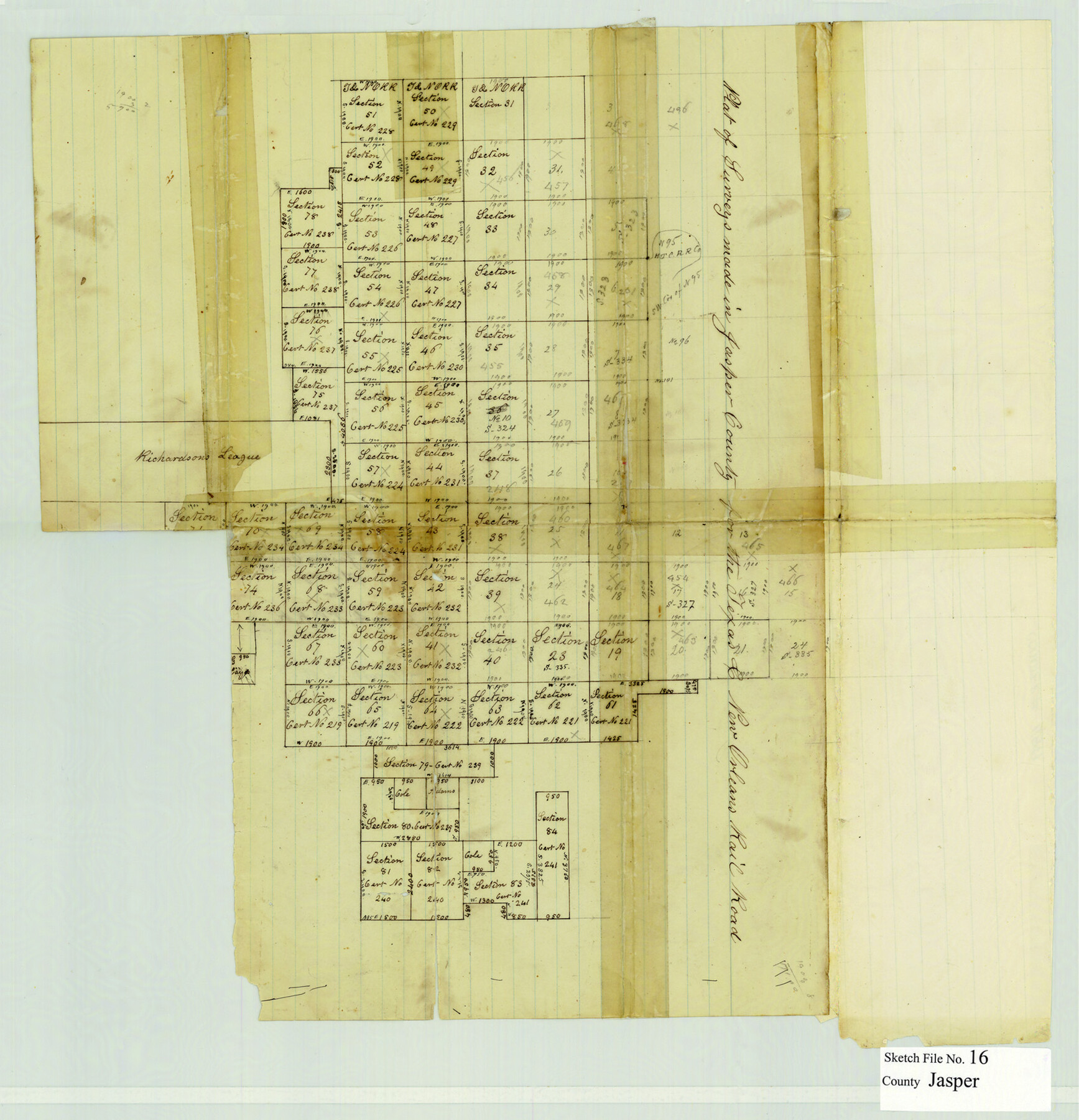
Jasper County Sketch File 16
Plat of Surveys made in Jasper County for the Texas & New Orleans Rail Road
-
Map/Doc
11849
-
Collection
General Map Collection
-
Counties
Jasper
-
Subjects
Surveying Sketch File
-
Height x Width
16.8 x 16.2 inches
42.7 x 41.1 cm
-
Medium
paper, manuscript
Part of: General Map Collection
Webb County Rolled Sketch 79

Print $20.00
- Digital $50.00
Webb County Rolled Sketch 79
2020
Size 35.7 x 24.9 inches
Map/Doc 95916
Reagan County Working Sketch 39

Print $20.00
- Digital $50.00
Reagan County Working Sketch 39
1971
Size 22.5 x 36.1 inches
Map/Doc 71881
Harris County Sketch File 110

Print $26.00
- Digital $50.00
Harris County Sketch File 110
2009
Size 11.0 x 8.5 inches
Map/Doc 89586
Ward County Sketch File 11

Print $20.00
- Digital $50.00
Ward County Sketch File 11
1943
Size 17.4 x 20.4 inches
Map/Doc 12600
Tom Green County Sketch File 70

Print $6.00
- Digital $50.00
Tom Green County Sketch File 70
1945
Size 11.3 x 8.9 inches
Map/Doc 38241
Nueces County Sketch File 18

Print $4.00
- Digital $50.00
Nueces County Sketch File 18
1874
Size 10.2 x 7.2 inches
Map/Doc 32549
Val Verde County Working Sketch 20

Print $20.00
- Digital $50.00
Val Verde County Working Sketch 20
1929
Size 30.5 x 20.2 inches
Map/Doc 72155
Floyd County Sketch File 23

Print $8.00
- Digital $50.00
Floyd County Sketch File 23
1914
Size 11.6 x 9.0 inches
Map/Doc 22776
Erath County Working Sketch 25

Print $20.00
- Digital $50.00
Erath County Working Sketch 25
1968
Size 26.8 x 20.3 inches
Map/Doc 69106
Located Line of the Panhandle & Gulf Ry. through State Lands, Public School and University, Right of Way 200 feet wide, in Brewster County, Texas.

Print $40.00
- Digital $50.00
Located Line of the Panhandle & Gulf Ry. through State Lands, Public School and University, Right of Way 200 feet wide, in Brewster County, Texas.
1904
Size 14.8 x 99.1 inches
Map/Doc 64059
Hardin County Sketch File 58

Print $6.00
- Digital $50.00
Hardin County Sketch File 58
1929
Size 14.3 x 11.5 inches
Map/Doc 25230
Matagorda County NRC Article 33.136 Sketch 17

Print $24.00
Matagorda County NRC Article 33.136 Sketch 17
2023
Map/Doc 97274
You may also like
Concho County Boundary File 2

Print $30.00
- Digital $50.00
Concho County Boundary File 2
Size 12.7 x 8.3 inches
Map/Doc 51814
[Plat of Survey 1, Block B]
![91448, [Plat of Survey 1, Block B], Twichell Survey Records](https://historictexasmaps.com/wmedia_w700/maps/91448-1.tif.jpg)
Print $3.00
- Digital $50.00
[Plat of Survey 1, Block B]
1907
Size 11.7 x 12.6 inches
Map/Doc 91448
Harris County Working Sketch 14

Print $20.00
- Digital $50.00
Harris County Working Sketch 14
Size 18.9 x 17.4 inches
Map/Doc 65906
Sketch from the map of Bailey Co.

Print $2.00
- Digital $50.00
Sketch from the map of Bailey Co.
Size 8.4 x 7.6 inches
Map/Doc 464
Seymour, Baylor County, Texas

Print $20.00
Seymour, Baylor County, Texas
1890
Size 15.4 x 24.2 inches
Map/Doc 89207
Kleberg County Rolled Sketch 10-42

Print $20.00
- Digital $50.00
Kleberg County Rolled Sketch 10-42
1952
Size 42.7 x 36.4 inches
Map/Doc 9380
Starr County Sketch File 32B

Print $20.00
- Digital $50.00
Starr County Sketch File 32B
1938
Size 19.9 x 21.5 inches
Map/Doc 12336
Taylor County Rolled Sketch 28

Print $20.00
- Digital $50.00
Taylor County Rolled Sketch 28
Size 34.4 x 23.9 inches
Map/Doc 7921
Flight Mission No. DIX-5P, Frame 107, Aransas County

Print $20.00
- Digital $50.00
Flight Mission No. DIX-5P, Frame 107, Aransas County
1956
Size 17.6 x 17.8 inches
Map/Doc 83785
Texas 1971 Official State Highway Map

Digital $50.00
Texas 1971 Official State Highway Map
Size 28.3 x 36.5 inches
Map/Doc 94316
Crockett County Working Sketch 13

Print $20.00
- Digital $50.00
Crockett County Working Sketch 13
1916
Size 16.6 x 18.5 inches
Map/Doc 68346
Brewster County Sketch File N-19

Print $40.00
- Digital $50.00
Brewster County Sketch File N-19
1946
Size 18.7 x 26.2 inches
Map/Doc 10966