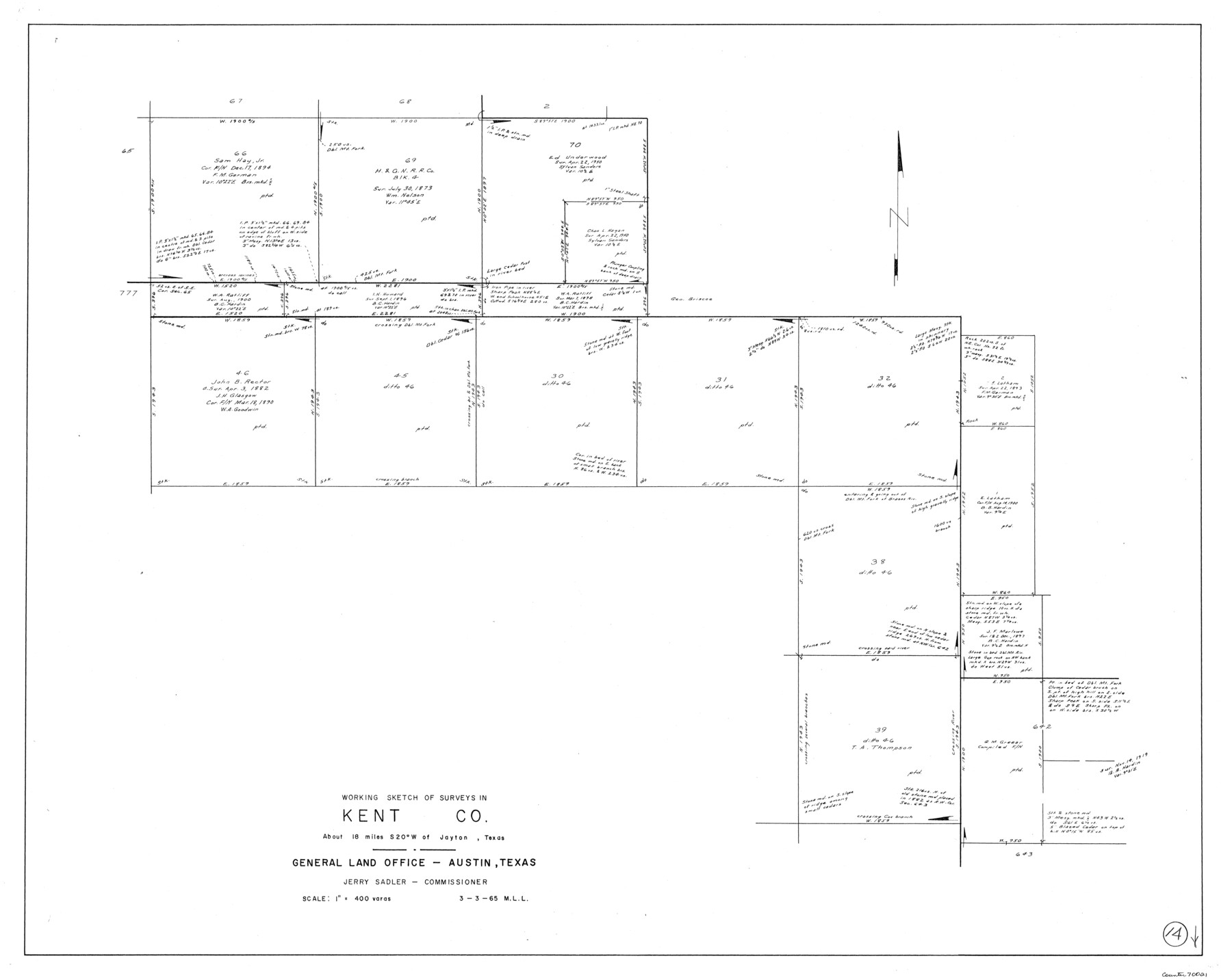
Kent County Working Sketch 14
-
Map/Doc
70021
-
Collection
General Map Collection
-
Object Dates
3/3/1965 (Creation Date)
-
People and Organizations
M. L. Liles (Draftsman)
-
Counties
Kent
-
Subjects
Surveying Working Sketch
-
Height x Width
28.2 x 35.4 inches
71.6 x 89.9 cm
-
Scale
1" = 400 varas
Part of: General Map Collection
Fisher County Boundary File 3a

Print $20.00
- Digital $50.00
Fisher County Boundary File 3a
Size 25.1 x 26.0 inches
Map/Doc 53444
Jim Hogg County Boundary File 2

Print $4.00
- Digital $50.00
Jim Hogg County Boundary File 2
Size 10.6 x 8.7 inches
Map/Doc 55527
Nueces County Rolled Sketch 68

Print $20.00
- Digital $50.00
Nueces County Rolled Sketch 68
1980
Size 19.9 x 25.4 inches
Map/Doc 6919
Map of Ramsey State Farm

Print $20.00
- Digital $50.00
Map of Ramsey State Farm
1934
Size 30.3 x 38.0 inches
Map/Doc 94284
Upton County Rolled Sketch 12

Print $20.00
- Digital $50.00
Upton County Rolled Sketch 12
Size 30.3 x 38.3 inches
Map/Doc 10036
Pecos County Working Sketch 12

Print $20.00
- Digital $50.00
Pecos County Working Sketch 12
1912
Size 21.3 x 30.0 inches
Map/Doc 71482
Flight Mission No. CRC-3R, Frame 7, Chambers County

Print $20.00
- Digital $50.00
Flight Mission No. CRC-3R, Frame 7, Chambers County
1956
Size 18.6 x 22.3 inches
Map/Doc 84781
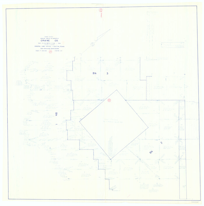
Crane County Working Sketch 28
Print $40.00
- Digital $50.00
Crane County Working Sketch 28
1972
Size 49.4 x 49.1 inches
Map/Doc 68305
Intracoastal Waterway - Laguna Madre - Chubby Island to Stover Point including the Arroyo Colorado, Texas

Print $20.00
- Digital $50.00
Intracoastal Waterway - Laguna Madre - Chubby Island to Stover Point including the Arroyo Colorado, Texas
1976
Size 15.6 x 43.8 inches
Map/Doc 75900
Harris County Working Sketch 37

Print $20.00
- Digital $50.00
Harris County Working Sketch 37
1938
Size 25.4 x 28.0 inches
Map/Doc 65929
Flight Mission No. BQY-15M, Frame 16, Harris County

Print $20.00
- Digital $50.00
Flight Mission No. BQY-15M, Frame 16, Harris County
1953
Size 18.6 x 22.4 inches
Map/Doc 85314
Flight Mission No. BRE-2P, Frame 81, Nueces County

Print $20.00
- Digital $50.00
Flight Mission No. BRE-2P, Frame 81, Nueces County
1956
Size 18.6 x 22.5 inches
Map/Doc 86776
You may also like
Edwards County Working Sketch 62

Print $20.00
- Digital $50.00
Edwards County Working Sketch 62
1955
Size 21.7 x 28.5 inches
Map/Doc 68938

Hopkins County Sketch File 9

Print $6.00
- Digital $50.00
Hopkins County Sketch File 9
1856
Size 12.8 x 8.3 inches
Map/Doc 26697
Hidalgo County Sketch File 10

Print $20.00
- Digital $50.00
Hidalgo County Sketch File 10
1911
Size 16.3 x 34.8 inches
Map/Doc 11762
Wise County Sketch File 53

Print $12.00
- Digital $50.00
Wise County Sketch File 53
2007
Size 8.5 x 14.0 inches
Map/Doc 87360
General Highway Map, Yoakum County, Texas

Print $20.00
General Highway Map, Yoakum County, Texas
1940
Size 18.3 x 24.9 inches
Map/Doc 79285
Flight Mission No. DQN-2K, Frame 78, Calhoun County

Print $20.00
- Digital $50.00
Flight Mission No. DQN-2K, Frame 78, Calhoun County
1953
Size 18.6 x 22.3 inches
Map/Doc 84270
Flight Mission No. CRC-4R, Frame 109, Chambers County

Print $20.00
- Digital $50.00
Flight Mission No. CRC-4R, Frame 109, Chambers County
1956
Size 18.5 x 22.5 inches
Map/Doc 84906
Smith County Working Sketch 9

Print $40.00
- Digital $50.00
Smith County Working Sketch 9
1947
Size 48.8 x 44.2 inches
Map/Doc 63894
Shelby County Working Sketch 3

Print $20.00
- Digital $50.00
Shelby County Working Sketch 3
1940
Size 28.9 x 19.4 inches
Map/Doc 63856
Schleicher County Sketch File 5

Print $40.00
- Digital $50.00
Schleicher County Sketch File 5
Size 17.2 x 13.4 inches
Map/Doc 36470
Liberty County Sketch File 66

Print $10.00
- Digital $50.00
Liberty County Sketch File 66
1900
Size 10.8 x 7.1 inches
Map/Doc 30130