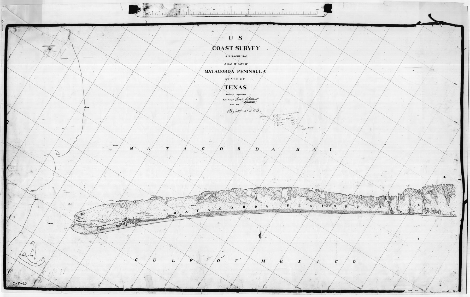
A Map of Part of Matagorda Peninsula, State of Texas
C-7-15
-
Map/Doc
69980
-
Collection
General Map Collection
-
Object Dates
1856 (Creation Date)
-
Counties
Matagorda Calhoun
-
Subjects
Nautical Charts
-
Height x Width
34.4 x 54.2 inches
87.4 x 137.7 cm
Part of: General Map Collection
Flight Mission No. DAG-14K, Frame 142, Matagorda County

Print $20.00
- Digital $50.00
Flight Mission No. DAG-14K, Frame 142, Matagorda County
1952
Size 16.5 x 16.4 inches
Map/Doc 86309
Map of Prison Properties in Vicinity of Huntsville, Walker County, Texas

Print $20.00
- Digital $50.00
Map of Prison Properties in Vicinity of Huntsville, Walker County, Texas
1933
Size 36.6 x 43.0 inches
Map/Doc 62992
Shackelford County Sketch File 1

Print $4.00
- Digital $50.00
Shackelford County Sketch File 1
1877
Size 12.8 x 8.0 inches
Map/Doc 36570
McCulloch County Rolled Sketch 7

Print $20.00
- Digital $50.00
McCulloch County Rolled Sketch 7
1982
Size 20.7 x 30.5 inches
Map/Doc 6718
Harris County Working Sketch 83

Print $20.00
- Digital $50.00
Harris County Working Sketch 83
1970
Size 26.0 x 30.1 inches
Map/Doc 65975
Ellis County Sketch File 23

Print $4.00
- Digital $50.00
Ellis County Sketch File 23
1873
Size 10.3 x 8.3 inches
Map/Doc 21881
Cass County Rolled Sketch OPD

Print $20.00
- Digital $50.00
Cass County Rolled Sketch OPD
1936
Size 29.6 x 24.9 inches
Map/Doc 5415
Map of the Western Territory &c.

Print $20.00
- Digital $50.00
Map of the Western Territory &c.
1834
Size 18.5 x 18.8 inches
Map/Doc 95691
Guadalupe County Sketch File 16

Print $22.00
- Digital $50.00
Guadalupe County Sketch File 16
Size 15.7 x 12.4 inches
Map/Doc 24694
Real County Rolled Sketch 9

Print $20.00
- Digital $50.00
Real County Rolled Sketch 9
1967
Size 33.4 x 40.6 inches
Map/Doc 9834
Northern Part of Laguna Madre

Print $20.00
- Digital $50.00
Northern Part of Laguna Madre
1965
Size 43.9 x 34.6 inches
Map/Doc 73527
[Map showing resurvey of Capitol Leagues in Hartley & Dallam Counties, Texas]
![1753, [Map showing resurvey of Capitol Leagues in Hartley & Dallam Counties, Texas], General Map Collection](https://historictexasmaps.com/wmedia_w700/maps/1753-1.tif.jpg)
Print $40.00
- Digital $50.00
[Map showing resurvey of Capitol Leagues in Hartley & Dallam Counties, Texas]
1918
Size 66.9 x 31.0 inches
Map/Doc 1753
You may also like
Preliminary Sketch of Galveston Bay Indicating Proposed Sites for Light Houses

Print $20.00
Preliminary Sketch of Galveston Bay Indicating Proposed Sites for Light Houses
1851
Size 20.7 x 18.0 inches
Map/Doc 76215
Foard County Working Sketch 5a

Print $20.00
- Digital $50.00
Foard County Working Sketch 5a
1942
Size 18.4 x 24.2 inches
Map/Doc 69195
A Map of the Cotton Kingdom and its Dependencies in America

Print $20.00
- Digital $50.00
A Map of the Cotton Kingdom and its Dependencies in America
1861
Size 12.2 x 18.6 inches
Map/Doc 96573
Smith County Working Sketch 1

Print $20.00
- Digital $50.00
Smith County Working Sketch 1
Size 16.3 x 13.0 inches
Map/Doc 63886
Summer and Winter Health and Pleasure Resorts

Summer and Winter Health and Pleasure Resorts
1890
Size 7.7 x 5.6 inches
Map/Doc 97076
[River Secs. 55-79, Archer County School Land League 3 and surrounding surveys]
![90472, [River Secs. 55-79, Archer County School Land League 3 and surrounding surveys], Twichell Survey Records](https://historictexasmaps.com/wmedia_w700/maps/90472-1.tif.jpg)
Print $20.00
- Digital $50.00
[River Secs. 55-79, Archer County School Land League 3 and surrounding surveys]
Size 28.3 x 20.4 inches
Map/Doc 90472
Zapata County Rolled Sketch 26

Print $20.00
- Digital $50.00
Zapata County Rolled Sketch 26
1982
Size 43.0 x 30.7 inches
Map/Doc 8319
Polk County Rolled Sketch 34

Print $20.00
- Digital $50.00
Polk County Rolled Sketch 34
2023
Size 23.9 x 36.2 inches
Map/Doc 97193
Angelina County Working Sketch 4

Print $20.00
- Digital $50.00
Angelina County Working Sketch 4
1910
Size 15.0 x 13.3 inches
Map/Doc 67084
Hays County Boundary File 2

Print $40.00
- Digital $50.00
Hays County Boundary File 2
Size 6.9 x 26.1 inches
Map/Doc 54593
Coryell County Boundary File 1 and 1a

Print $8.00
- Digital $50.00
Coryell County Boundary File 1 and 1a
Size 8.2 x 3.3 inches
Map/Doc 51890
East Line of Lipscomb County

Print $20.00
- Digital $50.00
East Line of Lipscomb County
Size 8.9 x 21.7 inches
Map/Doc 91317