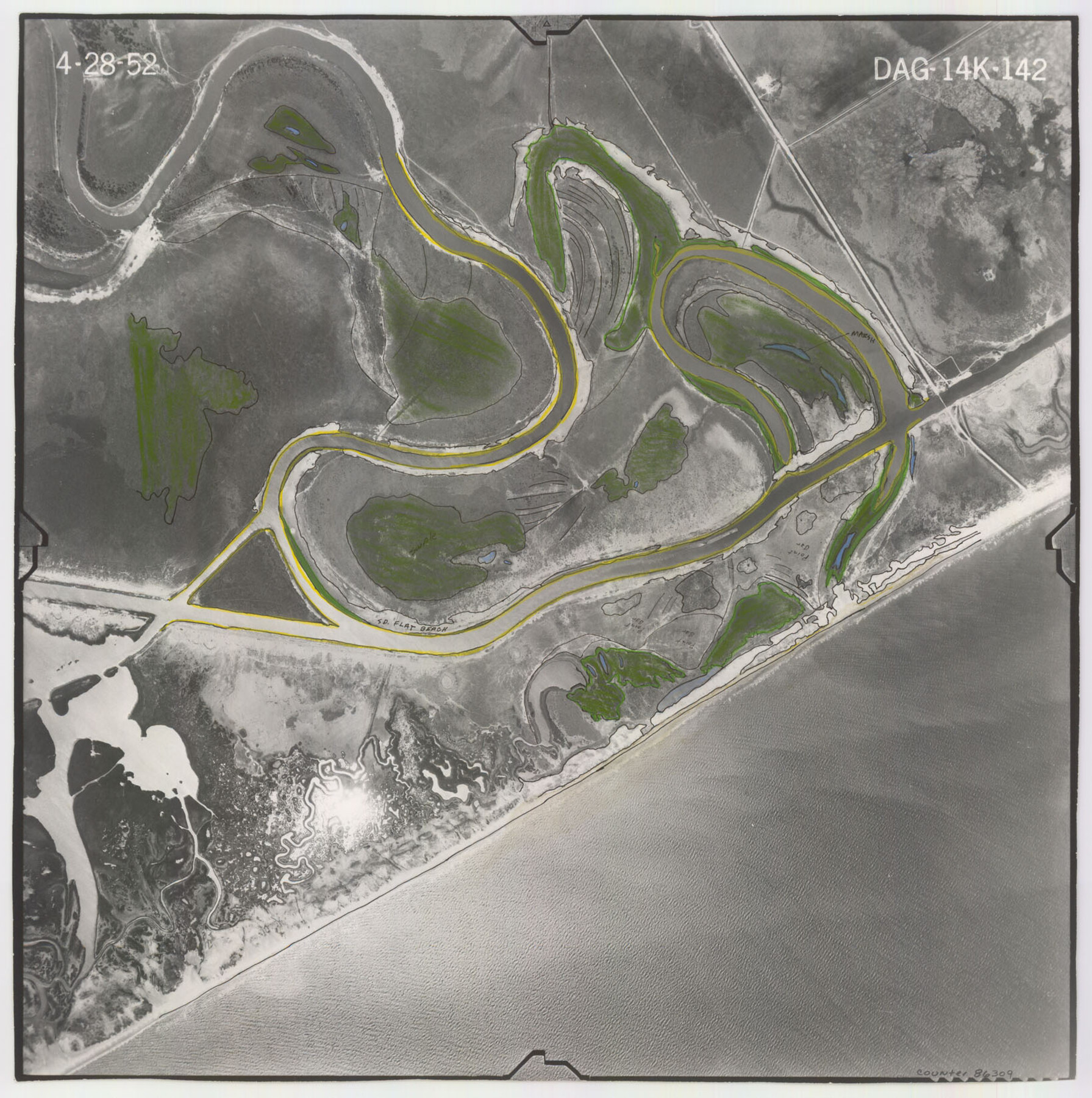
Flight Mission No. DAG-14K, Frame 142, Matagorda County
DAG-14K-142
-
Map/Doc
86309
-
Collection
General Map Collection
-
Object Dates
1952/4/28 (Creation Date)
-
People and Organizations
U. S. Department of Agriculture (Publisher)
-
Counties
Matagorda
-
Subjects
Aerial Photograph
-
Height x Width
16.5 x 16.4 inches
41.9 x 41.7 cm
-
Comments
Flown by Aero Exploration Company of Tulsa, Oklahoma.
Part of: General Map Collection

Nolan County Working Sketch 2

Print $20.00
- Digital $50.00
Nolan County Working Sketch 2
1943
Size 26.7 x 25.0 inches
Map/Doc 71293
Dickens County Sketch File 6a

Print $6.00
- Digital $50.00
Dickens County Sketch File 6a
1882
Size 16.5 x 9.4 inches
Map/Doc 20969
Travis County Sketch File 39

Print $20.00
- Digital $50.00
Travis County Sketch File 39
1914
Size 15.5 x 25.7 inches
Map/Doc 12463
Webb County Working Sketch 59

Print $20.00
- Digital $50.00
Webb County Working Sketch 59
1960
Size 25.0 x 32.2 inches
Map/Doc 72425
Wise County Rolled Sketch 7

Print $20.00
- Digital $50.00
Wise County Rolled Sketch 7
Size 23.9 x 18.4 inches
Map/Doc 8281
Flight Mission No. CGI-3N, Frame 166, Cameron County

Print $20.00
- Digital $50.00
Flight Mission No. CGI-3N, Frame 166, Cameron County
1954
Size 18.6 x 22.2 inches
Map/Doc 84630
Orange County Rolled Sketch 23

Print $20.00
- Digital $50.00
Orange County Rolled Sketch 23
1950
Size 29.0 x 35.3 inches
Map/Doc 7185
Map of Throckmorton County Young Land District

Print $20.00
- Digital $50.00
Map of Throckmorton County Young Land District
1859
Size 25.2 x 20.3 inches
Map/Doc 4078
Denton County Working Sketch 23

Print $20.00
- Digital $50.00
Denton County Working Sketch 23
1982
Size 18.6 x 14.1 inches
Map/Doc 68628
Galveston County Sketch File 66

Print $116.00
- Digital $50.00
Galveston County Sketch File 66
Size 5.0 x 10.0 inches
Map/Doc 23751
Map of Limestone County
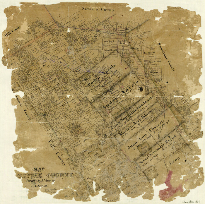
Print $20.00
- Digital $50.00
Map of Limestone County
1869
Size 22.1 x 22.4 inches
Map/Doc 3818
You may also like
Township No. 1 South Range No. 21 West of the Indian Meridian

Print $20.00
- Digital $50.00
Township No. 1 South Range No. 21 West of the Indian Meridian
1875
Size 19.2 x 24.5 inches
Map/Doc 75178
Upper Galveston Bay, Houston Ship Channel, Dollar Pt. to Atkinson I.

Print $40.00
- Digital $50.00
Upper Galveston Bay, Houston Ship Channel, Dollar Pt. to Atkinson I.
1972
Size 49.9 x 36.9 inches
Map/Doc 69895
Map of Denton County

Print $20.00
- Digital $50.00
Map of Denton County
1897
Size 42.7 x 39.5 inches
Map/Doc 4932
F. W. & D. C. Ry. Co. Alignment and Right of Way Map, Clay County

Print $20.00
- Digital $50.00
F. W. & D. C. Ry. Co. Alignment and Right of Way Map, Clay County
1927
Size 11.8 x 18.7 inches
Map/Doc 64744
Travis County

Print $40.00
- Digital $50.00
Travis County
1963
Size 37.7 x 50.7 inches
Map/Doc 73597
G. C. & S. F. Ry., San Saba Branch, Right of Way Map, Brady to Melvin

Print $20.00
- Digital $50.00
G. C. & S. F. Ry., San Saba Branch, Right of Way Map, Brady to Melvin
1916
Size 36.9 x 23.0 inches
Map/Doc 61422
Culberson County Working Sketch 44

Print $40.00
- Digital $50.00
Culberson County Working Sketch 44
1970
Size 53.4 x 36.4 inches
Map/Doc 68498
Right of Way & Track Map Houston & Brazos Valley Ry. operated by Houston & Brazos Valley Ry. Co., Hoskins Mound Branch

Print $40.00
- Digital $50.00
Right of Way & Track Map Houston & Brazos Valley Ry. operated by Houston & Brazos Valley Ry. Co., Hoskins Mound Branch
1924
Size 25.0 x 56.6 inches
Map/Doc 64610
Map of Bexar County

Print $40.00
- Digital $50.00
Map of Bexar County
1845
Size 48.8 x 43.0 inches
Map/Doc 87237
[Map of Santa Fe Route - Atchison, Topeka, and Santa Fe Railroad]
![95866, [Map of Santa Fe Route - Atchison, Topeka, and Santa Fe Railroad], Cobb Digital Map Collection - 1](https://historictexasmaps.com/wmedia_w700/maps/95866.tif.jpg)
Print $40.00
- Digital $50.00
[Map of Santa Fe Route - Atchison, Topeka, and Santa Fe Railroad]
1893
Size 17.4 x 50.0 inches
Map/Doc 95866
Upton County Rolled Sketch 50

Print $20.00
- Digital $50.00
Upton County Rolled Sketch 50
1959
Size 20.8 x 32.7 inches
Map/Doc 8085
Knox County Rolled Sketch 21

Print $20.00
- Digital $50.00
Knox County Rolled Sketch 21
1955
Size 18.0 x 36.4 inches
Map/Doc 6561