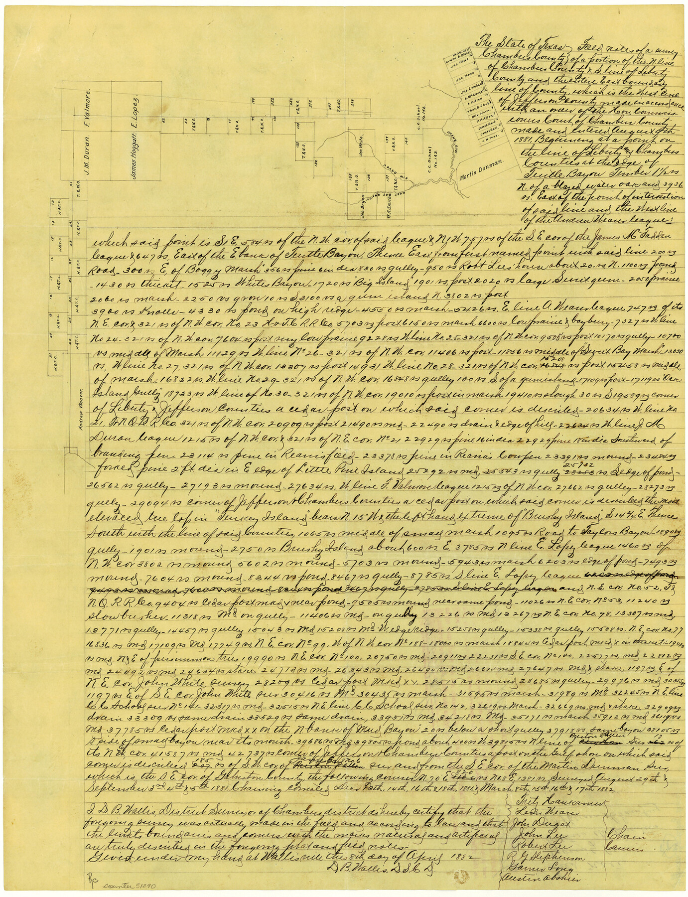
Chambers County Boundary File 50a
Field Notes County Line between the Counties of Jefferson & Chambers
-
Map/Doc
51270
-
Collection
General Map Collection
-
Counties
Chambers
-
Subjects
County Boundaries
-
Height x Width
22.2 x 17.1 inches
56.4 x 43.4 cm
Part of: General Map Collection
Henderson County Working Sketch 16

Print $40.00
- Digital $50.00
Henderson County Working Sketch 16
1937
Size 49.9 x 30.9 inches
Map/Doc 66149

[Right of Way Map, Belton Branch of the M.K.&T. RR.]
![64224, [Right of Way Map, Belton Branch of the M.K.&T. RR.], General Map Collection](https://historictexasmaps.com/wmedia_w700/maps/64224.tif.jpg)
Print $20.00
- Digital $50.00
[Right of Way Map, Belton Branch of the M.K.&T. RR.]
1896
Size 7.1 x 20.6 inches
Map/Doc 64224
Gaines County

Print $40.00
- Digital $50.00
Gaines County
1902
Size 38.9 x 49.7 inches
Map/Doc 66832
Real County Working Sketch 49

Print $20.00
- Digital $50.00
Real County Working Sketch 49
1957
Size 25.9 x 25.7 inches
Map/Doc 71941
Hutchinson County Rolled Sketch 41

Print $40.00
- Digital $50.00
Hutchinson County Rolled Sketch 41
1989
Size 43.3 x 144.5 inches
Map/Doc 9249
Donley County Rolled Sketch 4

Print $20.00
- Digital $50.00
Donley County Rolled Sketch 4
1972
Size 16.0 x 17.4 inches
Map/Doc 5731
Crockett County Working Sketch 30

Print $20.00
- Digital $50.00
Crockett County Working Sketch 30
1924
Size 30.1 x 22.1 inches
Map/Doc 68363

Upton County Sketch File 21

Print $20.00
- Digital $50.00
Upton County Sketch File 21
1927
Size 15.0 x 23.7 inches
Map/Doc 12518
Presidio County Working Sketch 70

Print $20.00
- Digital $50.00
Presidio County Working Sketch 70
1961
Size 46.8 x 37.4 inches
Map/Doc 71747
Nueces County Rolled Sketch 100

Print $20.00
- Digital $50.00
Nueces County Rolled Sketch 100
Size 43.9 x 37.7 inches
Map/Doc 10208
You may also like
Anderson County Boundary File 8

Print $8.00
- Digital $50.00
Anderson County Boundary File 8
Size 14.5 x 8.8 inches
Map/Doc 49755
Red River County Working Sketch 22

Print $20.00
- Digital $50.00
Red River County Working Sketch 22
1955
Size 27.9 x 26.8 inches
Map/Doc 72005
Official Map of the City of Waxahachie, Texas
.tif.jpg)
Print $20.00
- Digital $50.00
Official Map of the City of Waxahachie, Texas
1922
Size 41.4 x 40.8 inches
Map/Doc 4841
Hall County Sketch File 33

Print $16.00
- Digital $50.00
Hall County Sketch File 33
1912
Size 11.4 x 8.7 inches
Map/Doc 24874
Karnes County Rolled Sketch 5

Print $20.00
- Digital $50.00
Karnes County Rolled Sketch 5
1980
Size 40.8 x 40.2 inches
Map/Doc 9668
Brewster County Sketch File NS-4b

Print $40.00
- Digital $50.00
Brewster County Sketch File NS-4b
Size 30.4 x 35.8 inches
Map/Doc 10988
Flight Mission No. DCL-7C, Frame 48, Kenedy County

Print $20.00
- Digital $50.00
Flight Mission No. DCL-7C, Frame 48, Kenedy County
1943
Size 16.6 x 16.5 inches
Map/Doc 86036
J. R. Jameson Farm

Print $2.00
- Digital $50.00
J. R. Jameson Farm
Size 9.1 x 13.9 inches
Map/Doc 92327
General Highway Map. Detail of Cities and Towns in Grimes County, Texas

Print $20.00
General Highway Map. Detail of Cities and Towns in Grimes County, Texas
1961
Size 18.2 x 24.8 inches
Map/Doc 79491

Flight Mission No. CLL-4N, Frame 39, Willacy County

Print $20.00
- Digital $50.00
Flight Mission No. CLL-4N, Frame 39, Willacy County
1954
Size 18.3 x 22.0 inches
Map/Doc 87112
Guadalupe County Sketch File 7b

Print $4.00
- Digital $50.00
Guadalupe County Sketch File 7b
Size 7.3 x 10.9 inches
Map/Doc 24670