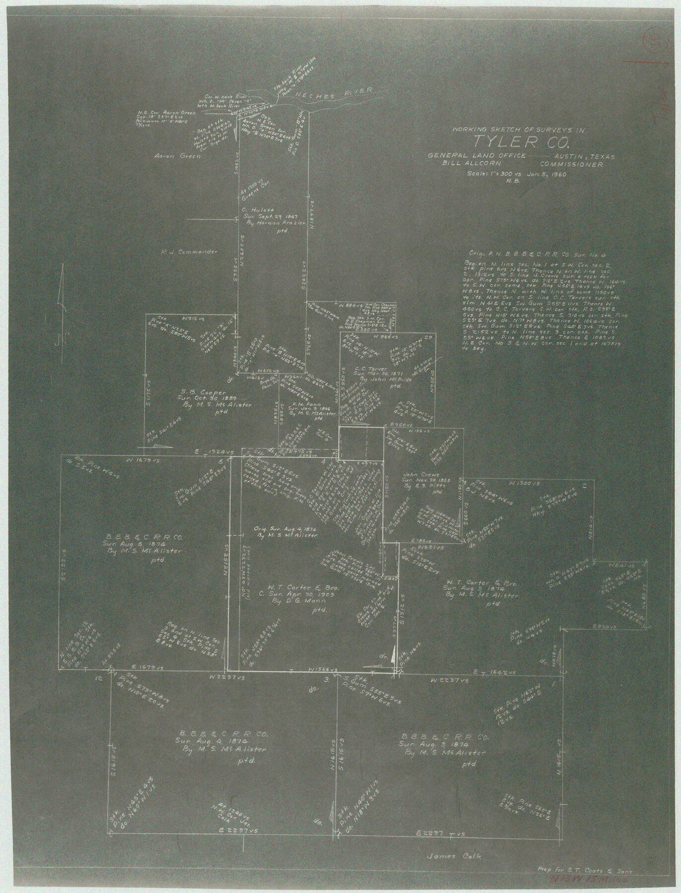
Tyler County Working Sketch 15
-
Map/Doc
69485
-
Collection
General Map Collection
-
Object Dates
1/5/1960 (Creation Date)
-
People and Organizations
Roy Buckholts (Draftsman)
-
Counties
Tyler
-
Subjects
Surveying Working Sketch
-
Height x Width
23.8 x 18.1 inches
60.5 x 46.0 cm
-
Scale
1" = 300 varas
Part of: General Map Collection
Flight Mission No. DQO-8K, Frame 75, Galveston County

Print $20.00
- Digital $50.00
Flight Mission No. DQO-8K, Frame 75, Galveston County
1952
Size 18.7 x 22.5 inches
Map/Doc 85179
Dickens County Working Sketch 9

Print $20.00
- Digital $50.00
Dickens County Working Sketch 9
1947
Size 18.5 x 29.6 inches
Map/Doc 68657
Harrison County Working Sketch 15

Print $20.00
- Digital $50.00
Harrison County Working Sketch 15
1961
Size 25.7 x 18.0 inches
Map/Doc 66035
Nueces River, Corpus Christi Sheet No. 4

Print $20.00
- Digital $50.00
Nueces River, Corpus Christi Sheet No. 4
1938
Size 31.6 x 41.8 inches
Map/Doc 65093
Webb County Working Sketch 67

Print $40.00
- Digital $50.00
Webb County Working Sketch 67
1966
Size 60.9 x 43.7 inches
Map/Doc 72434
Eastland County Working Sketch 63

Print $20.00
- Digital $50.00
Eastland County Working Sketch 63
1997
Size 36.7 x 37.6 inches
Map/Doc 68844
Kinney County Sketch File 36

Print $20.00
- Digital $50.00
Kinney County Sketch File 36
1946
Size 19.2 x 22.0 inches
Map/Doc 11949
Harris County State Real Property Sketch 6

Print $20.00
- Digital $50.00
Harris County State Real Property Sketch 6
Size 23.6 x 35.9 inches
Map/Doc 96641
Howard County

Print $20.00
- Digital $50.00
Howard County
1922
Size 40.3 x 34.6 inches
Map/Doc 77318
Kendall County Working Sketch 17

Print $20.00
- Digital $50.00
Kendall County Working Sketch 17
1968
Size 31.0 x 30.9 inches
Map/Doc 66689
Cass County Rolled Sketch 6

Print $40.00
- Digital $50.00
Cass County Rolled Sketch 6
1957
Size 40.0 x 61.9 inches
Map/Doc 8586
Flight Mission No. DAG-14K, Frame 141, Matagorda County

Print $20.00
- Digital $50.00
Flight Mission No. DAG-14K, Frame 141, Matagorda County
1952
Size 16.4 x 16.3 inches
Map/Doc 86308
You may also like
Map of Tom Green County

Print $20.00
- Digital $50.00
Map of Tom Green County
1892
Size 42.9 x 46.2 inches
Map/Doc 78390
Survey 1, Block 1, D.B. Gardner in Dickens County

Print $20.00
- Digital $50.00
Survey 1, Block 1, D.B. Gardner in Dickens County
1914
Size 14.9 x 30.4 inches
Map/Doc 10767
Lampasas County Sketch File 11

Print $4.00
- Digital $50.00
Lampasas County Sketch File 11
1874
Size 12.2 x 7.9 inches
Map/Doc 29420
Hardin County Working Sketch 3

Print $3.00
- Digital $50.00
Hardin County Working Sketch 3
1906
Size 9.1 x 11.0 inches
Map/Doc 63401
Lubbock County Boundary File 10

Print $108.00
- Digital $50.00
Lubbock County Boundary File 10
Size 14.3 x 8.7 inches
Map/Doc 56549
Winkler County Rolled Sketch CE-1

Print $20.00
- Digital $50.00
Winkler County Rolled Sketch CE-1
1936
Size 36.8 x 35.5 inches
Map/Doc 10149
[Cotton Belt, St. Louis Southwestern Railway of Texas, Alignment through Smith County]
![64374, [Cotton Belt, St. Louis Southwestern Railway of Texas, Alignment through Smith County], General Map Collection](https://historictexasmaps.com/wmedia_w700/maps/64374.tif.jpg)
Print $20.00
- Digital $50.00
[Cotton Belt, St. Louis Southwestern Railway of Texas, Alignment through Smith County]
1903
Size 21.5 x 29.3 inches
Map/Doc 64374
Limestone County Sketch File 20

Print $44.00
- Digital $50.00
Limestone County Sketch File 20
1922
Size 11.2 x 8.5 inches
Map/Doc 30195
Hamilton County Working Sketch 36

Print $40.00
- Digital $50.00
Hamilton County Working Sketch 36
2008
Size 36.9 x 57.3 inches
Map/Doc 88996
Midland County Rolled Sketch 14

Print $40.00
- Digital $50.00
Midland County Rolled Sketch 14
Size 102.9 x 43.8 inches
Map/Doc 73579
Galveston County NRC Article 33.136 Sketch 97

Print $414.00
Galveston County NRC Article 33.136 Sketch 97
2024
Map/Doc 97407
Potter County Sketch File 4

Print $10.00
- Digital $50.00
Potter County Sketch File 4
1882
Size 14.1 x 8.6 inches
Map/Doc 34382