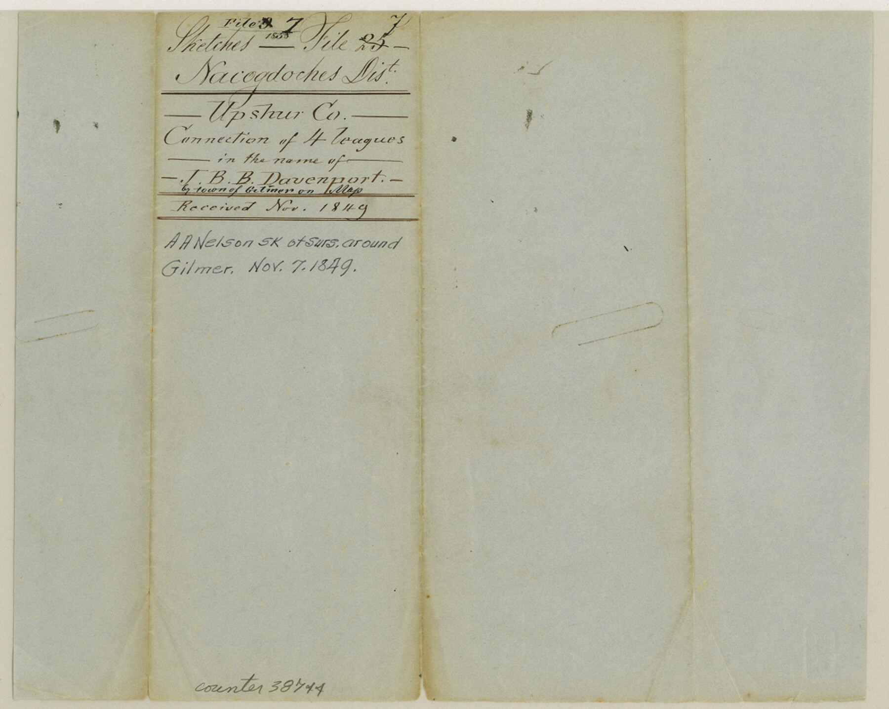
Upshur County Sketch File 7
[Sketch of surveys around Gilmer showing connection of the Davenport four league survey with three one league surveys]
-
Map/Doc
38744
-
Collection
General Map Collection
-
Object Dates
11/7/1849 (Creation Date)
11/1849 (File Date)
-
People and Organizations
A.A. Nelson (Surveyor/Engineer)
-
Counties
Upshur
-
Subjects
Surveying Sketch File
-
Height x Width
8.2 x 10.2 inches
20.8 x 25.9 cm
Part of: General Map Collection
Jasper County Boundary File 4a

Print $20.00
- Digital $50.00
Jasper County Boundary File 4a
Size 36.6 x 17.6 inches
Map/Doc 55491
Map of Clemens State Farm, Brazoria County, Texas

Print $20.00
- Digital $50.00
Map of Clemens State Farm, Brazoria County, Texas
1934
Size 31.2 x 36.1 inches
Map/Doc 62984
Flight Mission No. CLL-1N, Frame 81, Willacy County

Print $20.00
- Digital $50.00
Flight Mission No. CLL-1N, Frame 81, Willacy County
1954
Size 18.3 x 22.1 inches
Map/Doc 87027
Jim Wells County Working Sketch 9

Print $20.00
- Digital $50.00
Jim Wells County Working Sketch 9
1948
Size 34.1 x 38.9 inches
Map/Doc 66607
Kleberg County Rolled Sketch 10-23

Print $20.00
- Digital $50.00
Kleberg County Rolled Sketch 10-23
1953
Size 37.5 x 31.3 inches
Map/Doc 9396
Goliad County Sketch File 18

Print $100.00
- Digital $50.00
Goliad County Sketch File 18
1854
Size 12.8 x 15.5 inches
Map/Doc 24255

Map of the Recognised Line M. EL. P. & P. R. R. from East Line of Bexar Land District to El Paso

Print $20.00
- Digital $50.00
Map of the Recognised Line M. EL. P. & P. R. R. from East Line of Bexar Land District to El Paso
1857
Size 7.5 x 41.8 inches
Map/Doc 2218
Travis County State Real Property Sketch 3

Print $20.00
- Digital $50.00
Travis County State Real Property Sketch 3
1985
Size 34.3 x 35.9 inches
Map/Doc 61694
Jackson County Boundary File 3

Print $10.00
- Digital $50.00
Jackson County Boundary File 3
Size 10.9 x 8.7 inches
Map/Doc 55455
Red River County Working Sketch 62

Print $20.00
- Digital $50.00
Red River County Working Sketch 62
1973
Size 27.1 x 40.0 inches
Map/Doc 72045
Matagorda County NRC Article 33.136 Sketch 9

Print $28.00
- Digital $50.00
Matagorda County NRC Article 33.136 Sketch 9
2011
Size 24.0 x 36.0 inches
Map/Doc 94811
You may also like
Pecos County Sketch

Print $20.00
- Digital $50.00
Pecos County Sketch
1928
Size 38.6 x 21.6 inches
Map/Doc 91616
The Republic County of Matagorda. Proposed, Late Fall 1837-January 1, 1838

Print $20.00
The Republic County of Matagorda. Proposed, Late Fall 1837-January 1, 1838
2020
Size 21.0 x 21.7 inches
Map/Doc 96215
Medina County Working Sketch 32

Print $20.00
- Digital $50.00
Medina County Working Sketch 32
1994
Size 30.4 x 42.4 inches
Map/Doc 70947
Reeves County

Print $20.00
- Digital $50.00
Reeves County
1945
Size 46.4 x 37.3 inches
Map/Doc 77406
Bowie County Sketch File 9

Print $10.00
- Digital $50.00
Bowie County Sketch File 9
Size 8.1 x 3.9 inches
Map/Doc 14907
Nueces River, Corpus Christi Sheet No. 3

Print $6.00
- Digital $50.00
Nueces River, Corpus Christi Sheet No. 3
1938
Size 31.7 x 25.9 inches
Map/Doc 65091
Crockett County Rolled Sketch 82

Print $20.00
- Digital $50.00
Crockett County Rolled Sketch 82
1959
Size 22.4 x 21.2 inches
Map/Doc 5622
Nolan County Boundary File 1

Print $60.00
- Digital $50.00
Nolan County Boundary File 1
Size 8.8 x 3.9 inches
Map/Doc 57617
Angelina County Working Sketch 18

Print $20.00
- Digital $50.00
Angelina County Working Sketch 18
1944
Size 26.6 x 28.8 inches
Map/Doc 67099
Laneer vs. Bivins, Potter County, Texas

Print $20.00
- Digital $50.00
Laneer vs. Bivins, Potter County, Texas
Size 21.7 x 19.0 inches
Map/Doc 93103
Houston, Texas (Looking South)

Print $20.00
Houston, Texas (Looking South)
1891
Size 41.1 x 25.3 inches
Map/Doc 93465
![91112, [Block 1], Twichell Survey Records](https://historictexasmaps.com/wmedia_w700/maps/91112-1.tif.jpg)