Presidio County Sketch File P1
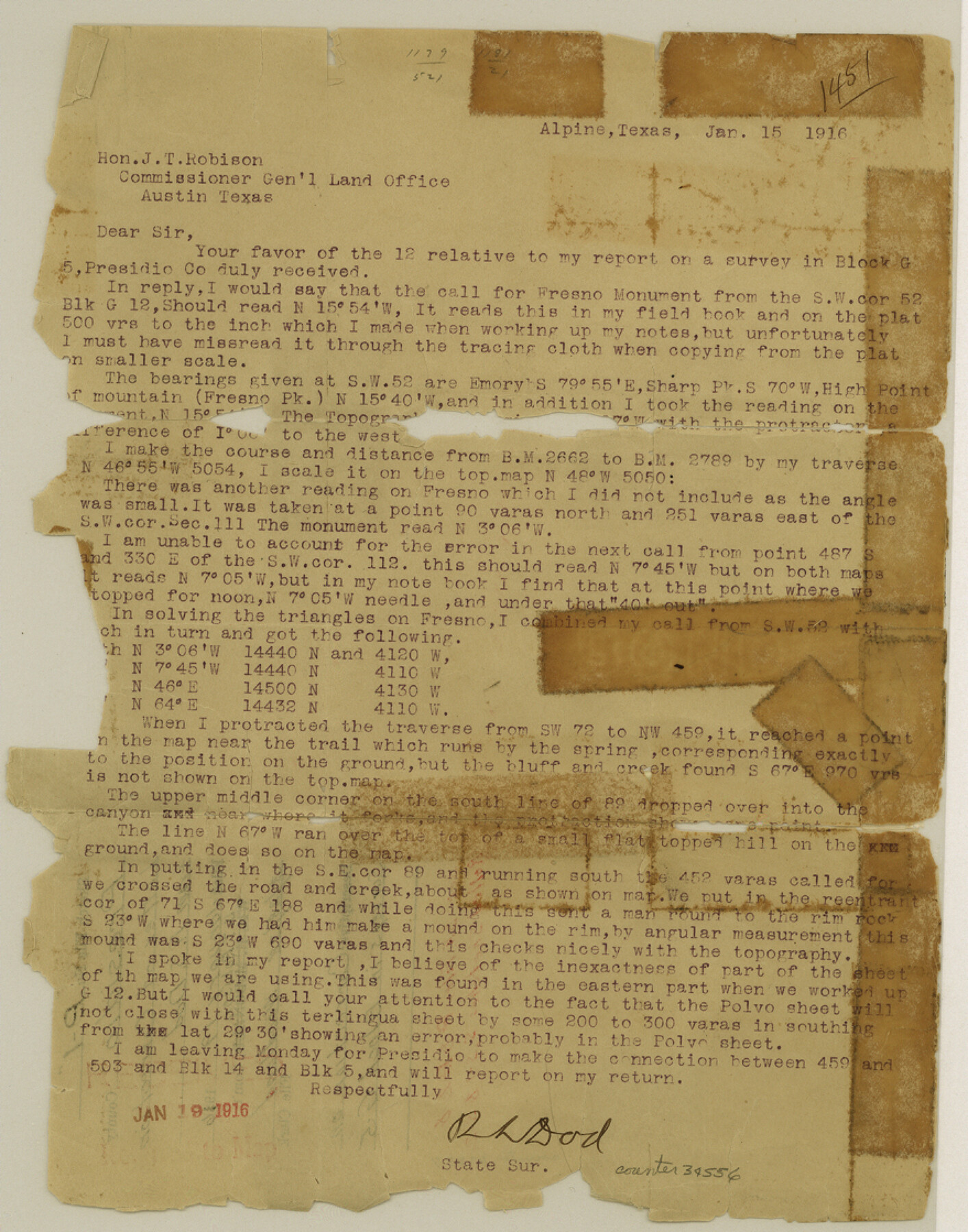
[Letter regarding correction on surveys in Block G5]
-
Map/Doc
34556
-
Collection
General Map Collection
-
Object Dates
1/19/1916 (File Date)
1/15/1916 (Correspondence Date)
-
People and Organizations
R.S. Dod (Surveyor/Engineer)
-
Counties
Presidio
-
Subjects
Surveying Sketch File
-
Height x Width
11.2 x 8.8 inches
28.5 x 22.4 cm
-
Medium
paper, print
-
Comments
See Presidio County Sketch File P (34552) and Presidio County Sketch File P2 (34558) for additional reports and correspondence, and see Presidio County Rolled Sketch S (7413), Presidio County Rolled Sketch S1 (7414), and Presidio County Rolled Sketch S2 (7415) for sketches.
-
Features
Fresno Peak
Related maps
Presidio County Sketch File P

Print $8.00
- Digital $50.00
Presidio County Sketch File P
1916
Size 14.4 x 8.8 inches
Map/Doc 34552
Presidio County Sketch File P2

Print $6.00
- Digital $50.00
Presidio County Sketch File P2
Size 14.3 x 8.9 inches
Map/Doc 34558
Presidio County Rolled Sketch S

Print $20.00
- Digital $50.00
Presidio County Rolled Sketch S
1915
Size 15.6 x 15.4 inches
Map/Doc 7413
Presidio County Rolled Sketch S1

Print $20.00
- Digital $50.00
Presidio County Rolled Sketch S1
Size 13.3 x 18.8 inches
Map/Doc 7414
Presidio County Rolled Sketch S2

Print $20.00
- Digital $50.00
Presidio County Rolled Sketch S2
1916
Size 14.2 x 12.0 inches
Map/Doc 7415
Part of: General Map Collection
Val Verde County Working Sketch 18

Print $20.00
- Digital $50.00
Val Verde County Working Sketch 18
1928
Size 31.4 x 28.3 inches
Map/Doc 72153
Wilbarger County Working Sketch 14

Print $20.00
- Digital $50.00
Wilbarger County Working Sketch 14
1955
Size 24.8 x 21.7 inches
Map/Doc 72552
Lubbock County Sketch File 15

Print $6.00
- Digital $50.00
Lubbock County Sketch File 15
1902
Size 11.2 x 8.8 inches
Map/Doc 30440
Texas, Corpus Christi Bay, Mustang Island

Print $40.00
- Digital $50.00
Texas, Corpus Christi Bay, Mustang Island
1934
Size 49.6 x 35.0 inches
Map/Doc 73462
Carson County Working Sketch 5

Print $20.00
- Digital $50.00
Carson County Working Sketch 5
1979
Size 42.2 x 14.5 inches
Map/Doc 67876
Dallam County Rolled Sketch 8

Print $20.00
- Digital $50.00
Dallam County Rolled Sketch 8
1949
Size 37.7 x 26.3 inches
Map/Doc 5686
Fannin County Boundary File 10a and 10b and 10c

Print $4.00
- Digital $50.00
Fannin County Boundary File 10a and 10b and 10c
Size 11.2 x 9.0 inches
Map/Doc 53328
Map of that part of the boundary between the Republic of Texas and the United States, comprised between Logan's Ferry on the Sabine River and the 36th Mile Mound on the Meridian Line (Sheet No. 1)
![4671, Map of that part of the boundary between the Republic of Texas and the United States, comprised between Logan's Ferry on the Sabine River and the [3]6th Mile Mound on the [Meridian Line] (Sheet No. 1), General Map Collection](https://historictexasmaps.com/wmedia_w700/maps/4671-GC.tif.jpg)
Print $20.00
- Digital $50.00
Map of that part of the boundary between the Republic of Texas and the United States, comprised between Logan's Ferry on the Sabine River and the 36th Mile Mound on the Meridian Line (Sheet No. 1)
1842
Size 34.6 x 26.4 inches
Map/Doc 4671
Flight Mission No. DIX-6P, Frame 180, Aransas County

Print $20.00
- Digital $50.00
Flight Mission No. DIX-6P, Frame 180, Aransas County
1956
Size 19.0 x 22.6 inches
Map/Doc 83842
Crockett County Sketch File 76

Print $2.00
- Digital $50.00
Crockett County Sketch File 76
1933
Size 11.2 x 8.6 inches
Map/Doc 19876
Zavala County Sketch File 15

Print $20.00
- Digital $50.00
Zavala County Sketch File 15
Size 23.3 x 22.3 inches
Map/Doc 12729
San Saba County Sketch File 2

Print $6.00
- Digital $50.00
San Saba County Sketch File 2
1854
Size 4.8 x 7.4 inches
Map/Doc 36405
You may also like
Hemphill County Rolled Sketch 10

Print $20.00
- Digital $50.00
Hemphill County Rolled Sketch 10
Size 19.4 x 27.6 inches
Map/Doc 6192
Freestone County Rolled Sketch 2

Print $20.00
- Digital $50.00
Freestone County Rolled Sketch 2
1952
Size 27.1 x 30.2 inches
Map/Doc 5910
Crockett County Sketch File 75

Print $20.00
- Digital $50.00
Crockett County Sketch File 75
Size 26.3 x 28.8 inches
Map/Doc 11234
Carte Generale du Royaume de la Nouvelle Espagne depuis le Parallele de 16° jusqu'au Parallele de 38° (Latitude Nord)

Print $20.00
- Digital $50.00
Carte Generale du Royaume de la Nouvelle Espagne depuis le Parallele de 16° jusqu'au Parallele de 38° (Latitude Nord)
1804
Size 41.5 x 29.5 inches
Map/Doc 96510
Right of Way and Track Map of The Missouri, Kansas & Texas Railway of Texas

Print $40.00
- Digital $50.00
Right of Way and Track Map of The Missouri, Kansas & Texas Railway of Texas
1918
Size 24.9 x 53.1 inches
Map/Doc 64537
The Chief Justice County of Washington. Undated

Print $20.00
The Chief Justice County of Washington. Undated
2020
Size 13.0 x 21.7 inches
Map/Doc 96077
Township No. 5 South Range No. 10 West of the Indian Meridian

Print $20.00
- Digital $50.00
Township No. 5 South Range No. 10 West of the Indian Meridian
1874
Size 19.2 x 24.5 inches
Map/Doc 75161
Haskell County Working Sketch 7

Print $40.00
- Digital $50.00
Haskell County Working Sketch 7
1956
Size 52.1 x 39.0 inches
Map/Doc 66065
Section J Tech Memorial Park, Inc. Infants Garden

Print $2.00
- Digital $50.00
Section J Tech Memorial Park, Inc. Infants Garden
1949
Size 8.8 x 13.0 inches
Map/Doc 92352
Clay County Sketch File 12

Print $4.00
- Digital $50.00
Clay County Sketch File 12
1873
Size 13.0 x 8.2 inches
Map/Doc 18411
Hutchinson County Rolled Sketch 44-15

Print $20.00
- Digital $50.00
Hutchinson County Rolled Sketch 44-15
2002
Size 24.0 x 36.0 inches
Map/Doc 77551
Atascosa County Rolled Sketch 12

Print $40.00
- Digital $50.00
Atascosa County Rolled Sketch 12
1944
Size 33.3 x 68.8 inches
Map/Doc 8429