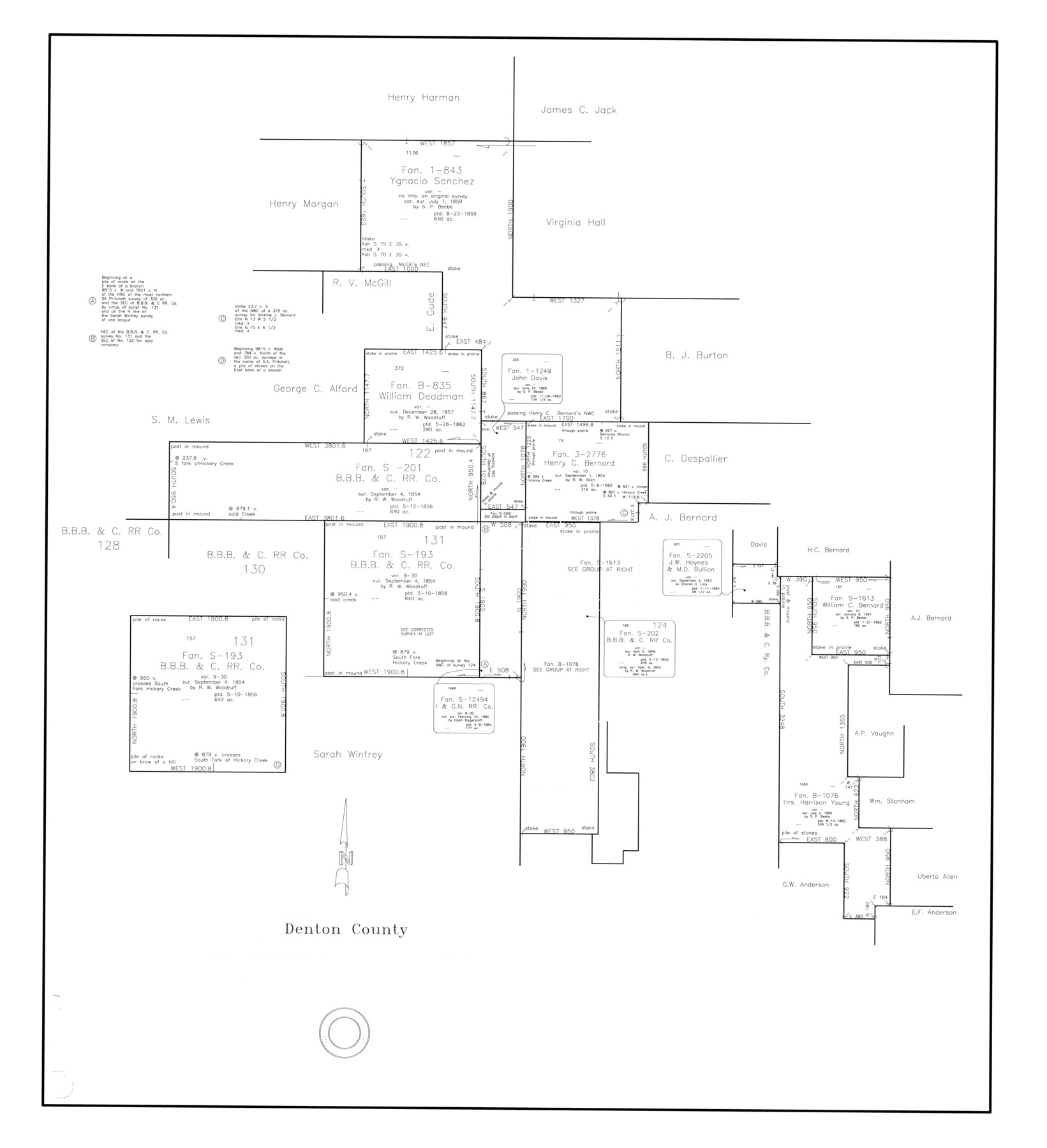
Denton County Working Sketch 32
-
Map/Doc
68637
-
Collection
General Map Collection
-
Counties
Denton
-
Subjects
Surveying Working Sketch
-
Height x Width
35.1 x 32.0 inches
89.2 x 81.3 cm
Part of: General Map Collection
McMullen County Sketch File 13

Print $4.00
- Digital $50.00
McMullen County Sketch File 13
1876
Size 10.0 x 8.0 inches
Map/Doc 31359
Brewster County Rolled Sketch 66

Print $20.00
- Digital $50.00
Brewster County Rolled Sketch 66
1946
Size 33.0 x 36.2 inches
Map/Doc 61785
Newton County Rolled Sketch 19

Print $20.00
- Digital $50.00
Newton County Rolled Sketch 19
1956
Size 42.1 x 33.5 inches
Map/Doc 6848
Hutchinson County Rolled Sketch 16

Print $20.00
- Digital $50.00
Hutchinson County Rolled Sketch 16
1912
Size 27.5 x 30.2 inches
Map/Doc 6284
Flight Mission No. DIX-7P, Frame 83, Aransas County

Print $20.00
- Digital $50.00
Flight Mission No. DIX-7P, Frame 83, Aransas County
1956
Size 18.8 x 22.5 inches
Map/Doc 83877
Clay County Boundary File 12

Print $8.00
- Digital $50.00
Clay County Boundary File 12
Size 14.3 x 8.8 inches
Map/Doc 51406
Haskell County Sketch File 26

Print $9.00
- Digital $50.00
Haskell County Sketch File 26
1992
Size 11.3 x 8.8 inches
Map/Doc 26182
Flight Mission No. DIX-8P, Frame 93, Aransas County

Print $20.00
- Digital $50.00
Flight Mission No. DIX-8P, Frame 93, Aransas County
1956
Size 18.5 x 22.3 inches
Map/Doc 83918
Flight Mission No. DQO-2K, Frame 99, Galveston County

Print $20.00
- Digital $50.00
Flight Mission No. DQO-2K, Frame 99, Galveston County
1952
Size 18.8 x 22.5 inches
Map/Doc 85026
Cass County Working Sketch 28

Print $20.00
- Digital $50.00
Cass County Working Sketch 28
1979
Size 16.0 x 16.8 inches
Map/Doc 67931
Sherman County Rolled Sketch 6

Print $20.00
- Digital $50.00
Sherman County Rolled Sketch 6
1919
Size 37.3 x 36.0 inches
Map/Doc 10731
Comal County Sketch File 1

Print $6.00
- Digital $50.00
Comal County Sketch File 1
1846
Size 16.4 x 10.5 inches
Map/Doc 18995
You may also like
Cameron County Rolled Sketch 11A

Print $20.00
- Digital $50.00
Cameron County Rolled Sketch 11A
1934
Size 30.0 x 37.0 inches
Map/Doc 11048
Terrell County Working Sketch 21

Print $20.00
- Digital $50.00
Terrell County Working Sketch 21
1935
Size 24.0 x 17.9 inches
Map/Doc 62171
[Blocks 34-36, Township 1N]
![92032, [Blocks 34-36, Township 1N], Twichell Survey Records](https://historictexasmaps.com/wmedia_w700/maps/92032-1.tif.jpg)
Print $20.00
- Digital $50.00
[Blocks 34-36, Township 1N]
Size 37.0 x 24.0 inches
Map/Doc 92032
Richardsons New Map of the State of Texas Including Part of Mexico Compiled from Government Surveys and other Authentic Documents

Print $20.00
Richardsons New Map of the State of Texas Including Part of Mexico Compiled from Government Surveys and other Authentic Documents
1860
Size 26.7 x 34.5 inches
Map/Doc 79735
Harris County Sketch File 72

Print $6.00
- Digital $50.00
Harris County Sketch File 72
1941
Size 14.2 x 11.8 inches
Map/Doc 25537
Angelina County Boundary File 2

Print $20.00
- Digital $50.00
Angelina County Boundary File 2
Size 10.2 x 28.2 inches
Map/Doc 49773
Walker County State Real Property Sketch 1

Print $20.00
- Digital $50.00
Walker County State Real Property Sketch 1
2003
Size 35.8 x 30.3 inches
Map/Doc 78585
Hardin County Sketch File 35

Print $24.00
- Digital $50.00
Hardin County Sketch File 35
Size 9.2 x 8.4 inches
Map/Doc 25175
Concho County Working Sketch 24

Print $20.00
- Digital $50.00
Concho County Working Sketch 24
1981
Size 35.0 x 44.2 inches
Map/Doc 68206
Fractional Township No. 9 South Range No. 11 East of the Indian Meridian, Indian Territory

Print $20.00
- Digital $50.00
Fractional Township No. 9 South Range No. 11 East of the Indian Meridian, Indian Territory
1898
Size 19.3 x 24.4 inches
Map/Doc 75220
Ownership Map SE 1/4 Lubbock County

Print $20.00
- Digital $50.00
Ownership Map SE 1/4 Lubbock County
Size 37.2 x 36.4 inches
Map/Doc 89895
[Sketch of Public School Land Blocks A56, A57, B1, B2, B10, T&P 46]
![91978, [Sketch of Public School Land Blocks A56, A57, B1, B2, B10, T&P 46], Twichell Survey Records](https://historictexasmaps.com/wmedia_w700/maps/91978-1.tif.jpg)
Print $20.00
- Digital $50.00
[Sketch of Public School Land Blocks A56, A57, B1, B2, B10, T&P 46]
Size 20.0 x 23.2 inches
Map/Doc 91978