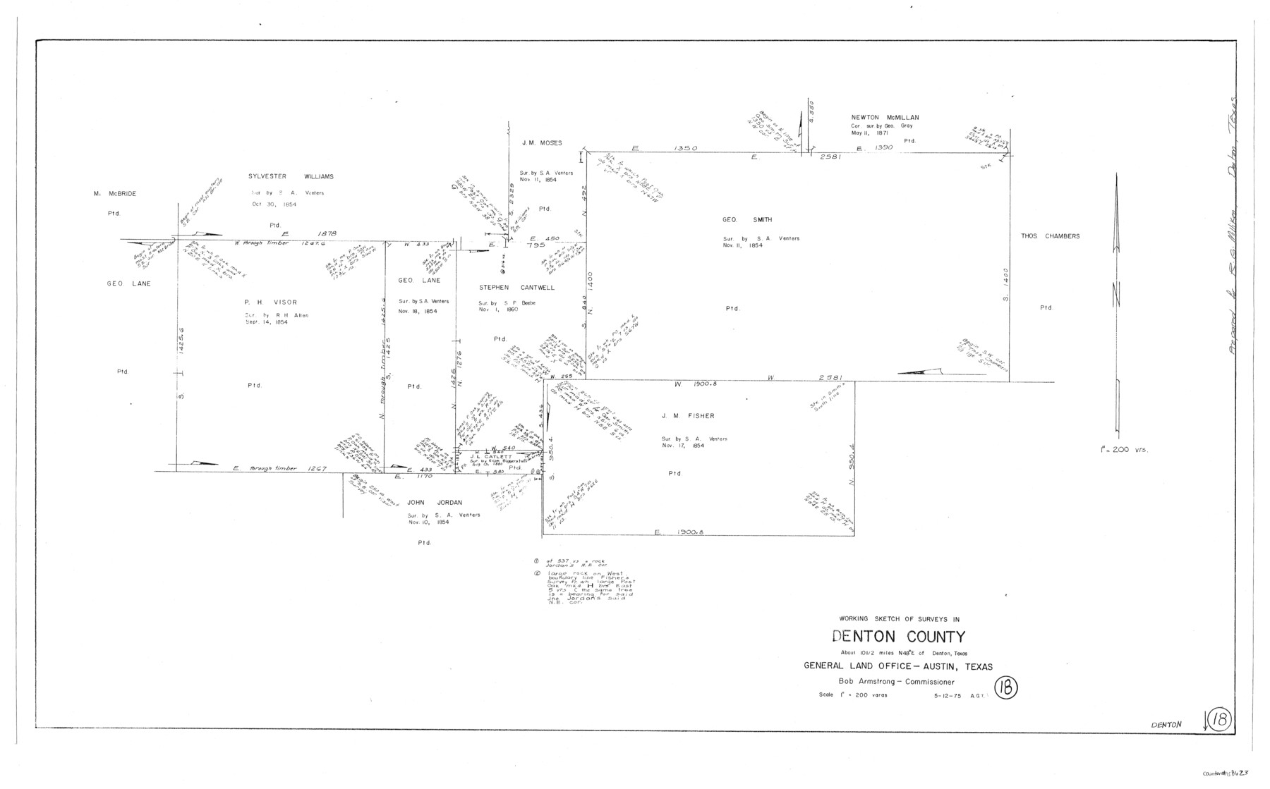
Denton County Working Sketch 18
-
Map/Doc
68623
-
Collection
General Map Collection
-
Object Dates
5/12/1975 (Creation Date)
-
People and Organizations
Abner G. Trigg (Draftsman)
-
Counties
Denton
-
Subjects
Surveying Working Sketch
-
Height x Width
24.1 x 38.8 inches
61.2 x 98.6 cm
-
Scale
1" = 200 varas
Part of: General Map Collection
Maps of Gulf Intracoastal Waterway, Texas - Sabine River to the Rio Grande and connecting waterways including ship channels

Print $20.00
- Digital $50.00
Maps of Gulf Intracoastal Waterway, Texas - Sabine River to the Rio Grande and connecting waterways including ship channels
1966
Size 14.6 x 22.2 inches
Map/Doc 61980
Flight Mission No. BRE-2P, Frame 81, Nueces County

Print $20.00
- Digital $50.00
Flight Mission No. BRE-2P, Frame 81, Nueces County
1956
Size 18.6 x 22.5 inches
Map/Doc 86776
Reeves County Working Sketch 6

Print $20.00
- Digital $50.00
Reeves County Working Sketch 6
1943
Size 14.1 x 18.4 inches
Map/Doc 63449
Presidio County Working Sketch 60

Print $20.00
- Digital $50.00
Presidio County Working Sketch 60
1957
Size 21.9 x 18.4 inches
Map/Doc 71737
Chambers County Sketch File 48

Print $88.00
- Digital $50.00
Chambers County Sketch File 48
1925
Size 14.3 x 8.8 inches
Map/Doc 18002
Flight Mission No. CGI-1N, Frame 167, Cameron County

Print $20.00
- Digital $50.00
Flight Mission No. CGI-1N, Frame 167, Cameron County
1955
Size 18.6 x 22.3 inches
Map/Doc 84502
Harris County Rolled Sketch 80B

Print $20.00
- Digital $50.00
Harris County Rolled Sketch 80B
Size 32.0 x 44.2 inches
Map/Doc 9137
Rio Grande Rectification Project, El Paso and Juarez Valley

Print $3.00
- Digital $50.00
Rio Grande Rectification Project, El Paso and Juarez Valley
1935
Size 9.7 x 14.9 inches
Map/Doc 1749
Fort Bend County Sketch File 8

Print $6.00
- Digital $50.00
Fort Bend County Sketch File 8
Size 6.3 x 4.2 inches
Map/Doc 22894
Culberson County Rolled Sketch 17

Print $20.00
- Digital $50.00
Culberson County Rolled Sketch 17
1904
Size 22.3 x 23.8 inches
Map/Doc 5649
Duval County Sketch File 34a

Print $20.00
- Digital $50.00
Duval County Sketch File 34a
1935
Size 45.7 x 34.2 inches
Map/Doc 10369
McMullen County Working Sketch 34

Print $20.00
- Digital $50.00
McMullen County Working Sketch 34
1959
Size 25.9 x 26.0 inches
Map/Doc 70735
You may also like
Hale County Working Sketch 5

Print $20.00
- Digital $50.00
Hale County Working Sketch 5
1980
Size 15.0 x 11.1 inches
Map/Doc 63325
Coryell County Boundary File 1b

Print $68.00
- Digital $50.00
Coryell County Boundary File 1b
Size 18.1 x 16.1 inches
Map/Doc 51894
Map of the United States and their Territories between the Mississippi and the Pacific Ocean and part of Mexico

Print $20.00
- Digital $50.00
Map of the United States and their Territories between the Mississippi and the Pacific Ocean and part of Mexico
Size 23.5 x 26.5 inches
Map/Doc 96526
Denton County Working Sketch 23

Print $20.00
- Digital $50.00
Denton County Working Sketch 23
1982
Size 18.6 x 14.1 inches
Map/Doc 68628
Presidio County Working Sketch 12

Print $20.00
- Digital $50.00
Presidio County Working Sketch 12
1941
Size 22.3 x 19.9 inches
Map/Doc 71687
Hutchinson County Rolled Sketch 40

Print $20.00
- Digital $50.00
Hutchinson County Rolled Sketch 40
1981
Size 26.8 x 37.6 inches
Map/Doc 6301
Panola County Working Sketch 37

Print $20.00
- Digital $50.00
Panola County Working Sketch 37
1984
Map/Doc 71446
Harris County Rolled Sketch R

Print $40.00
- Digital $50.00
Harris County Rolled Sketch R
1915
Size 20.3 x 93.8 inches
Map/Doc 9114
Outer Continental Shelf Leasing Maps (Louisiana Offshore Operations)

Print $20.00
- Digital $50.00
Outer Continental Shelf Leasing Maps (Louisiana Offshore Operations)
1955
Size 17.8 x 11.6 inches
Map/Doc 76083
Field notes for subdivisions of University Leagues/Surveys in Fannin, Grayson, McLennan, Hunt, Lamar, Collin, and Cooke Counties

Field notes for subdivisions of University Leagues/Surveys in Fannin, Grayson, McLennan, Hunt, Lamar, Collin, and Cooke Counties
Map/Doc 81727
Oldham County Sketch File 17

Print $10.00
- Digital $50.00
Oldham County Sketch File 17
1904
Size 7.7 x 6.4 inches
Map/Doc 33267
Flight Mission No. CLL-3N, Frame 15, Willacy County

Print $20.00
- Digital $50.00
Flight Mission No. CLL-3N, Frame 15, Willacy County
1950
Size 18.4 x 22.0 inches
Map/Doc 87081