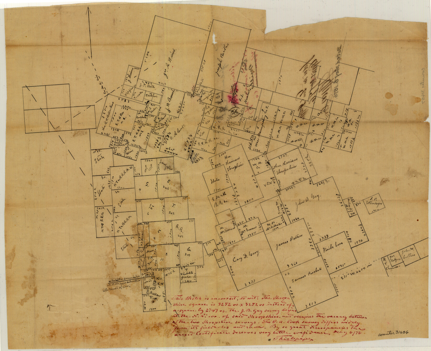
Mills County Sketch File 10 1/2
[Sketch of area in the northeast corner of the county]
-
Map/Doc
31656
-
Collection
General Map Collection
-
Object Dates
4/17/1876 (Creation Date)
4/20/1876 (File Date)
-
People and Organizations
S.C. Forester (Surveyor/Engineer)
-
Counties
Mills Hamilton
-
Subjects
Surveying Sketch File
-
Height x Width
14.4 x 17.6 inches
36.6 x 44.7 cm
-
Medium
paper, manuscript
-
Features
Brown's Creek
Bennett's Creek
Lampasas River
Part of: General Map Collection
Flight Mission No. CRK-8P, Frame 101, Refugio County

Print $20.00
- Digital $50.00
Flight Mission No. CRK-8P, Frame 101, Refugio County
1956
Size 18.7 x 22.3 inches
Map/Doc 86962
Presidio County Sketch File 6a

Print $2.00
- Digital $50.00
Presidio County Sketch File 6a
Size 7.9 x 6.6 inches
Map/Doc 34437
Connected Map of Austin's Colony

Print $20.00
- Digital $50.00
Connected Map of Austin's Colony
1892
Size 47.5 x 43.0 inches
Map/Doc 76074
Sabine County Working Sketch 11

Print $20.00
- Digital $50.00
Sabine County Working Sketch 11
1931
Size 30.9 x 34.0 inches
Map/Doc 63682
Flight Mission No. DCL-6C, Frame 46, Kenedy County

Print $20.00
- Digital $50.00
Flight Mission No. DCL-6C, Frame 46, Kenedy County
1943
Size 18.6 x 22.3 inches
Map/Doc 85888
Flight Mission No. DIX-8P, Frame 93, Aransas County

Print $20.00
- Digital $50.00
Flight Mission No. DIX-8P, Frame 93, Aransas County
1956
Size 18.5 x 22.3 inches
Map/Doc 83918
Flight Mission No. BRE-1P, Frame 151, Nueces County

Print $20.00
- Digital $50.00
Flight Mission No. BRE-1P, Frame 151, Nueces County
1956
Size 18.7 x 22.5 inches
Map/Doc 86711
Brewster County Rolled Sketch 101

Print $40.00
- Digital $50.00
Brewster County Rolled Sketch 101
1927
Size 74.2 x 42.3 inches
Map/Doc 9192
McMullen County Working Sketch 41

Print $20.00
- Digital $50.00
McMullen County Working Sketch 41
1978
Size 32.5 x 23.9 inches
Map/Doc 70742
Map of Bee County State of Texas

Print $20.00
- Digital $50.00
Map of Bee County State of Texas
1863
Size 31.1 x 25.3 inches
Map/Doc 3286
Topographical Map of the Rio Grande, Sheet No. 22

Print $20.00
- Digital $50.00
Topographical Map of the Rio Grande, Sheet No. 22
1912
Map/Doc 89546
Ward County Rolled Sketch 12A

Print $20.00
- Digital $50.00
Ward County Rolled Sketch 12A
Size 34.7 x 46.5 inches
Map/Doc 10108
You may also like
Midland County Rolled Sketch 2

Print $20.00
- Digital $50.00
Midland County Rolled Sketch 2
1949
Size 39.3 x 36.5 inches
Map/Doc 9513
Nueces County Rolled Sketch 38

Print $458.00
- Digital $50.00
Nueces County Rolled Sketch 38
Size 10.1 x 16.4 inches
Map/Doc 47717
Jones County Sketch File 11a

Print $40.00
- Digital $50.00
Jones County Sketch File 11a
Size 37.5 x 49.5 inches
Map/Doc 10510
El Paso County Working Sketch 54

Print $20.00
- Digital $50.00
El Paso County Working Sketch 54
1992
Size 31.5 x 29.0 inches
Map/Doc 69076
Clay County Sketch File 1

Print $22.00
- Digital $50.00
Clay County Sketch File 1
1855
Size 8.9 x 7.6 inches
Map/Doc 18386
Archer County Boundary File 4

Print $54.00
- Digital $50.00
Archer County Boundary File 4
Size 8.9 x 9.7 inches
Map/Doc 50103
Jackson County Working Sketch 11

Print $40.00
- Digital $50.00
Jackson County Working Sketch 11
1994
Size 33.8 x 48.4 inches
Map/Doc 66459
Edwards County Working Sketch 138

Print $20.00
- Digital $50.00
Edwards County Working Sketch 138
1999
Size 30.5 x 35.7 inches
Map/Doc 69015
Oldham County Sketch File 11

Print $26.00
- Digital $50.00
Oldham County Sketch File 11
Size 13.0 x 8.5 inches
Map/Doc 33247
Travis County Sketch File 72

Print $4.00
- Digital $50.00
Travis County Sketch File 72
1850
Size 12.7 x 8.4 inches
Map/Doc 38460
McMullen County Sketch File 20

Print $4.00
- Digital $50.00
McMullen County Sketch File 20
Size 8.1 x 10.0 inches
Map/Doc 31373
Map of Cherokee Co.

Print $40.00
- Digital $50.00
Map of Cherokee Co.
1902
Size 59.7 x 39.6 inches
Map/Doc 4747