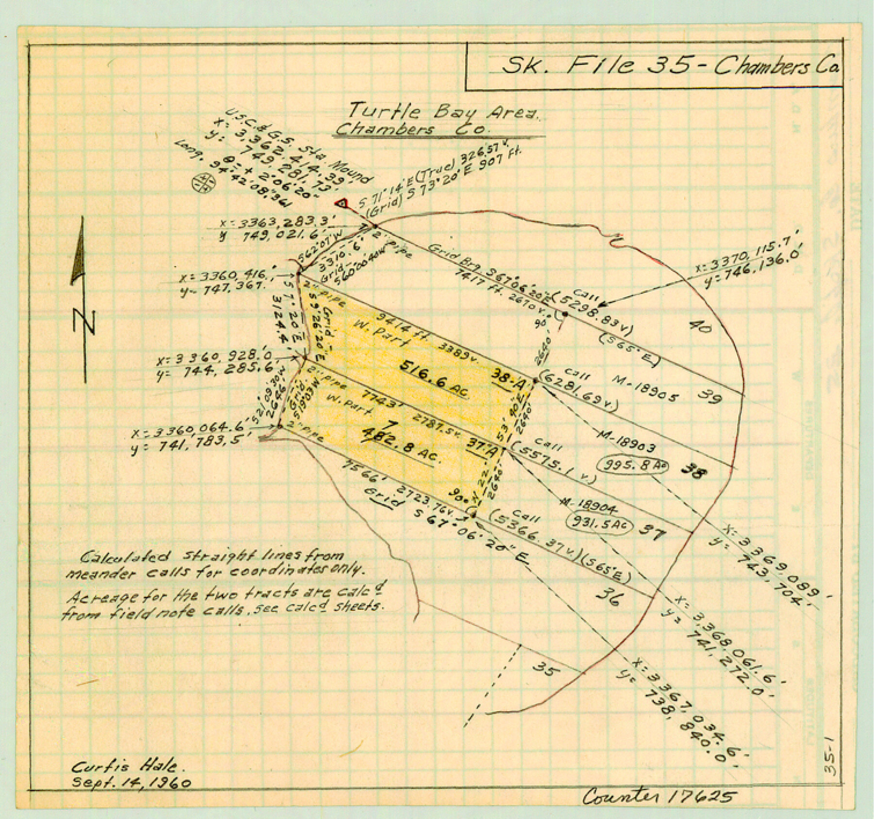
Chambers County Sketch File 35
[Field notes of the meanders of the Turtle Bay Shoreline and sketch of tracts within Turtle Bay]
-
Map/Doc
17625
-
Collection
General Map Collection
-
Object Dates
1952 (Survey Date)
1953/8/11 (File Date)
-
People and Organizations
W.O. Work (Surveyor/Engineer)
-
Counties
Chambers
-
Subjects
Surveying Sketch File
-
Height x Width
7.1 x 7.6 inches
18.0 x 19.3 cm
-
Medium
multi-page, multi-format
-
Features
Turtle Bay
Turtle Bay Pass
Part of: General Map Collection
Flight Mission No. BRE-1P, Frame 138, Nueces County

Print $20.00
- Digital $50.00
Flight Mission No. BRE-1P, Frame 138, Nueces County
1956
Size 18.4 x 22.3 inches
Map/Doc 86698
Jefferson County Sketch File 15a

Print $8.00
- Digital $50.00
Jefferson County Sketch File 15a
1872
Size 15.6 x 6.7 inches
Map/Doc 28156
Coast Chart No. 210 Aransas Pass and Corpus Christi Bay with the coast to latitude 27° 12' Texas

Print $20.00
- Digital $50.00
Coast Chart No. 210 Aransas Pass and Corpus Christi Bay with the coast to latitude 27° 12' Texas
1887
Size 26.7 x 18.3 inches
Map/Doc 72810
La Salle County Sketch File 44

Print $20.00
- Digital $50.00
La Salle County Sketch File 44
1937
Size 18.6 x 27.9 inches
Map/Doc 11989
Archer County Working Sketch 1a

Print $20.00
- Digital $50.00
Archer County Working Sketch 1a
Size 42.8 x 42.5 inches
Map/Doc 83096
Borden County Boundary File 7

Print $29.00
- Digital $50.00
Borden County Boundary File 7
1965
Size 11.2 x 8.8 inches
Map/Doc 61161
Navigation Maps of Gulf Intracoastal Waterway, Port Arthur to Brownsville, Texas

Print $4.00
- Digital $50.00
Navigation Maps of Gulf Intracoastal Waterway, Port Arthur to Brownsville, Texas
1951
Size 16.7 x 21.5 inches
Map/Doc 65441
Kimble County Rolled Sketch 19

Print $20.00
- Digital $50.00
Kimble County Rolled Sketch 19
Size 38.8 x 33.6 inches
Map/Doc 9339
Crockett County Rolled Sketch 69

Print $40.00
- Digital $50.00
Crockett County Rolled Sketch 69
1949
Size 39.4 x 54.8 inches
Map/Doc 8721
Carte du Lac de Mexico et de ses Environs Lors de la Conqueste des Espagnols

Print $20.00
- Digital $50.00
Carte du Lac de Mexico et de ses Environs Lors de la Conqueste des Espagnols
1753
Size 10.3 x 8.1 inches
Map/Doc 97080
Right-of-Way and Track Map, Texas State Railroad operated by the T. and N. O. R.R. Co.

Print $40.00
- Digital $50.00
Right-of-Way and Track Map, Texas State Railroad operated by the T. and N. O. R.R. Co.
1917
Size 24.3 x 55.7 inches
Map/Doc 64176
North America in the Age of Dinosaurs

North America in the Age of Dinosaurs
1993
Size 27.4 x 20.8 inches
Map/Doc 96831
You may also like
Irion County Rolled Sketch 17

Print $20.00
- Digital $50.00
Irion County Rolled Sketch 17
1956
Size 40.5 x 40.2 inches
Map/Doc 9255
Travis County Rolled Sketch 5

Print $20.00
- Digital $50.00
Travis County Rolled Sketch 5
1924
Size 24.1 x 27.9 inches
Map/Doc 8011
Bell County Sketch File 25

Print $8.00
- Digital $50.00
Bell County Sketch File 25
Size 5.1 x 5.3 inches
Map/Doc 14420
Hutchinson County Sketch File 35

Print $6.00
- Digital $50.00
Hutchinson County Sketch File 35
1935
Size 11.2 x 8.9 inches
Map/Doc 27267
Intracoastal Waterway, Houma, LA to Corpus Christi, TX

Print $5.00
- Digital $50.00
Intracoastal Waterway, Houma, LA to Corpus Christi, TX
Size 30.0 x 22.0 inches
Map/Doc 61911
Amended Plat New Hobbs Addition to New Hobbs, Lea County, New Mexico

Print $20.00
- Digital $50.00
Amended Plat New Hobbs Addition to New Hobbs, Lea County, New Mexico
Size 24.1 x 18.5 inches
Map/Doc 92418
Scurry County Rolled Sketch 2

Print $20.00
- Digital $50.00
Scurry County Rolled Sketch 2
Size 44.0 x 44.9 inches
Map/Doc 9911
Liberty County Sketch File 51

Print $4.00
- Digital $50.00
Liberty County Sketch File 51
Size 7.9 x 13.8 inches
Map/Doc 30017
Hale County Rolled Sketch 10

Print $40.00
- Digital $50.00
Hale County Rolled Sketch 10
Size 52.8 x 56.6 inches
Map/Doc 9096
Map of Africa engraved to illustrate Mitchell's new intermediate geography (Inset 1: Map of Egypt / Inset 2: Liberia and Sierra Leone)

Print $20.00
- Digital $50.00
Map of Africa engraved to illustrate Mitchell's new intermediate geography (Inset 1: Map of Egypt / Inset 2: Liberia and Sierra Leone)
1885
Size 9.0 x 12.2 inches
Map/Doc 93530
Lampasas County Working Sketch 8

Print $20.00
- Digital $50.00
Lampasas County Working Sketch 8
1958
Size 36.4 x 37.1 inches
Map/Doc 70285
