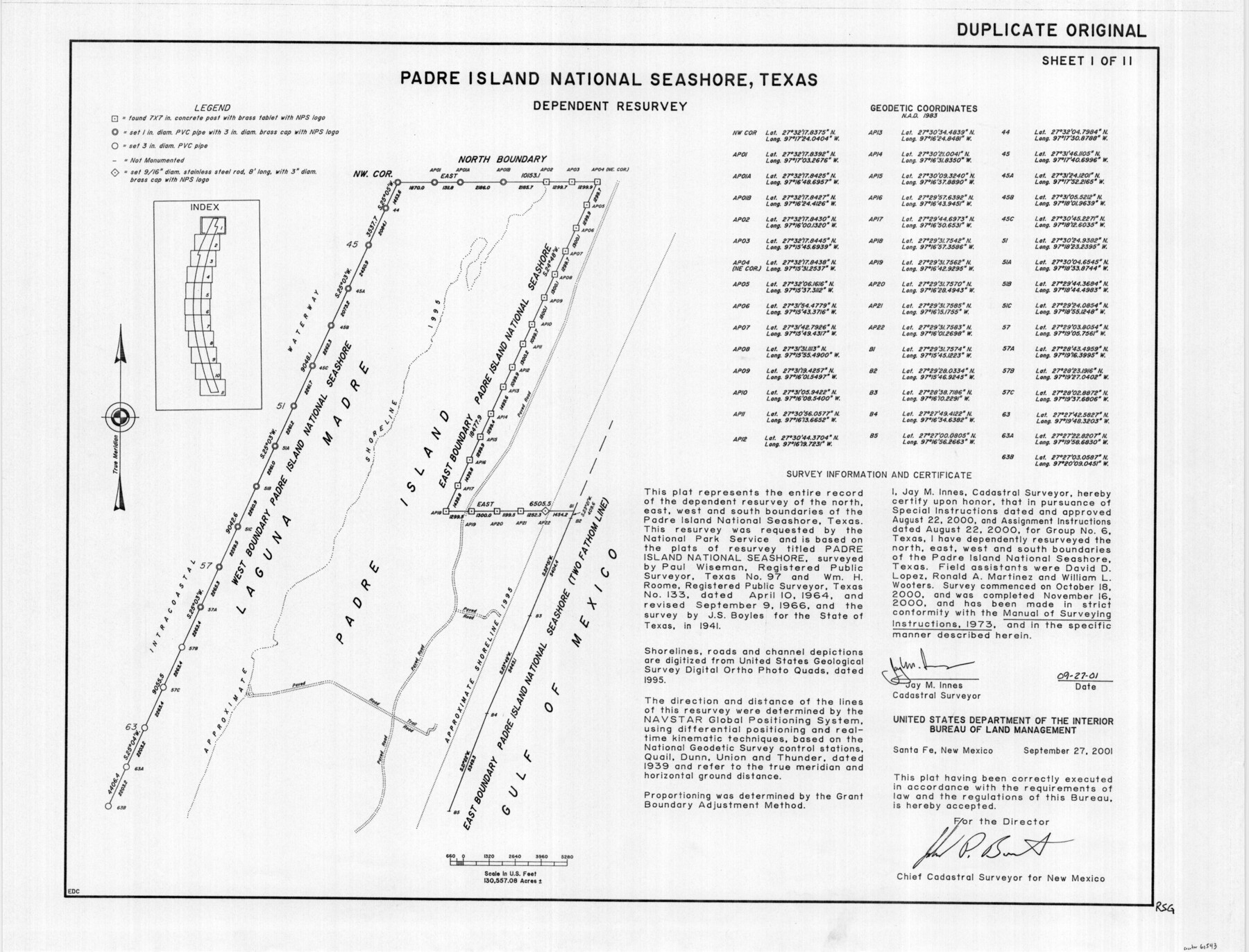
Padre Island National Seashore, Texas - Dependent Resurvey
-
Map/Doc
60543
-
Collection
General Map Collection
-
Object Dates
2001 (Creation Date)
-
Height x Width
18.4 x 24.2 inches
46.7 x 61.5 cm
Part of: General Map Collection
Brazoria County Sketch File 59

Print $364.00
- Digital $50.00
Brazoria County Sketch File 59
1996
Size 14.9 x 8.3 inches
Map/Doc 15398
Bowie County Sketch File 3

Print $40.00
- Digital $50.00
Bowie County Sketch File 3
Size 25.7 x 38.1 inches
Map/Doc 10941
Smith County Working Sketch 11

Print $20.00
- Digital $50.00
Smith County Working Sketch 11
1960
Size 18.6 x 21.6 inches
Map/Doc 63896
Kuechler's Corners, Texas & Pacific Ry. Co. 80 Mile Reserve

Print $703.00
- Digital $50.00
Kuechler's Corners, Texas & Pacific Ry. Co. 80 Mile Reserve
1934
Size 11.0 x 8.5 inches
Map/Doc 2248
[Anderson County]
![5051, [Anderson County], General Map Collection](https://historictexasmaps.com/wmedia_w700/maps/5051-GC.tif.jpg)
Print $20.00
- Digital $50.00
[Anderson County]
1848
Size 26.0 x 19.9 inches
Map/Doc 5051
Flight Mission No. DQN-2K, Frame 68, Calhoun County

Print $20.00
- Digital $50.00
Flight Mission No. DQN-2K, Frame 68, Calhoun County
1953
Size 18.6 x 22.2 inches
Map/Doc 84260
Atlas Geográfico, Estadístico é Histórico de la República Mexicana

Atlas Geográfico, Estadístico é Histórico de la República Mexicana
Map/Doc 95689
Reagan County Rolled Sketch 10

Print $20.00
- Digital $50.00
Reagan County Rolled Sketch 10
1939
Size 18.7 x 15.8 inches
Map/Doc 7438
Calhoun County

Print $20.00
- Digital $50.00
Calhoun County
1871
Size 22.4 x 18.3 inches
Map/Doc 888
Liberty County Working Sketch 14

Print $20.00
- Digital $50.00
Liberty County Working Sketch 14
1919
Size 17.0 x 25.4 inches
Map/Doc 70473
Map of McLennan County

Print $40.00
- Digital $50.00
Map of McLennan County
1896
Size 48.8 x 53.7 inches
Map/Doc 7952
Atascosa County Working Sketch 16

Print $20.00
- Digital $50.00
Atascosa County Working Sketch 16
1943
Size 16.3 x 20.2 inches
Map/Doc 67212
You may also like
Township 10 South Range 13 West, South Western District, Louisiana

Print $20.00
- Digital $50.00
Township 10 South Range 13 West, South Western District, Louisiana
1876
Size 19.5 x 24.6 inches
Map/Doc 65853
Hale County Working Sketch 2

Print $20.00
- Digital $50.00
Hale County Working Sketch 2
1916
Size 13.5 x 13.1 inches
Map/Doc 63322

Ector County Sketch File 13

Print $16.00
- Digital $50.00
Ector County Sketch File 13
1988
Size 11.5 x 9.0 inches
Map/Doc 21651
[Central Part of Hockley County]
![91192, [Central Part of Hockley County], Twichell Survey Records](https://historictexasmaps.com/wmedia_w700/maps/91192-1.tif.jpg)
Print $20.00
- Digital $50.00
[Central Part of Hockley County]
Size 34.6 x 21.0 inches
Map/Doc 91192

Brewster County Sketch File NS-11

Print $4.00
- Digital $50.00
Brewster County Sketch File NS-11
1948
Size 14.2 x 8.7 inches
Map/Doc 16218
Marion County Working Sketch 1

Print $20.00
- Digital $50.00
Marion County Working Sketch 1
Size 15.2 x 23.3 inches
Map/Doc 70776
de Leon Empresario Colony. April 30, 1829

Print $20.00
de Leon Empresario Colony. April 30, 1829
2020
Size 18.5 x 21.7 inches
Map/Doc 95990
Flight Mission No. DCL-7C, Frame 12, Kenedy County

Print $20.00
- Digital $50.00
Flight Mission No. DCL-7C, Frame 12, Kenedy County
1943
Size 15.4 x 15.3 inches
Map/Doc 86004
[Surveys in Austin's Colony]
![78, [Surveys in Austin's Colony], General Map Collection](https://historictexasmaps.com/wmedia_w700/maps/78.tif.jpg)
Print $20.00
- Digital $50.00
[Surveys in Austin's Colony]
Size 16.0 x 13.0 inches
Map/Doc 78
Harrison County Sketch File 11

Print $22.00
- Digital $50.00
Harrison County Sketch File 11
1904
Size 9.2 x 9.3 inches
Map/Doc 26052