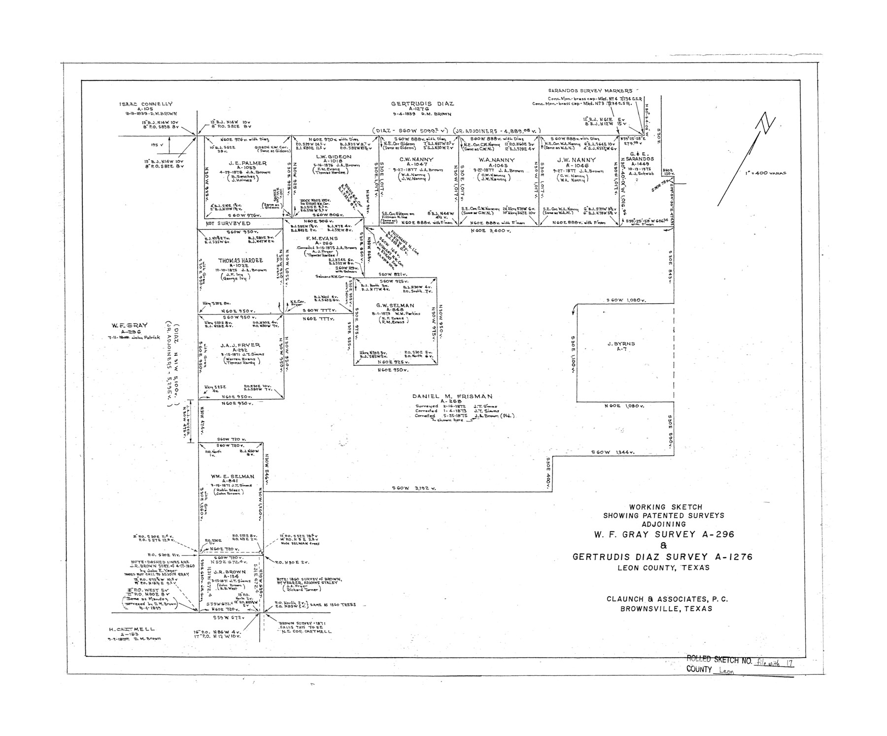
Leon County Rolled Sketch 17
Working sketch showing patented surveys adjoining W.F. Gray survey A-296 & Gertrudis Diaz survey A-1276, Leon County, Texas
-
Map/Doc
6603
-
Collection
General Map Collection
-
People and Organizations
M.L. Claunch (Surveyor/Engineer)
-
Counties
Leon
-
Subjects
Surveying Rolled Sketch
-
Height x Width
20.5 x 24.7 inches
52.1 x 62.7 cm
-
Medium
mylar, print
-
Scale
1" = 400 varas
Part of: General Map Collection
El Paso County Rolled Sketch 52

Print $20.00
- Digital $50.00
El Paso County Rolled Sketch 52
1929
Size 18.4 x 24.4 inches
Map/Doc 5842
Hockley County Sketch File 11

Print $8.00
- Digital $50.00
Hockley County Sketch File 11
Size 14.3 x 9.0 inches
Map/Doc 26544
Upshur County Rolled Sketch 2

Print $20.00
- Digital $50.00
Upshur County Rolled Sketch 2
1954
Size 26.8 x 23.4 inches
Map/Doc 8061
Terry County Boundary File 4a

Print $70.00
- Digital $50.00
Terry County Boundary File 4a
Size 11.4 x 8.8 inches
Map/Doc 59249
[Liberty County, Texas]
![2058, [Liberty County, Texas], General Map Collection](https://historictexasmaps.com/wmedia_w700/maps/2058-1.tif.jpg)
Print $20.00
- Digital $50.00
[Liberty County, Texas]
1890
Size 23.7 x 18.3 inches
Map/Doc 2058
Map of the River Sabine from its mouth on the Gulf of Mexico in the sea to Logan's Ferry in latitude 31° 58' 24" north

Print $20.00
- Digital $50.00
Map of the River Sabine from its mouth on the Gulf of Mexico in the sea to Logan's Ferry in latitude 31° 58' 24" north
1842
Size 18.5 x 9.0 inches
Map/Doc 65384
Fort Bend County Working Sketch 10

Print $20.00
- Digital $50.00
Fort Bend County Working Sketch 10
1934
Size 30.6 x 20.2 inches
Map/Doc 69216
Crockett County Working Sketch 31

Print $20.00
- Digital $50.00
Crockett County Working Sketch 31
1924
Size 37.2 x 33.5 inches
Map/Doc 68364
Polk County Sketch File 34

Print $20.00
- Digital $50.00
Polk County Sketch File 34
Size 16.9 x 18.2 inches
Map/Doc 12194
Flight Mission No. DIX-10P, Frame 151, Aransas County

Print $20.00
- Digital $50.00
Flight Mission No. DIX-10P, Frame 151, Aransas County
1956
Size 18.7 x 22.3 inches
Map/Doc 83953
Texas City Channel, Texas, Channel and Turning Basin Dredging - Sheet 5

Print $20.00
- Digital $50.00
Texas City Channel, Texas, Channel and Turning Basin Dredging - Sheet 5
1958
Size 28.2 x 40.9 inches
Map/Doc 61835
Matagorda County Sketch File 33

Print $6.00
- Digital $50.00
Matagorda County Sketch File 33
1938
Size 14.2 x 8.8 inches
Map/Doc 30817
You may also like
Terry County Boundary File 3

Print $78.00
- Digital $50.00
Terry County Boundary File 3
Size 7.4 x 8.8 inches
Map/Doc 59216
[T. & P. Block 33, Township 4N]
![90558, [T. & P. Block 33, Township 4N], Twichell Survey Records](https://historictexasmaps.com/wmedia_w700/maps/90558-1.tif.jpg)
Print $3.00
- Digital $50.00
[T. & P. Block 33, Township 4N]
Size 9.4 x 14.2 inches
Map/Doc 90558
Wilbarger County Sketch File 11

Print $4.00
- Digital $50.00
Wilbarger County Sketch File 11
1885
Size 14.2 x 8.6 inches
Map/Doc 40183
Hopkins County

Print $20.00
- Digital $50.00
Hopkins County
1942
Size 43.6 x 41.6 inches
Map/Doc 1858
Culberson County Sketch File 18

Print $8.00
- Digital $50.00
Culberson County Sketch File 18
Size 14.3 x 8.8 inches
Map/Doc 20185
Coryell County Sketch File 11

Print $4.00
- Digital $50.00
Coryell County Sketch File 11
Size 8.7 x 11.7 inches
Map/Doc 19364
Map illustrating the general geological features of the country west of the Mississippi River compiled from the surveys of W.H. Emory and from the Pacific Railroad surveys & other sources

Print $20.00
- Digital $50.00
Map illustrating the general geological features of the country west of the Mississippi River compiled from the surveys of W.H. Emory and from the Pacific Railroad surveys & other sources
1857
Size 21.2 x 24.7 inches
Map/Doc 95172
Motley County Sketch File 10 (N)

Print $20.00
- Digital $50.00
Motley County Sketch File 10 (N)
1900
Size 14.0 x 8.5 inches
Map/Doc 32026
Gulf, Beaumont & Kansas City Railway

Print $40.00
- Digital $50.00
Gulf, Beaumont & Kansas City Railway
1909
Size 25.1 x 92.5 inches
Map/Doc 64435
[Copied from a chart of Galveston Bar and Harbor]
![72760, [Copied from a chart of Galveston Bar and Harbor], General Map Collection](https://historictexasmaps.com/wmedia_w700/maps/72760.tif.jpg)
Print $20.00
- Digital $50.00
[Copied from a chart of Galveston Bar and Harbor]
1846
Size 18.3 x 25.3 inches
Map/Doc 72760
The Judicial District/County of Smith. Abolished, Spring 1842

Print $20.00
The Judicial District/County of Smith. Abolished, Spring 1842
2020
Size 19.6 x 21.7 inches
Map/Doc 96347
Map of Orange County

Print $20.00
- Digital $50.00
Map of Orange County
1880
Size 15.2 x 19.2 inches
Map/Doc 3930