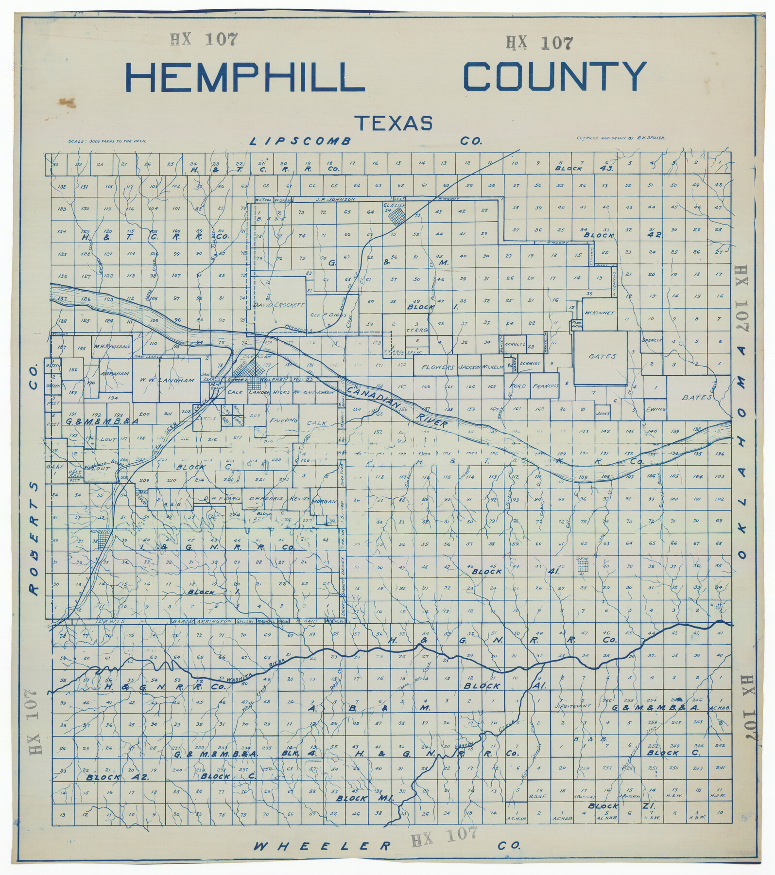
Hemphill County Texas
HX107
-
Map/Doc
92183
-
Collection
Twichell Survey Records
-
People and Organizations
R.H. Spiller (Compiler)
-
Counties
Hemphill
-
Subjects
County
-
Height x Width
21.9 x 24.6 inches
55.6 x 62.5 cm
Part of: Twichell Survey Records
[Nathaniel H. Cochran Survey and Vicinity]
![91494, [Nathaniel H. Cochran Survey and Vicinity], Twichell Survey Records](https://historictexasmaps.com/wmedia_w700/maps/91494-1.tif.jpg)
Print $20.00
- Digital $50.00
[Nathaniel H. Cochran Survey and Vicinity]
Size 26.7 x 18.8 inches
Map/Doc 91494
[Map showing Jno. H. Gibson Block D]
![92001, [Map showing Jno. H. Gibson Block D], Twichell Survey Records](https://historictexasmaps.com/wmedia_w700/maps/92001-1.tif.jpg)
Print $20.00
- Digital $50.00
[Map showing Jno. H. Gibson Block D]
Size 17.9 x 15.0 inches
Map/Doc 92001

[Morris County School Land Leagues and vicinity]
![90336, [Morris County School Land Leagues and vicinity], Twichell Survey Records](https://historictexasmaps.com/wmedia_w700/maps/90336-1.tif.jpg)
Print $20.00
- Digital $50.00
[Morris County School Land Leagues and vicinity]
Size 14.3 x 12.7 inches
Map/Doc 90336
[Part of North line of County, North of Block G]
![90806, [Part of North line of County, North of Block G], Twichell Survey Records](https://historictexasmaps.com/wmedia_w700/maps/90806-1.tif.jpg)
Print $20.00
- Digital $50.00
[Part of North line of County, North of Block G]
Size 17.9 x 12.5 inches
Map/Doc 90806
Sketch in Lynn, Terry, Gaines & Dawson Counties, Texas

Print $40.00
- Digital $50.00
Sketch in Lynn, Terry, Gaines & Dawson Counties, Texas
1940
Size 52.5 x 32.6 inches
Map/Doc 89685
[East Line of Moore County]
![91418, [East Line of Moore County], Twichell Survey Records](https://historictexasmaps.com/wmedia_w700/maps/91418-1.tif.jpg)
Print $20.00
- Digital $50.00
[East Line of Moore County]
Size 16.1 x 18.4 inches
Map/Doc 91418
Sketch Showing Boundary Between Randall and Deaf Smith Counties

Print $20.00
- Digital $50.00
Sketch Showing Boundary Between Randall and Deaf Smith Counties
Size 13.4 x 33.3 inches
Map/Doc 91832
North Line of Stonewall County, South Line of King County

Print $20.00
- Digital $50.00
North Line of Stonewall County, South Line of King County
1895
Size 8.0 x 41.1 inches
Map/Doc 91058
![90513, [Capitol Lands], Twichell Survey Records](https://historictexasmaps.com/wmedia_w700/maps/90513-1.tif.jpg)
Working Sketch in Dallam County [shows H. & T. C. Ry. Co. Block 47 1/2]
![90649, Working Sketch in Dallam County [shows H. & T. C. Ry. Co. Block 47 1/2], Twichell Survey Records](https://historictexasmaps.com/wmedia_w700/maps/90649-1.tif.jpg)
Print $20.00
- Digital $50.00
Working Sketch in Dallam County [shows H. & T. C. Ry. Co. Block 47 1/2]
1906
Size 18.5 x 18.2 inches
Map/Doc 90649
[Sketch of Block A1 in Hartley County]
![90762, [Sketch of Block A1 in Hartley County], Twichell Survey Records](https://historictexasmaps.com/wmedia_w700/maps/90762-1.tif.jpg)
Print $20.00
- Digital $50.00
[Sketch of Block A1 in Hartley County]
1902
Size 11.3 x 21.4 inches
Map/Doc 90762
You may also like
Travis County Working Sketch 17

Print $20.00
- Digital $50.00
Travis County Working Sketch 17
1944
Size 27.8 x 23.3 inches
Map/Doc 69401
Map of City of Fort Worth, Texas

Print $20.00
- Digital $50.00
Map of City of Fort Worth, Texas
1934
Size 32.9 x 39.2 inches
Map/Doc 4839
Hutchinson County Rolled Sketch 2

Print $20.00
- Digital $50.00
Hutchinson County Rolled Sketch 2
Size 36.1 x 42.0 inches
Map/Doc 76069
Val Verde County Sketch File 56

Print $2.00
- Digital $50.00
Val Verde County Sketch File 56
2006
Size 8.5 x 11.0 inches
Map/Doc 89016
Glasscock County Rolled Sketch 5

Print $20.00
- Digital $50.00
Glasscock County Rolled Sketch 5
1944
Size 41.4 x 33.7 inches
Map/Doc 6016
[Index map of T. & P. Ry. Company’s 80-mile Trans-Pecos Reserve’s perpetuated corners - South Part]
![69766, [Index map of T. & P. Ry. Company’s 80-mile Trans-Pecos Reserve’s perpetuated corners - South Part], General Map Collection](https://historictexasmaps.com/wmedia_w700/maps/69766.tif.jpg)
Print $40.00
- Digital $50.00
[Index map of T. & P. Ry. Company’s 80-mile Trans-Pecos Reserve’s perpetuated corners - South Part]
Size 23.1 x 90.1 inches
Map/Doc 69766
Howard County Rolled Sketch 6

Print $20.00
- Digital $50.00
Howard County Rolled Sketch 6
Size 17.3 x 18.1 inches
Map/Doc 6235
Guadalupe County Sketch File 4

Print $4.00
- Digital $50.00
Guadalupe County Sketch File 4
1869
Size 8.2 x 7.9 inches
Map/Doc 24654
Bee County Working Sketch 12

Print $20.00
- Digital $50.00
Bee County Working Sketch 12
1943
Size 25.4 x 19.9 inches
Map/Doc 67262
Marion County Working Sketch 36

Print $20.00
- Digital $50.00
Marion County Working Sketch 36
1987
Size 23.5 x 28.9 inches
Map/Doc 70812
Comanche County

Print $20.00
- Digital $50.00
Comanche County
1896
Size 41.7 x 44.8 inches
Map/Doc 4736
La Salle County Rolled Sketch 12

Print $20.00
- Digital $50.00
La Salle County Rolled Sketch 12
Size 25.3 x 37.2 inches
Map/Doc 6575