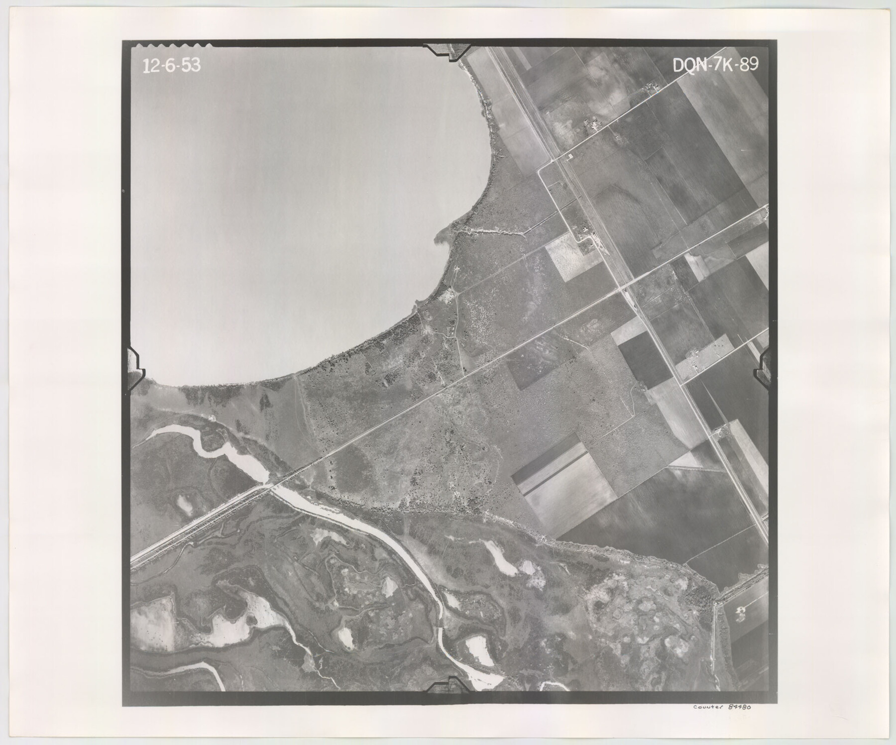
Flight Mission No. DQN-7K, Frame 89, Calhoun County
DQN-7K-89
-
Map/Doc
84480
-
Collection
General Map Collection
-
Object Dates
1953/12/6 (Creation Date)
-
People and Organizations
U. S. Department of Agriculture (Publisher)
-
Counties
Calhoun
-
Subjects
Aerial Photograph
-
Height x Width
18.4 x 22.2 inches
46.7 x 56.4 cm
-
Comments
Flown by Aero Exploration Company of Tulsa, Oklahoma.
Part of: General Map Collection
Flight Mission No. CGI-4N, Frame 177, Cameron County

Print $20.00
- Digital $50.00
Flight Mission No. CGI-4N, Frame 177, Cameron County
1955
Size 18.5 x 22.2 inches
Map/Doc 84680
Upton County Working Sketch 5

Print $20.00
- Digital $50.00
Upton County Working Sketch 5
1909
Size 15.9 x 27.1 inches
Map/Doc 69501
Galveston County Sketch File 18

Print $4.00
- Digital $50.00
Galveston County Sketch File 18
Size 5.5 x 8.0 inches
Map/Doc 23388
Montgomery County Sketch File 14

Print $42.00
- Digital $50.00
Montgomery County Sketch File 14
1905
Size 11.0 x 8.8 inches
Map/Doc 31805
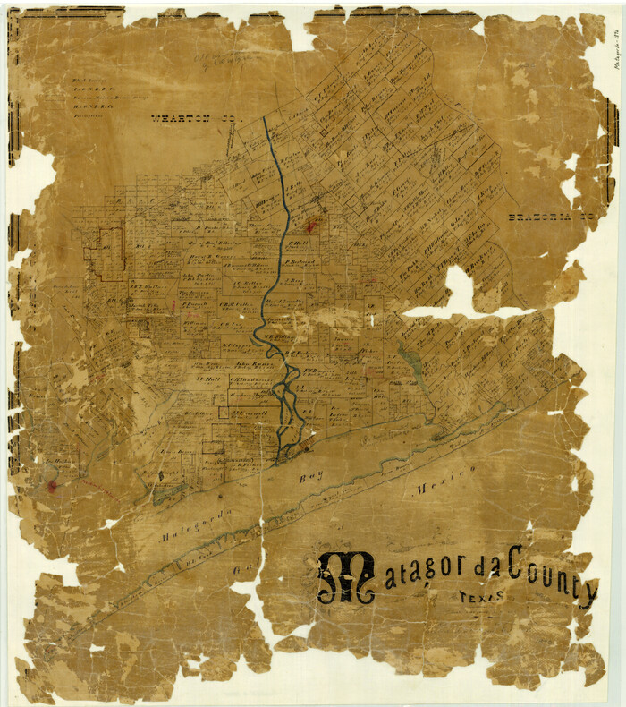
Matagorda County Texas
Print $20.00
- Digital $50.00
Matagorda County Texas
1896
Size 30.8 x 27.3 inches
Map/Doc 3845
Sterling County Rolled Sketch 13

Print $20.00
- Digital $50.00
Sterling County Rolled Sketch 13
1945
Size 34.9 x 27.3 inches
Map/Doc 7847
Hutchinson Co.

Print $20.00
- Digital $50.00
Hutchinson Co.
1891
Size 27.5 x 21.3 inches
Map/Doc 4986
Flight Mission No. CRK-7P, Frame 133, Refugio County

Print $20.00
- Digital $50.00
Flight Mission No. CRK-7P, Frame 133, Refugio County
1956
Size 18.3 x 22.1 inches
Map/Doc 86956
Pecos County Working Sketch 97

Print $40.00
- Digital $50.00
Pecos County Working Sketch 97
1970
Size 35.7 x 48.9 inches
Map/Doc 71570
Garza County Sketch File 8

Print $8.00
- Digital $50.00
Garza County Sketch File 8
1900
Size 10.3 x 8.2 inches
Map/Doc 24062
Edwards County Sketch File 47

Print $24.00
- Digital $50.00
Edwards County Sketch File 47
1955
Size 11.4 x 8.9 inches
Map/Doc 21795
Garza County Working Sketch 6

Print $20.00
- Digital $50.00
Garza County Working Sketch 6
1944
Size 24.8 x 20.2 inches
Map/Doc 63153
You may also like
Zapata County Rolled Sketch 26

Print $20.00
- Digital $50.00
Zapata County Rolled Sketch 26
1982
Size 43.0 x 30.7 inches
Map/Doc 8319
Motley County Sketch File 12 (N)

Print $3.00
- Digital $50.00
Motley County Sketch File 12 (N)
Size 20.0 x 18.4 inches
Map/Doc 42141
Fisher County Working Sketch 3

Print $20.00
- Digital $50.00
Fisher County Working Sketch 3
1926
Size 19.7 x 15.7 inches
Map/Doc 69137
Duval County Sketch File 36b

Print $60.00
- Digital $50.00
Duval County Sketch File 36b
1935
Size 28.4 x 23.3 inches
Map/Doc 11393
General Highway Map, Cherokee County, Texas

Print $20.00
General Highway Map, Cherokee County, Texas
1939
Size 25.2 x 18.5 inches
Map/Doc 79045
The United States and the Relative Position of the Oregon and Texas

Print $20.00
- Digital $50.00
The United States and the Relative Position of the Oregon and Texas
1850
Size 16.8 x 23.1 inches
Map/Doc 93666
Dawson County Working Sketch 20

Print $20.00
- Digital $50.00
Dawson County Working Sketch 20
1963
Size 18.2 x 23.0 inches
Map/Doc 68564
Starr County Boundary File 99

Print $56.00
- Digital $50.00
Starr County Boundary File 99
Size 9.2 x 6.2 inches
Map/Doc 58846

Corpus Christi Bay

Print $20.00
- Digital $50.00
Corpus Christi Bay
1976
Size 36.2 x 47.8 inches
Map/Doc 73476
Harris County Working Sketch 88

Print $20.00
- Digital $50.00
Harris County Working Sketch 88
1972
Size 30.3 x 38.4 inches
Map/Doc 65980
Newton County Boundary File 1a

Print $20.00
- Digital $50.00
Newton County Boundary File 1a
Size 36.7 x 17.8 inches
Map/Doc 57616