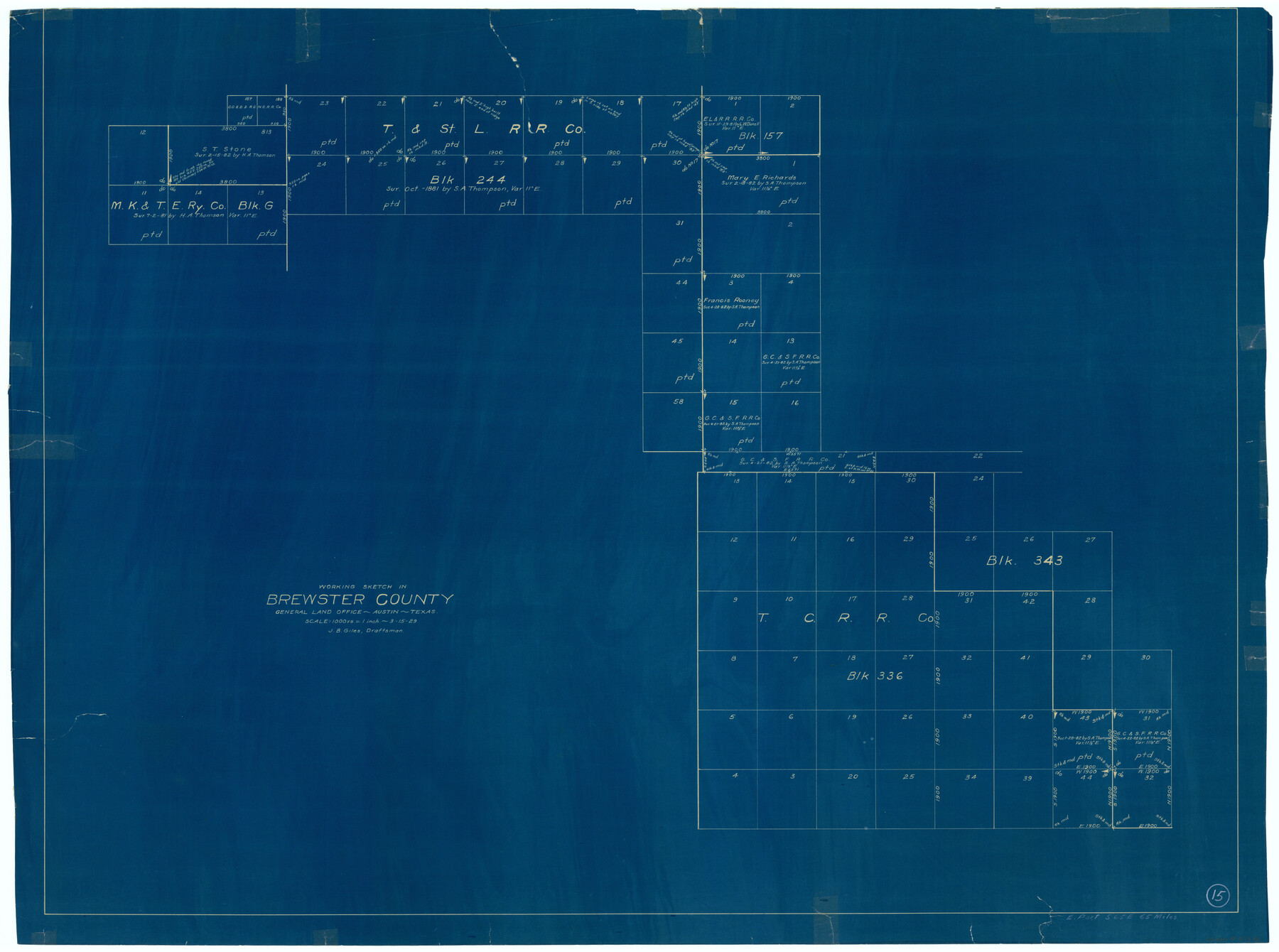
Brewster County Working Sketch 15
-
Map/Doc
67548
-
Collection
General Map Collection
-
Object Dates
3/15/1929 (Creation Date)
-
People and Organizations
J.B. Giles (Draftsman)
-
Counties
Brewster
-
Subjects
Surveying Working Sketch
-
Height x Width
30.4 x 40.9 inches
77.2 x 103.9 cm
-
Scale
1" = 1000 varas
Part of: General Map Collection
Right of Way & Track Map San Antonio & Aransas Pass Railway Co.

Print $40.00
- Digital $50.00
Right of Way & Track Map San Antonio & Aransas Pass Railway Co.
1919
Size 25.6 x 57.0 inches
Map/Doc 64025
Val Verde County Rolled Sketch 70

Print $20.00
- Digital $50.00
Val Verde County Rolled Sketch 70
1958
Size 23.2 x 18.8 inches
Map/Doc 8132
Stephens County Sketch File 14

Print $6.00
- Digital $50.00
Stephens County Sketch File 14
Size 8.2 x 5.9 inches
Map/Doc 37065
Franklin County Sketch File 2a

Print $6.00
- Digital $50.00
Franklin County Sketch File 2a
1857
Size 8.6 x 10.5 inches
Map/Doc 23012
Motley County Sketch File F (S)

Print $14.00
- Digital $50.00
Motley County Sketch File F (S)
1904
Size 9.1 x 5.9 inches
Map/Doc 32179
Aransas County Sketch File 21c

Print $4.00
- Digital $50.00
Aransas County Sketch File 21c
Size 8.7 x 14.0 inches
Map/Doc 13162
Presidio County Working Sketch 112

Print $20.00
- Digital $50.00
Presidio County Working Sketch 112
1979
Size 41.7 x 35.6 inches
Map/Doc 71789
Wharton County Sketch File 3

Print $4.00
- Digital $50.00
Wharton County Sketch File 3
1875
Size 9.1 x 8.3 inches
Map/Doc 39915
Map of Lavaca County

Print $20.00
- Digital $50.00
Map of Lavaca County
1866
Size 22.3 x 23.7 inches
Map/Doc 3802
Dallas County Sketch File 15

Print $10.00
- Digital $50.00
Dallas County Sketch File 15
1863
Size 11.5 x 8.5 inches
Map/Doc 20430
Baylor County Working Sketch 9

Print $20.00
- Digital $50.00
Baylor County Working Sketch 9
1956
Size 24.7 x 27.4 inches
Map/Doc 67294
San Saba County Sketch File 4a

Print $4.00
- Digital $50.00
San Saba County Sketch File 4a
1854
Size 9.6 x 8.5 inches
Map/Doc 36410
You may also like
Live Oak County Working Sketch 16

Print $20.00
- Digital $50.00
Live Oak County Working Sketch 16
1954
Size 22.2 x 21.8 inches
Map/Doc 70601
General Highway Map. Detail of Cities and Towns in Orange County, Texas [Orange and vicinity]
![79622, General Highway Map. Detail of Cities and Towns in Orange County, Texas [Orange and vicinity], Texas State Library and Archives](https://historictexasmaps.com/wmedia_w700/maps/79622.tif.jpg)
Print $20.00
General Highway Map. Detail of Cities and Towns in Orange County, Texas [Orange and vicinity]
1961
Size 18.1 x 24.4 inches
Map/Doc 79622
General Highway Map. Detail of Cities and Towns in Dallas County, Texas [Dallas and vicinity]
![79431, General Highway Map. Detail of Cities and Towns in Dallas County, Texas [Dallas and vicinity], Texas State Library and Archives](https://historictexasmaps.com/wmedia_w700/maps/79431.tif.jpg)
Print $20.00
General Highway Map. Detail of Cities and Towns in Dallas County, Texas [Dallas and vicinity]
1961
Size 18.1 x 24.4 inches
Map/Doc 79431
Johnson County Working Sketch 32

Print $20.00
- Digital $50.00
Johnson County Working Sketch 32
2008
Size 29.2 x 27.4 inches
Map/Doc 88817
General Highway Map, Nueces County, Texas

Print $20.00
General Highway Map, Nueces County, Texas
1961
Size 24.6 x 18.2 inches
Map/Doc 79616
Flight Mission No. BRA-16M, Frame 106, Jefferson County

Print $20.00
- Digital $50.00
Flight Mission No. BRA-16M, Frame 106, Jefferson County
1953
Size 18.6 x 22.3 inches
Map/Doc 85718
Donley County Sketch File 2

Print $20.00
- Digital $50.00
Donley County Sketch File 2
Size 20.3 x 18.4 inches
Map/Doc 11363
Jones County Sketch File 14

Print $4.00
- Digital $50.00
Jones County Sketch File 14
1882
Size 11.7 x 8.8 inches
Map/Doc 28501
General Highway Map, Ward County, Texas

Print $20.00
General Highway Map, Ward County, Texas
1940
Size 18.5 x 25.1 inches
Map/Doc 79271
Flight Mission No. DAG-17K, Frame 121, Matagorda County

Print $20.00
- Digital $50.00
Flight Mission No. DAG-17K, Frame 121, Matagorda County
1952
Size 16.4 x 16.5 inches
Map/Doc 86341
Live Oak County Rolled Sketch 6

Print $20.00
- Digital $50.00
Live Oak County Rolled Sketch 6
1947
Size 43.6 x 25.9 inches
Map/Doc 6634
El Paso County Working Sketch 26

Print $20.00
- Digital $50.00
El Paso County Working Sketch 26
1963
Size 35.4 x 18.6 inches
Map/Doc 69048