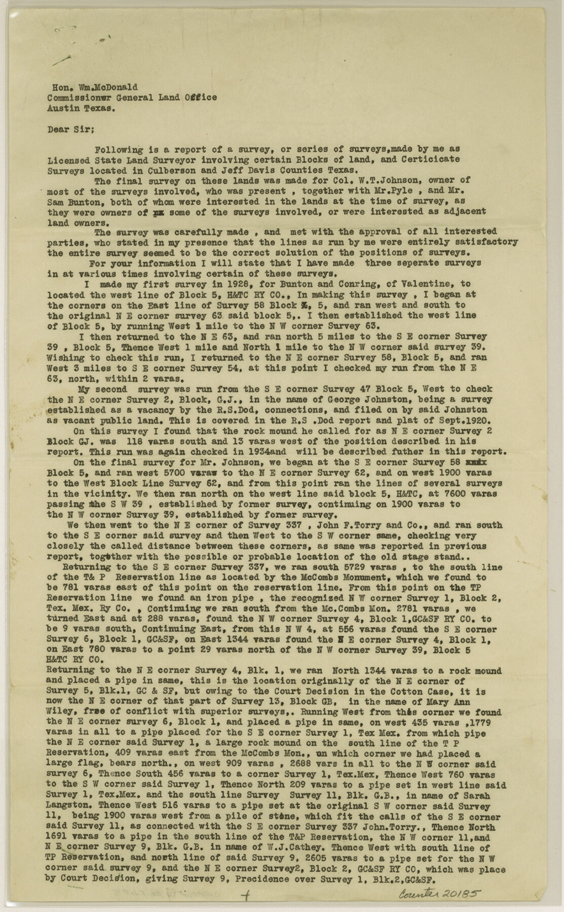
Culberson County Sketch File 18
[Statement of Jas. P. Dod of survey made for Col W. T. Johnson]
-
Map/Doc
20185
-
Collection
General Map Collection
-
Object Dates
1937/12/28 (File Date)
1928 (Survey Date)
-
People and Organizations
James P. Dod (Surveyor/Engineer)
R.S. Dod (Surveyor/Engineer)
-
Counties
Culberson Jeff Davis
-
Subjects
Surveying Sketch File
-
Height x Width
14.3 x 8.8 inches
36.3 x 22.4 cm
-
Medium
paper, print
-
Features
Chispa Station
Part of: General Map Collection
Morris County Rolled Sketch 2A

Print $20.00
- Digital $50.00
Morris County Rolled Sketch 2A
Size 36.2 x 19.3 inches
Map/Doc 10282
Foard County Sketch File 13

Print $6.00
- Digital $50.00
Foard County Sketch File 13
1885
Size 13.0 x 8.5 inches
Map/Doc 22816
Flight Mission No. DAG-21K, Frame 82, Matagorda County

Print $20.00
- Digital $50.00
Flight Mission No. DAG-21K, Frame 82, Matagorda County
1952
Size 18.5 x 22.3 inches
Map/Doc 86411
Old Miscellaneous File 6

Print $4.00
- Digital $50.00
Old Miscellaneous File 6
1847
Size 4.2 x 7.6 inches
Map/Doc 75420
Map of Stephens County

Print $20.00
- Digital $50.00
Map of Stephens County
1897
Size 43.2 x 37.6 inches
Map/Doc 16818
New Map of Texas with the Contiguous American and Mexican States

Print $20.00
- Digital $50.00
New Map of Texas with the Contiguous American and Mexican States
1836
Size 13.7 x 19.7 inches
Map/Doc 76795
Stonewall County Boundary File 3

Print $54.00
- Digital $50.00
Stonewall County Boundary File 3
Size 9.2 x 8.0 inches
Map/Doc 58961
Red River County Working Sketch 51

Print $20.00
- Digital $50.00
Red River County Working Sketch 51
1970
Size 31.2 x 28.5 inches
Map/Doc 72034
Flight Mission No. CLL-3N, Frame 31, Willacy County

Print $20.00
- Digital $50.00
Flight Mission No. CLL-3N, Frame 31, Willacy County
1954
Size 18.5 x 22.2 inches
Map/Doc 87087
Travis County Sketch File 51

Print $8.00
- Digital $50.00
Travis County Sketch File 51
1941
Size 14.3 x 8.9 inches
Map/Doc 38387
Mexico and Guatimala

Print $20.00
- Digital $50.00
Mexico and Guatimala
1828
Size 9.9 x 12.4 inches
Map/Doc 97276
Tarrant County Working Sketch 4

Print $20.00
- Digital $50.00
Tarrant County Working Sketch 4
1952
Size 20.6 x 19.7 inches
Map/Doc 62421
You may also like
Johnson County Boundary File 2

Print $56.00
- Digital $50.00
Johnson County Boundary File 2
Size 9.5 x 34.9 inches
Map/Doc 55556
Presidio County Working Sketch 9a

Print $20.00
- Digital $50.00
Presidio County Working Sketch 9a
1933
Size 22.3 x 16.7 inches
Map/Doc 78284

Dimmit County Sketch File 17

Print $15.00
- Digital $50.00
Dimmit County Sketch File 17
1886
Size 11.0 x 13.7 inches
Map/Doc 21081
Flight Mission No. DAG-23K, Frame 168, Matagorda County

Print $20.00
- Digital $50.00
Flight Mission No. DAG-23K, Frame 168, Matagorda County
1953
Size 17.4 x 15.7 inches
Map/Doc 86506
Map of Bexar County

Print $20.00
- Digital $50.00
Map of Bexar County
1845
Size 47.5 x 41.7 inches
Map/Doc 87235
Flight Mission No. BRA-16M, Frame 175, Jefferson County

Print $20.00
- Digital $50.00
Flight Mission No. BRA-16M, Frame 175, Jefferson County
1953
Size 18.6 x 22.4 inches
Map/Doc 85773
Taylor County Rolled Sketch 24

Print $20.00
- Digital $50.00
Taylor County Rolled Sketch 24
Size 19.6 x 22.7 inches
Map/Doc 7916
El Paso County Sketch File 11

Print $6.00
- Digital $50.00
El Paso County Sketch File 11
Size 14.2 x 11.0 inches
Map/Doc 22000
[Map of Val Verde County]
![4110, [Map of Val Verde County], General Map Collection](https://historictexasmaps.com/wmedia_w700/maps/4110-1.tif.jpg)
Print $20.00
- Digital $50.00
[Map of Val Verde County]
1931
Size 36.4 x 24.1 inches
Map/Doc 4110
Lipscomb County Sketch File 4

Print $56.00
- Digital $50.00
Lipscomb County Sketch File 4
1910
Size 11.2 x 8.7 inches
Map/Doc 30233
Flight Mission No. DCL-4C, Frame 64, Kenedy County

Print $20.00
- Digital $50.00
Flight Mission No. DCL-4C, Frame 64, Kenedy County
1943
Size 18.6 x 22.4 inches
Map/Doc 85809