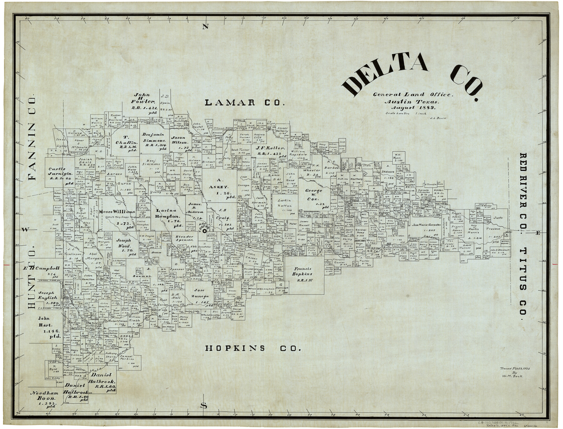
Delta Co.
-
Map/Doc
4931
-
Collection
General Map Collection
-
Object Dates
1889 (Creation Date)
-
People and Organizations
Texas General Land Office (Publisher)
J.L. Blain (Compiler)
J.L. Blain (Draftsman)
-
Counties
Delta
-
Subjects
County
-
Height x Width
29.2 x 38.3 inches
74.2 x 97.3 cm
-
Comments
Traced February 29, 1932 by W. M. Beck.
Part of: General Map Collection
Township No. 5 South Range No. 14 West of the Indian Meridian

Print $4.00
- Digital $50.00
Township No. 5 South Range No. 14 West of the Indian Meridian
1875
Size 17.8 x 22.8 inches
Map/Doc 75147
Brewster County Working Sketch 57

Print $20.00
- Digital $50.00
Brewster County Working Sketch 57
1954
Size 19.6 x 20.8 inches
Map/Doc 67658
Flight Mission No. CUG-2P, Frame 85, Kleberg County

Print $20.00
- Digital $50.00
Flight Mission No. CUG-2P, Frame 85, Kleberg County
1956
Size 18.5 x 22.2 inches
Map/Doc 86217
Map of Asia (Inset: Palestine)

Print $20.00
- Digital $50.00
Map of Asia (Inset: Palestine)
1844
Size 12.1 x 19.0 inches
Map/Doc 93548
Kimble County Sketch File 16

Print $30.00
- Digital $50.00
Kimble County Sketch File 16
1886
Size 8.5 x 7.9 inches
Map/Doc 28942
Atascosa County Rolled Sketch 18

Print $20.00
- Digital $50.00
Atascosa County Rolled Sketch 18
1955
Size 17.6 x 23.9 inches
Map/Doc 5098
Brewster County Sketch File N-23

Print $6.00
- Digital $50.00
Brewster County Sketch File N-23
1951
Size 14.4 x 9.0 inches
Map/Doc 15697
Donley County Sketch File 18 (2a)

Print $2.00
- Digital $50.00
Donley County Sketch File 18 (2a)
Size 10.3 x 8.0 inches
Map/Doc 21255
Hockley County Rolled Sketch 7

Print $40.00
- Digital $50.00
Hockley County Rolled Sketch 7
Size 41.4 x 56.6 inches
Map/Doc 9176
Randall County Sketch File 2

Print $4.00
- Digital $50.00
Randall County Sketch File 2
1913
Size 7.3 x 8.8 inches
Map/Doc 34961
San Patricio County Rolled Sketch 49

Print $20.00
- Digital $50.00
San Patricio County Rolled Sketch 49
1979
Size 19.7 x 17.7 inches
Map/Doc 7734
Chambers County Rolled Sketch CL

Print $40.00
- Digital $50.00
Chambers County Rolled Sketch CL
1909
Size 56.2 x 21.0 inches
Map/Doc 8610
You may also like
Shackelford County Sketch File 10

Print $20.00
- Digital $50.00
Shackelford County Sketch File 10
1918
Size 31.4 x 19.9 inches
Map/Doc 12316

Harris County NRC Article 33.136 Sketch 19

Print $50.00
- Digital $50.00
Harris County NRC Article 33.136 Sketch 19
2014
Size 24.6 x 36.6 inches
Map/Doc 95334
Crosby County Sketch File B

Print $20.00
- Digital $50.00
Crosby County Sketch File B
1877
Size 21.9 x 21.0 inches
Map/Doc 11259
Jeff Davis County Texas

Print $20.00
- Digital $50.00
Jeff Davis County Texas
Size 16.1 x 21.1 inches
Map/Doc 4572
Concho County Rolled Sketch 17

Print $20.00
- Digital $50.00
Concho County Rolled Sketch 17
1961
Size 35.2 x 26.5 inches
Map/Doc 78462
Sutton County Rolled Sketch 59

Print $40.00
- Digital $50.00
Sutton County Rolled Sketch 59
1960
Size 86.1 x 42.5 inches
Map/Doc 9977
Pecos County Rolled Sketch 129

Print $40.00
- Digital $50.00
Pecos County Rolled Sketch 129
Size 52.8 x 45.3 inches
Map/Doc 9727
Flight Mission No. DAG-18K, Frame 179, Matagorda County

Print $20.00
- Digital $50.00
Flight Mission No. DAG-18K, Frame 179, Matagorda County
1952
Size 16.2 x 16.0 inches
Map/Doc 86371

Duval County Sketch File 45a

Print $9.00
- Digital $50.00
Duval County Sketch File 45a
Size 14.5 x 9.0 inches
Map/Doc 21396
Hopkins County Sketch File 5

Print $4.00
- Digital $50.00
Hopkins County Sketch File 5
Size 10.3 x 8.2 inches
Map/Doc 26687