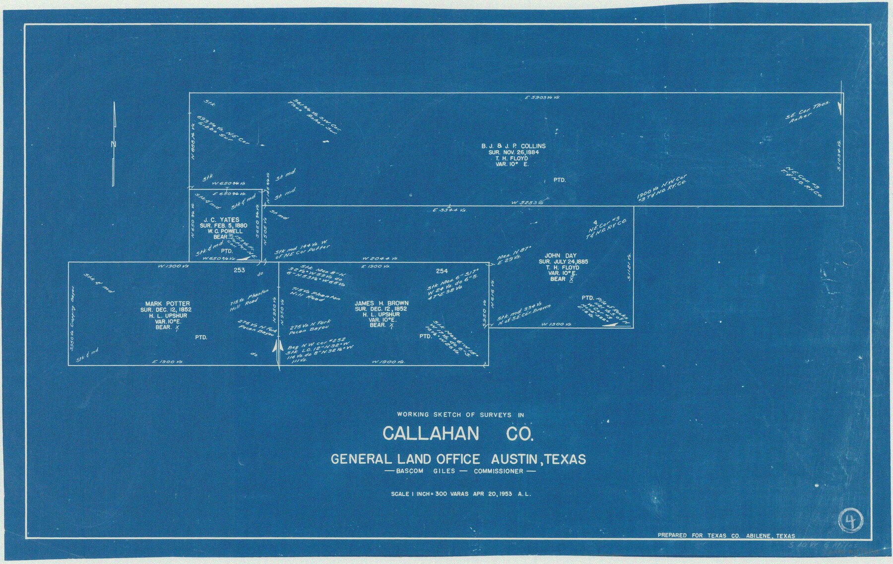
Callahan County Working Sketch 4
-
Map/Doc
67886
-
Collection
General Map Collection
-
Object Dates
4/20/1953 (Creation Date)
-
Counties
Callahan
-
Subjects
Surveying Working Sketch
-
Height x Width
17.1 x 27.0 inches
43.4 x 68.6 cm
-
Scale
1" = 300 varas
Part of: General Map Collection
Refugio County Working Sketch 13

Print $20.00
- Digital $50.00
Refugio County Working Sketch 13
1961
Size 23.8 x 29.8 inches
Map/Doc 63522
Travis County Working Sketch 13

Print $20.00
- Digital $50.00
Travis County Working Sketch 13
1930
Size 20.5 x 27.3 inches
Map/Doc 69397
Nueces County Sketch File 35

Print $2.00
- Digital $50.00
Nueces County Sketch File 35
1913
Size 13.1 x 4.8 inches
Map/Doc 32613
[Jose Antonio Sepulveda grant]
![349, [Jose Antonio Sepulveda grant], General Map Collection](https://historictexasmaps.com/wmedia_w700/maps/349.tif.jpg)
Print $2.00
- Digital $50.00
[Jose Antonio Sepulveda grant]
Size 5.9 x 5.7 inches
Map/Doc 349
Flight Mission No. CRC-2R, Frame 3, Chambers County

Print $20.00
- Digital $50.00
Flight Mission No. CRC-2R, Frame 3, Chambers County
1956
Size 18.8 x 22.5 inches
Map/Doc 84722
Cameron County Boundary File 4

Print $42.00
- Digital $50.00
Cameron County Boundary File 4
Size 10.4 x 8.2 inches
Map/Doc 51110

Lampasas County Working Sketch 19

Print $40.00
- Digital $50.00
Lampasas County Working Sketch 19
1979
Size 43.8 x 48.3 inches
Map/Doc 70296
Maverick County Working Sketch 7

Print $20.00
- Digital $50.00
Maverick County Working Sketch 7
1959
Size 22.4 x 21.0 inches
Map/Doc 70899
Orange County Working Sketch 52

Print $20.00
- Digital $50.00
Orange County Working Sketch 52
2006
Size 31.9 x 47.5 inches
Map/Doc 83069
Upton County Sketch File 6

Print $10.00
- Digital $50.00
Upton County Sketch File 6
1909
Size 11.3 x 8.6 inches
Map/Doc 38815
Flight Mission No. BQR-9K, Frame 16, Brazoria County

Print $20.00
- Digital $50.00
Flight Mission No. BQR-9K, Frame 16, Brazoria County
1952
Size 18.8 x 22.5 inches
Map/Doc 84045
You may also like
Hockley County

Print $20.00
- Digital $50.00
Hockley County
1914
Size 25.9 x 23.1 inches
Map/Doc 4980
Llano County Sketch File 18

Print $20.00
- Digital $50.00
Llano County Sketch File 18
1949
Size 22.3 x 20.0 inches
Map/Doc 12013
Hunt County Working Sketch 11

Print $20.00
- Digital $50.00
Hunt County Working Sketch 11
2002
Size 32.1 x 29.6 inches
Map/Doc 66358
McCulloch County Working Sketch 4

Print $20.00
- Digital $50.00
McCulloch County Working Sketch 4
1956
Size 25.3 x 22.8 inches
Map/Doc 70679
Jackson County Sketch File 21a

Print $20.00
- Digital $50.00
Jackson County Sketch File 21a
1937
Size 25.7 x 35.4 inches
Map/Doc 11843
Republic of Texas and Boundaries as Claimed by Texas from Decr. 19th, 1836 to Novr. 25th, 1850

Print $20.00
- Digital $50.00
Republic of Texas and Boundaries as Claimed by Texas from Decr. 19th, 1836 to Novr. 25th, 1850
Size 18.4 x 20.8 inches
Map/Doc 92063
Cameron County NRC Article 33.136 Sketch 1

Print $3.00
- Digital $50.00
Cameron County NRC Article 33.136 Sketch 1
2001
Size 11.3 x 17.4 inches
Map/Doc 61558
Nueces County Sketch File 62

Print $4.00
- Digital $50.00
Nueces County Sketch File 62
1936
Size 8.6 x 14.3 inches
Map/Doc 32971

Val Verde County Sketch File C

Print $62.00
- Digital $50.00
Val Verde County Sketch File C
1898
Size 15.5 x 19.8 inches
Map/Doc 12545
Motley County Sketch File 13 (N)

Print $10.00
- Digital $50.00
Motley County Sketch File 13 (N)
1911
Size 11.1 x 8.6 inches
Map/Doc 32043
Baie de Galvez-Town

Print $20.00
- Digital $50.00
Baie de Galvez-Town
1820
Size 10.3 x 12.9 inches
Map/Doc 95832