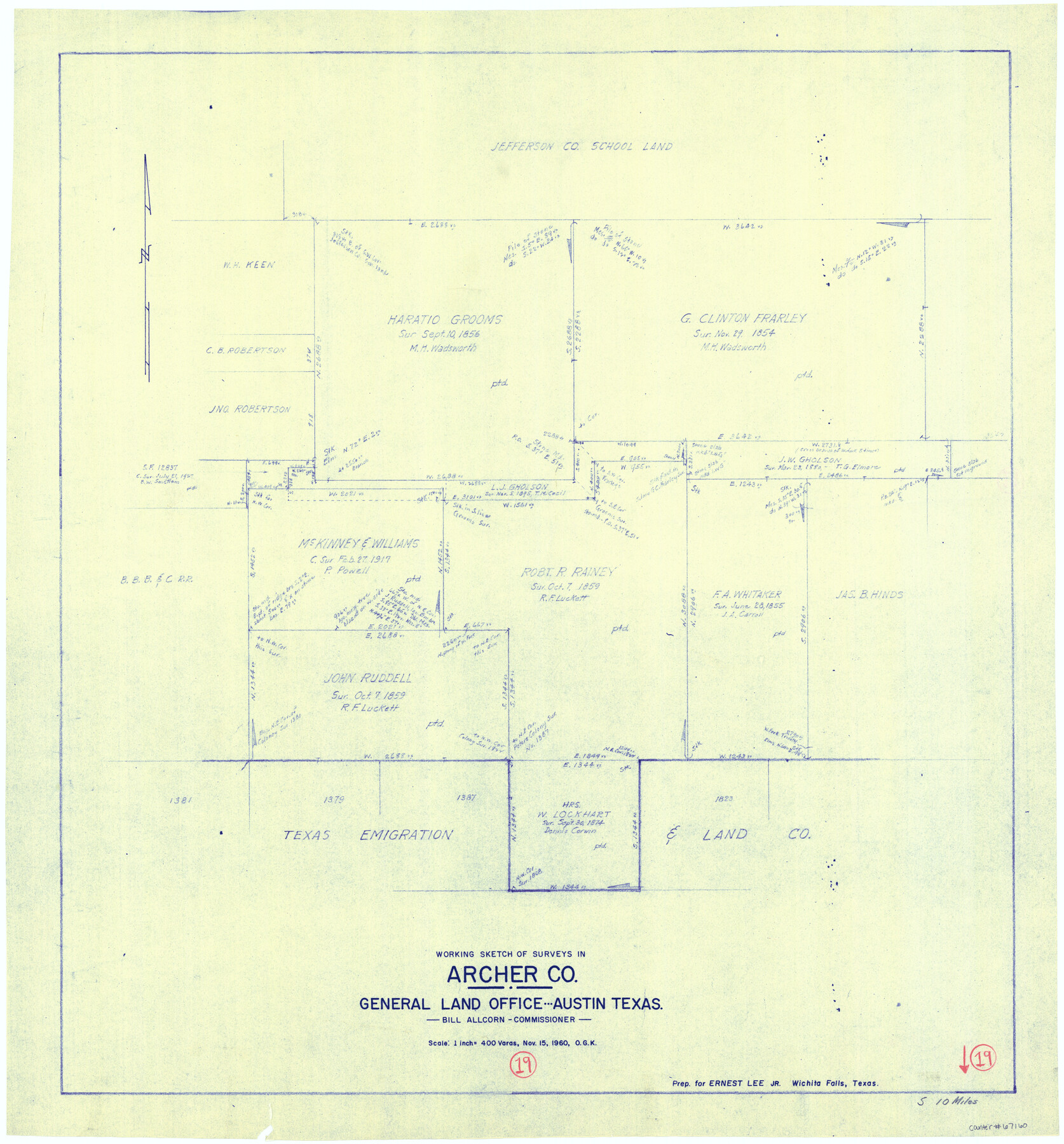
Archer County Working Sketch 19
-
Map/Doc
67160
-
Collection
General Map Collection
-
Object Dates
11/15/1960 (Creation Date)
-
People and Organizations
Bill Allcorn (GLO Commissioner)
Otto G. Kurio (Draftsman)
-
Counties
Archer
-
Subjects
Surveying Working Sketch
-
Height x Width
29.6 x 27.5 inches
75.2 x 69.9 cm
-
Scale
1" = 400 varas
-
Comments
Surveys located about 10 miles South of Archer City, Texas.
Part of: General Map Collection
Travis County Working Sketch 3

Print $20.00
- Digital $50.00
Travis County Working Sketch 3
1906
Size 19.5 x 15.0 inches
Map/Doc 69387
Travels to the source of the Missouri River and across the American Continent to the Pacific Ocean - Vol. 1

Travels to the source of the Missouri River and across the American Continent to the Pacific Ocean - Vol. 1
1815
Map/Doc 97411
Calhoun County Working Sketch 11

Print $20.00
- Digital $50.00
Calhoun County Working Sketch 11
1952
Size 43.1 x 34.9 inches
Map/Doc 67827
Lavaca County Sketch File 22

Print $28.00
- Digital $50.00
Lavaca County Sketch File 22
1959
Size 14.2 x 8.7 inches
Map/Doc 29654
Ector County Working Sketch 23

Print $40.00
- Digital $50.00
Ector County Working Sketch 23
1961
Size 55.9 x 43.3 inches
Map/Doc 68866
Gaines County Rolled Sketch G3A

Print $20.00
- Digital $50.00
Gaines County Rolled Sketch G3A
1902
Size 22.5 x 31.1 inches
Map/Doc 5947
Flight Mission No. BRA-8M, Frame 145, Jefferson County

Print $20.00
- Digital $50.00
Flight Mission No. BRA-8M, Frame 145, Jefferson County
1953
Size 16.0 x 15.9 inches
Map/Doc 85637
Aransas County NRC Article 33.136 Sketch 13

Print $24.00
- Digital $50.00
Aransas County NRC Article 33.136 Sketch 13
Size 24.0 x 36.0 inches
Map/Doc 94514
Duval County Working Sketch 57

Print $20.00
- Digital $50.00
Duval County Working Sketch 57
1990
Size 30.3 x 25.4 inches
Map/Doc 68781
Kendall County Rolled Sketch 3

Print $9.00
- Digital $50.00
Kendall County Rolled Sketch 3
1858
Size 10.0 x 15.3 inches
Map/Doc 46424
Presidio County Sketch File 31

Print $20.00
- Digital $50.00
Presidio County Sketch File 31
Size 11.4 x 20.8 inches
Map/Doc 11712
Orange County Rolled Sketch 16

Print $20.00
- Digital $50.00
Orange County Rolled Sketch 16
Size 42.2 x 30.4 inches
Map/Doc 41813
You may also like
Matagorda County Working Sketch 32

Print $20.00
- Digital $50.00
Matagorda County Working Sketch 32
1993
Size 28.4 x 33.5 inches
Map/Doc 70890
Right of Way and Track Map of The Missouri, Kansas & Texas Railway of Texas

Print $40.00
- Digital $50.00
Right of Way and Track Map of The Missouri, Kansas & Texas Railway of Texas
1918
Size 25.4 x 75.5 inches
Map/Doc 64533
Pecos County Sketch

Print $20.00
- Digital $50.00
Pecos County Sketch
Size 34.2 x 23.5 inches
Map/Doc 91642
El Paso County Working Sketch 4

Print $20.00
- Digital $50.00
El Paso County Working Sketch 4
1916
Size 21.4 x 37.3 inches
Map/Doc 69026
Flight Mission No. DIX-5P, Frame 151, Aransas County

Print $20.00
- Digital $50.00
Flight Mission No. DIX-5P, Frame 151, Aransas County
1956
Size 17.8 x 18.2 inches
Map/Doc 83813
Greenville, Tex., County Seat of Hunt County

Print $20.00
Greenville, Tex., County Seat of Hunt County
1886
Size 17.3 x 24.9 inches
Map/Doc 89089
Crockett County Rolled Sketch 88M

Print $20.00
- Digital $50.00
Crockett County Rolled Sketch 88M
1964
Size 25.2 x 34.2 inches
Map/Doc 5629
Gillespie County Working Sketch 11

Print $20.00
- Digital $50.00
Gillespie County Working Sketch 11
2007
Size 27.8 x 38.0 inches
Map/Doc 87212
Comal County Sketch File 11

Print $4.00
- Digital $50.00
Comal County Sketch File 11
1848
Size 12.8 x 8.5 inches
Map/Doc 19022
Map of Bastrop County, Texas

Print $20.00
- Digital $50.00
Map of Bastrop County, Texas
1879
Size 25.2 x 23.3 inches
Map/Doc 693

Rusk County Sketch File 10

Print $4.00
Rusk County Sketch File 10
1849
Size 8.1 x 7.3 inches
Map/Doc 35507