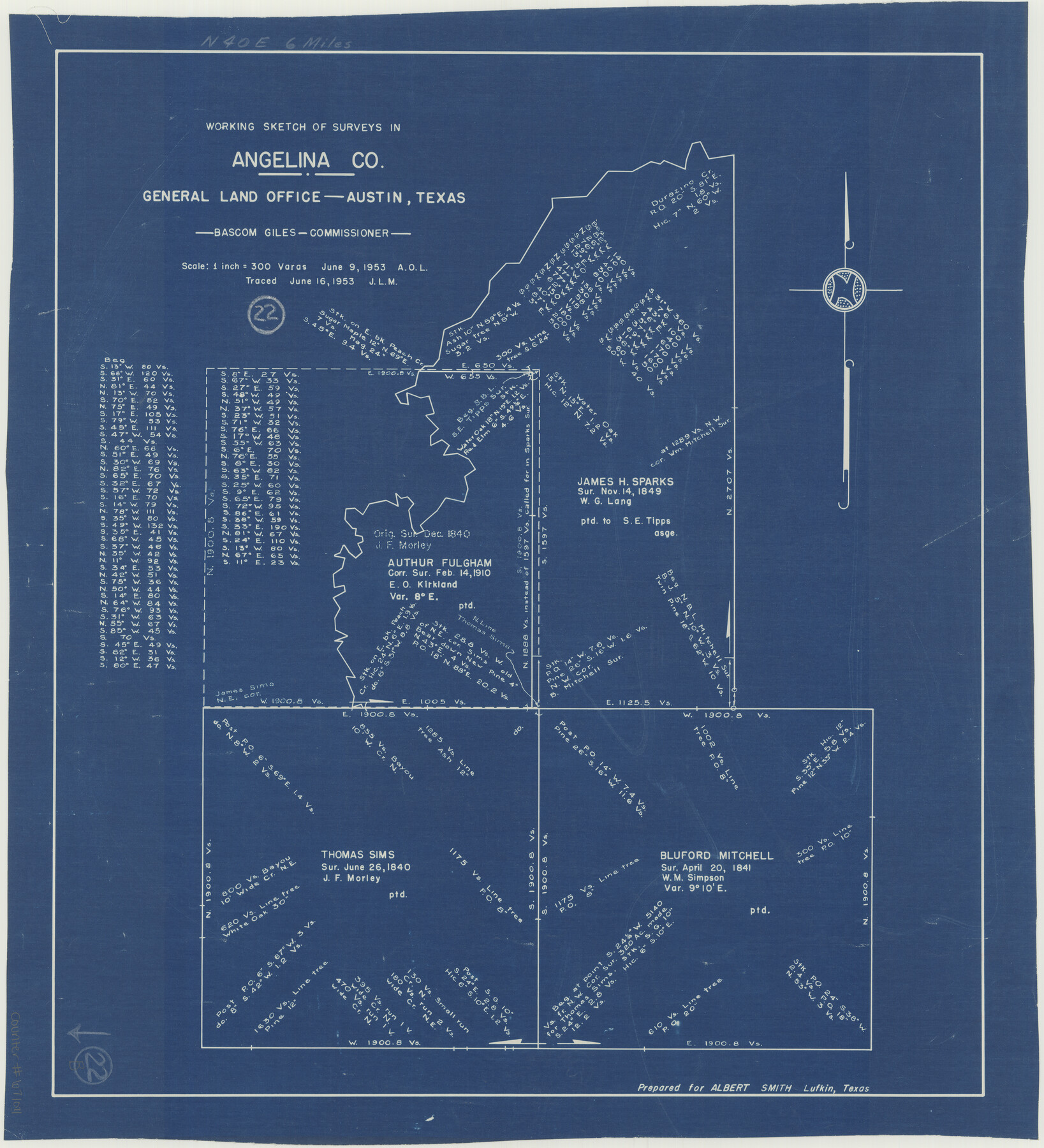
Angelina County Working Sketch 22b
-
Map/Doc
67104
-
Collection
General Map Collection
-
Object Dates
6/9/1953 (Creation Date)
6/16/1953 (Tracing Date)
-
People and Organizations
Bascom Giles (GLO Commissioner)
-
Counties
Angelina
-
Subjects
Surveying Working Sketch
-
Height x Width
21.5 x 19.6 inches
54.6 x 49.8 cm
-
Scale
1" = 300 varas
-
Comments
Surveys located about six miles North 40 degrees East from Lufkin, Texas.
Part of: General Map Collection
Flight Mission No. DIX-6P, Frame 133, Aransas County

Print $20.00
- Digital $50.00
Flight Mission No. DIX-6P, Frame 133, Aransas County
1956
Size 19.6 x 23.3 inches
Map/Doc 83839
DeWitt County Working Sketch 9

Print $20.00
- Digital $50.00
DeWitt County Working Sketch 9
1979
Size 15.7 x 23.4 inches
Map/Doc 68599
Terrell County Working Sketch 33

Print $20.00
- Digital $50.00
Terrell County Working Sketch 33
1945
Size 16.1 x 31.6 inches
Map/Doc 62125
[G. C. & S. F. Ry. Alinement (sic) and Right of Way Map of Dallas Branch, Johnson County, Texas]
![64651, [G. C. & S. F. Ry. Alinement (sic) and Right of Way Map of Dallas Branch, Johnson County, Texas], General Map Collection](https://historictexasmaps.com/wmedia_w700/maps/64651.tif.jpg)
Print $40.00
- Digital $50.00
[G. C. & S. F. Ry. Alinement (sic) and Right of Way Map of Dallas Branch, Johnson County, Texas]
1926
Size 37.6 x 124.3 inches
Map/Doc 64651
[Maps of surveys in Reeves & Culberson Cos]
![61136, [Maps of surveys in Reeves & Culberson Cos], General Map Collection](https://historictexasmaps.com/wmedia_w700/maps/61136.tif.jpg)
Print $20.00
- Digital $50.00
[Maps of surveys in Reeves & Culberson Cos]
1937
Size 30.5 x 24.7 inches
Map/Doc 61136
Map of the Passo Cavallo

Print $20.00
- Digital $50.00
Map of the Passo Cavallo
1853
Size 18.0 x 27.0 inches
Map/Doc 73011
Zapata County Rolled Sketch 22

Print $20.00
- Digital $50.00
Zapata County Rolled Sketch 22
1958
Size 29.2 x 21.5 inches
Map/Doc 8317
Jeff Davis County Boundary File 1a

Print $8.00
- Digital $50.00
Jeff Davis County Boundary File 1a
Size 14.3 x 8.8 inches
Map/Doc 55501
Crane County Rolled Sketch 7

Print $20.00
- Digital $50.00
Crane County Rolled Sketch 7
1927
Size 33.4 x 44.8 inches
Map/Doc 8679
Cooke County Working Sketch 18

Print $20.00
- Digital $50.00
Cooke County Working Sketch 18
1952
Size 23.5 x 19.6 inches
Map/Doc 68255
Polk County Working Sketch 42

Print $20.00
- Digital $50.00
Polk County Working Sketch 42
1992
Size 30.8 x 35.7 inches
Map/Doc 71659
Carson County Working Sketch 3

Print $20.00
- Digital $50.00
Carson County Working Sketch 3
1922
Size 18.3 x 26.3 inches
Map/Doc 67874
You may also like
Terrell County Working Sketch 22

Print $20.00
- Digital $50.00
Terrell County Working Sketch 22
1937
Size 28.8 x 26.5 inches
Map/Doc 62172
County Map of the State of Texas Showing also portions of the Adjoining States and Territories (Inset: Plan of Galveston and Vicinity)

Print $20.00
- Digital $50.00
County Map of the State of Texas Showing also portions of the Adjoining States and Territories (Inset: Plan of Galveston and Vicinity)
1873
Size 15.5 x 23.1 inches
Map/Doc 93696
Lavaca County Rolled Sketch 5

Print $40.00
- Digital $50.00
Lavaca County Rolled Sketch 5
Size 37.0 x 49.1 inches
Map/Doc 10288
Llano County Working Sketch 7

Print $20.00
- Digital $50.00
Llano County Working Sketch 7
1968
Size 30.9 x 30.3 inches
Map/Doc 70625
Real County Rolled Sketch JCA

Print $20.00
- Digital $50.00
Real County Rolled Sketch JCA
Size 27.9 x 36.5 inches
Map/Doc 7470
Pecos County Rolled Sketch 184

Print $20.00
- Digital $50.00
Pecos County Rolled Sketch 184
1977
Size 44.4 x 30.0 inches
Map/Doc 7303
Colorado County Rolled Sketch 3

Print $20.00
- Digital $50.00
Colorado County Rolled Sketch 3
1943
Size 43.6 x 40.2 inches
Map/Doc 8642
Flight Mission No. CLL-3N, Frame 34, Willacy County

Print $20.00
- Digital $50.00
Flight Mission No. CLL-3N, Frame 34, Willacy County
1954
Size 18.6 x 22.2 inches
Map/Doc 87092
Map of a part of Fisher and Miller's Colony - Harvey's District

Print $20.00
- Digital $50.00
Map of a part of Fisher and Miller's Colony - Harvey's District
1856
Size 18.6 x 24.5 inches
Map/Doc 4658
General Highway Map, Matagorda County, Texas

Print $20.00
General Highway Map, Matagorda County, Texas
1961
Size 24.8 x 18.2 inches
Map/Doc 79585
[West part of H. T. & B. Block A and surrounding surveys]
![90811, [West part of H. T. & B. Block A and surrounding surveys], Twichell Survey Records](https://historictexasmaps.com/wmedia_w700/maps/90811-1.tif.jpg)
Print $2.00
- Digital $50.00
[West part of H. T. & B. Block A and surrounding surveys]
Size 13.8 x 9.2 inches
Map/Doc 90811
Childress County Sketch File 19

Print $4.00
- Digital $50.00
Childress County Sketch File 19
Size 14.1 x 8.7 inches
Map/Doc 18294