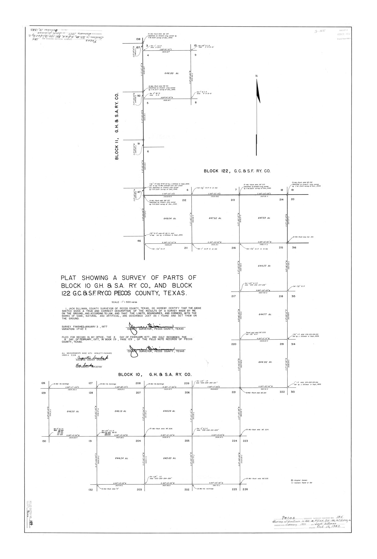
Pecos County Rolled Sketch 184
Plat showing a survey of parts of Block 10, G. H. & S. A. Ry. Co., and Block 122, G. C. & S. F. Ry. Co., Pecos County, Texas
-
Map/Doc
7303
-
Collection
General Map Collection
-
Object Dates
1977/1/3 (Creation Date)
1982/10/12 (File Date)
-
People and Organizations
Jack Silliman (Surveyor/Engineer)
-
Counties
Pecos
-
Subjects
Surveying Rolled Sketch
-
Height x Width
44.4 x 30.0 inches
112.8 x 76.2 cm
-
Scale
1" = 500 varas
Part of: General Map Collection
Cottle County Working Sketch 17

Print $20.00
- Digital $50.00
Cottle County Working Sketch 17
1975
Size 32.5 x 34.1 inches
Map/Doc 68327
Map of the United States, the British Provinces, Mexico &c. Showing the Routes of the U.S. Mail Steam Packets to California and a Plan of the Gold Region

Print $20.00
- Digital $50.00
Map of the United States, the British Provinces, Mexico &c. Showing the Routes of the U.S. Mail Steam Packets to California and a Plan of the Gold Region
Size 19.6 x 26.6 inches
Map/Doc 95695
Crane County Sketch File 19

Print $4.00
- Digital $50.00
Crane County Sketch File 19
1927
Size 11.4 x 8.8 inches
Map/Doc 19584
Comanche County

Print $20.00
- Digital $50.00
Comanche County
1896
Size 41.7 x 44.8 inches
Map/Doc 4736
Kinney County Working Sketch 31

Print $20.00
- Digital $50.00
Kinney County Working Sketch 31
1961
Size 30.9 x 47.3 inches
Map/Doc 70213
Hill County Boundary File 2

Print $18.00
- Digital $50.00
Hill County Boundary File 2
Size 10.6 x 8.1 inches
Map/Doc 54734
Webb County Working Sketch 17

Print $20.00
- Digital $50.00
Webb County Working Sketch 17
1923
Size 13.0 x 20.5 inches
Map/Doc 72382
Hays County Working Sketch 11

Print $20.00
- Digital $50.00
Hays County Working Sketch 11
1950
Size 22.7 x 33.1 inches
Map/Doc 66085
Terrell County Working Sketch 17

Print $20.00
- Digital $50.00
Terrell County Working Sketch 17
1928
Size 15.2 x 32.3 inches
Map/Doc 62166
Van Zandt County Sketch File 20a

Print $4.00
- Digital $50.00
Van Zandt County Sketch File 20a
1858
Size 12.9 x 8.0 inches
Map/Doc 39428
Gregg County Sketch File 1F

Print $4.00
- Digital $50.00
Gregg County Sketch File 1F
1850
Size 12.2 x 7.8 inches
Map/Doc 24547
Young County Rolled Sketch 10

Print $20.00
- Digital $50.00
Young County Rolled Sketch 10
1921
Size 27.3 x 40.1 inches
Map/Doc 8298
You may also like

Real County Working Sketch 32

Print $20.00
- Digital $50.00
Real County Working Sketch 32
1948
Size 15.6 x 19.6 inches
Map/Doc 71924
Bandera County Sketch File 28

Print $40.00
- Digital $50.00
Bandera County Sketch File 28
Size 23.5 x 20.0 inches
Map/Doc 10897
Terry County Sketch

Print $20.00
- Digital $50.00
Terry County Sketch
1954
Size 13.7 x 20.6 inches
Map/Doc 92413
General Highway Map. Detail of Cities and Towns in Taylor County, Texas [Abilene and vicinity]
![79673, General Highway Map. Detail of Cities and Towns in Taylor County, Texas [Abilene and vicinity], Texas State Library and Archives](https://historictexasmaps.com/wmedia_w700/maps/79673.tif.jpg)
Print $20.00
General Highway Map. Detail of Cities and Towns in Taylor County, Texas [Abilene and vicinity]
1961
Size 18.2 x 24.8 inches
Map/Doc 79673
La Salle County Working Sketch 20

Print $20.00
- Digital $50.00
La Salle County Working Sketch 20
1941
Size 23.7 x 29.9 inches
Map/Doc 70321
Tom Green County Sketch File 85

Print $4.00
- Digital $50.00
Tom Green County Sketch File 85
1912
Size 11.4 x 9.0 inches
Map/Doc 38256
Texas, Corpus Christi Bay, Mustang Island

Print $40.00
- Digital $50.00
Texas, Corpus Christi Bay, Mustang Island
1934
Size 49.6 x 35.0 inches
Map/Doc 73462
[Surveys along the Salado and Lampasas Rivers and Saltillo Creek]
![362, [Surveys along the Salado and Lampasas Rivers and Saltillo Creek], General Map Collection](https://historictexasmaps.com/wmedia_w700/maps/362.tif.jpg)
Print $2.00
- Digital $50.00
[Surveys along the Salado and Lampasas Rivers and Saltillo Creek]
1845
Size 13.1 x 7.8 inches
Map/Doc 362
McLennan County Sketch File 8

Print $14.00
- Digital $50.00
McLennan County Sketch File 8
1858
Size 12.4 x 7.7 inches
Map/Doc 31251
Menard County Boundary File 7

Print $6.00
- Digital $50.00
Menard County Boundary File 7
Size 10.5 x 8.1 inches
Map/Doc 57089
Aransas County Rolled Sketch 25

Print $20.00
- Digital $50.00
Aransas County Rolled Sketch 25
1983
Size 18.4 x 24.5 inches
Map/Doc 5061