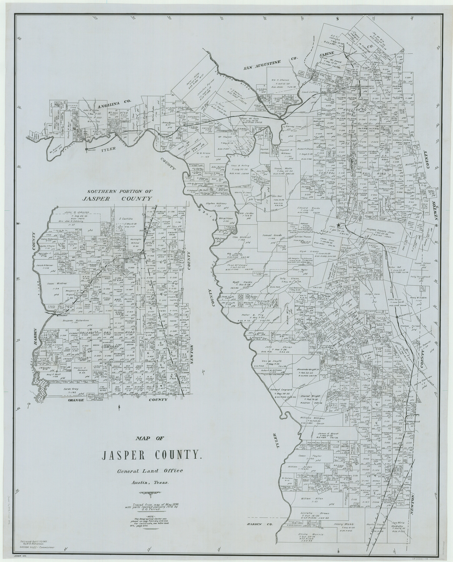
Map of Jasper County
-
Map/Doc
66879
-
Collection
General Map Collection
-
Object Dates
1898 (Creation Date)
-
People and Organizations
Texas General Land Office (Publisher)
Bascom Giles (GLO Commissioner)
-
Counties
Jasper
-
Subjects
County
-
Height x Width
49.1 x 39.6 inches
124.7 x 100.6 cm
-
Comments
Traced from Map of May 1898 with parts revised in Jan 1918 by O. O. Terrell.
Retraced April 10, 1943 by W. G. Bohannon.
Part of: General Map Collection
Martin County Working Sketch 13

Print $40.00
- Digital $50.00
Martin County Working Sketch 13
1971
Size 50.8 x 37.5 inches
Map/Doc 70831
Map of Hemisfair '68 and Downtown San Antonio compliments of the Pearl Brewing Company

Print $3.00
- Digital $50.00
Map of Hemisfair '68 and Downtown San Antonio compliments of the Pearl Brewing Company
1968
Size 5.9 x 11.3 inches
Map/Doc 94792
Martin County Sketch File 10

Print $50.00
- Digital $50.00
Martin County Sketch File 10
Size 11.2 x 8.8 inches
Map/Doc 30644
Irion County Rolled Sketch 24

Print $40.00
- Digital $50.00
Irion County Rolled Sketch 24
Size 49.4 x 37.4 inches
Map/Doc 9257
Val Verde County Sketch File 6

Print $32.00
- Digital $50.00
Val Verde County Sketch File 6
1889
Size 19.6 x 16.1 inches
Map/Doc 12562
Flight Mission No. DQN-7K, Frame 11, Calhoun County

Print $20.00
- Digital $50.00
Flight Mission No. DQN-7K, Frame 11, Calhoun County
1953
Size 18.6 x 22.3 inches
Map/Doc 84462
El Paso County Working Sketch 40

Print $20.00
- Digital $50.00
El Paso County Working Sketch 40
1992
Size 21.5 x 24.0 inches
Map/Doc 69062
Brewster County Sketch File D

Print $4.00
- Digital $50.00
Brewster County Sketch File D
1938
Size 14.5 x 8.8 inches
Map/Doc 15738
Harrison County Working Sketch 6

Print $20.00
- Digital $50.00
Harrison County Working Sketch 6
1954
Size 27.6 x 38.7 inches
Map/Doc 66026
Cass County Sketch File 6

Print $4.00
- Digital $50.00
Cass County Sketch File 6
1852
Size 8.4 x 8.8 inches
Map/Doc 17406
Aransas County Sketch File 31

Print $46.00
- Digital $50.00
Aransas County Sketch File 31
1919
Size 14.2 x 8.7 inches
Map/Doc 13274
Reagan County Sketch File 1

Print $20.00
- Digital $50.00
Reagan County Sketch File 1
1914
Size 24.3 x 30.3 inches
Map/Doc 12210
You may also like
Shelby County Sketch File 3

Print $4.00
- Digital $50.00
Shelby County Sketch File 3
1849
Size 11.9 x 7.9 inches
Map/Doc 36595
Karnes County Rolled Sketch 3

Print $20.00
- Digital $50.00
Karnes County Rolled Sketch 3
1959
Size 27.9 x 41.6 inches
Map/Doc 6454
General Highway Map, Falls County, Texas

Print $20.00
General Highway Map, Falls County, Texas
1940
Size 18.5 x 24.7 inches
Map/Doc 79088
Kleberg County Rolled Sketch 10-31

Print $20.00
- Digital $50.00
Kleberg County Rolled Sketch 10-31
1952
Size 37.9 x 40.3 inches
Map/Doc 9398
Flight Mission No. CGI-3N, Frame 120, Cameron County

Print $20.00
- Digital $50.00
Flight Mission No. CGI-3N, Frame 120, Cameron County
1954
Size 18.8 x 22.3 inches
Map/Doc 84593
Terrell County Rolled Sketch 31

Print $20.00
- Digital $50.00
Terrell County Rolled Sketch 31
1931
Size 24.4 x 28.4 inches
Map/Doc 7937
Sherman County Rolled Sketch 14

Print $20.00
- Digital $50.00
Sherman County Rolled Sketch 14
1975
Size 17.4 x 17.7 inches
Map/Doc 7795
[Surveys along Verde and Bandera Creeks]
![289, [Surveys along Verde and Bandera Creeks], General Map Collection](https://historictexasmaps.com/wmedia_w700/maps/289.tif.jpg)
Print $2.00
- Digital $50.00
[Surveys along Verde and Bandera Creeks]
1846
Size 10.0 x 8.0 inches
Map/Doc 289
Brazoria County Working Sketch 19

Print $40.00
- Digital $50.00
Brazoria County Working Sketch 19
1951
Size 50.3 x 42.3 inches
Map/Doc 67504
El Paso County Sketch File 36

Print $2.00
- Digital $50.00
El Paso County Sketch File 36
1984
Size 11.6 x 9.0 inches
Map/Doc 24123

Lampasas County Working Sketch 5

Print $20.00
- Digital $50.00
Lampasas County Working Sketch 5
1947
Size 25.6 x 31.8 inches
Map/Doc 70282