Hays County Rolled Sketch 26
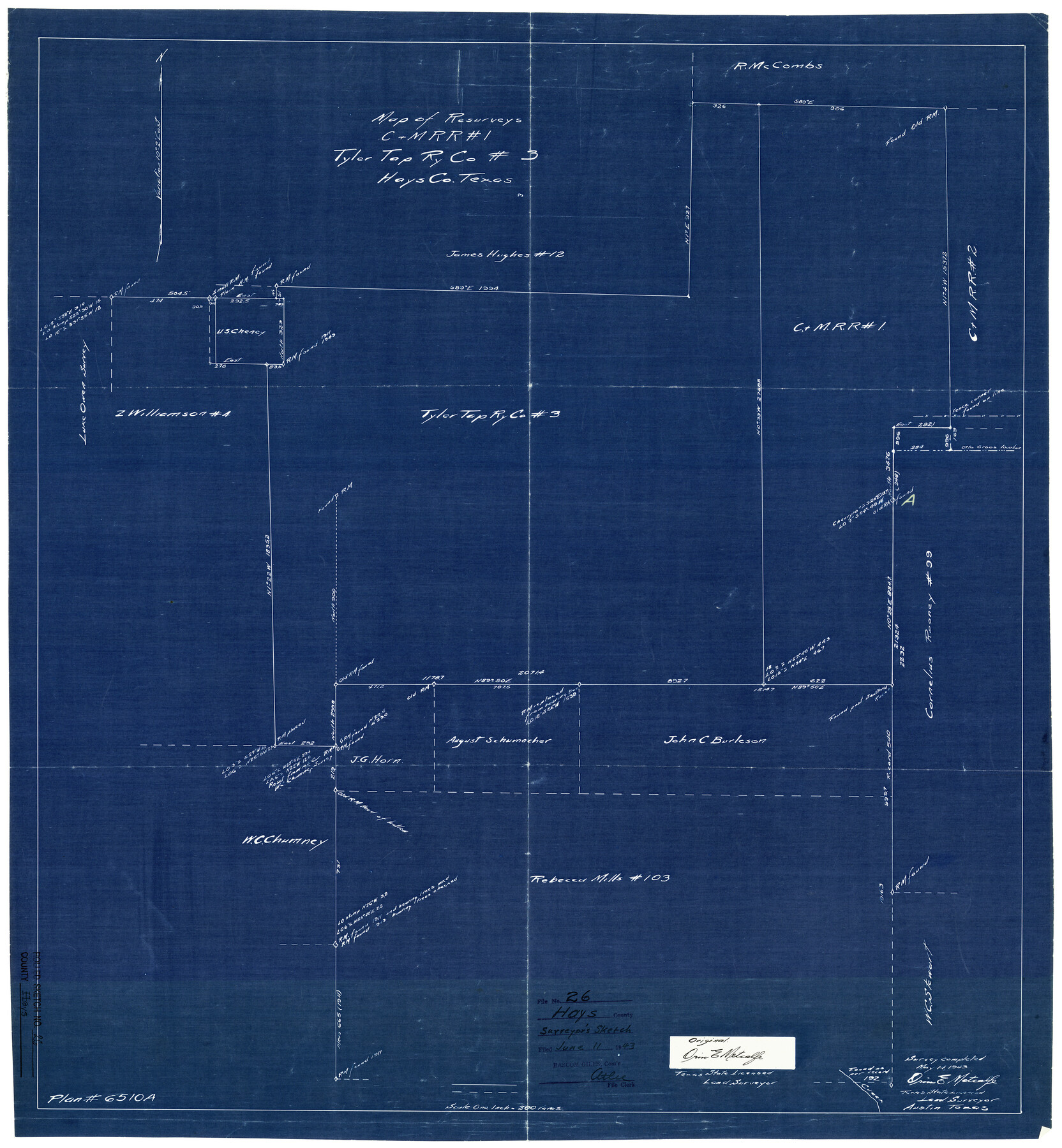
Map of resurvey C. & M. R.R. # 1, Tyler Tap Ry. Co. # 3, Hays Co., Texas
-
Map/Doc
6182
-
Collection
General Map Collection
-
Object Dates
5/14/1943 (Creation Date)
6/11/1943 (File Date)
-
People and Organizations
Orin E. Metcalfe (Surveyor/Engineer)
-
Counties
Hays
-
Subjects
Surveying Rolled Sketch
-
Height x Width
27.7 x 25.6 inches
70.4 x 65.0 cm
-
Medium
blueprint/diazo
-
Scale
1" = 200 varas
-
Comments
See Hays County Sketch File 32 (26264) for report.
Related maps
Hays County Sketch File 32

Print $8.00
- Digital $50.00
Hays County Sketch File 32
Size 14.3 x 8.8 inches
Map/Doc 26264
Part of: General Map Collection
Burnet County Working Sketch 12

Print $20.00
- Digital $50.00
Burnet County Working Sketch 12
1976
Size 17.3 x 19.9 inches
Map/Doc 67855
Pecos County Rolled Sketch 141

Print $40.00
- Digital $50.00
Pecos County Rolled Sketch 141
1927
Size 60.5 x 20.4 inches
Map/Doc 10722
Terrell County Working Sketch 55

Print $20.00
- Digital $50.00
Terrell County Working Sketch 55
1959
Size 25.9 x 43.4 inches
Map/Doc 62148
Leon County Working Sketch 44

Print $40.00
- Digital $50.00
Leon County Working Sketch 44
1980
Size 42.8 x 59.8 inches
Map/Doc 70443
Kenedy County Working Sketch 2a

Print $20.00
- Digital $50.00
Kenedy County Working Sketch 2a
1907
Size 22.2 x 20.9 inches
Map/Doc 70003
Flight Mission No. DAG-23K, Frame 14, Matagorda County

Print $20.00
- Digital $50.00
Flight Mission No. DAG-23K, Frame 14, Matagorda County
1953
Size 15.6 x 15.5 inches
Map/Doc 86476
Zavala County Working Sketch 27

Print $20.00
- Digital $50.00
Zavala County Working Sketch 27
1990
Size 22.3 x 27.5 inches
Map/Doc 62102
Brewster County Working Sketch 91

Print $40.00
- Digital $50.00
Brewster County Working Sketch 91
1975
Size 65.7 x 43.6 inches
Map/Doc 67691
Nolan County Working Sketch 3

Print $20.00
- Digital $50.00
Nolan County Working Sketch 3
1947
Size 23.5 x 17.2 inches
Map/Doc 71294
Matagorda County Sketch File 38

Print $20.00
- Digital $50.00
Matagorda County Sketch File 38
1904
Size 24.4 x 33.0 inches
Map/Doc 12046
Travis County Working Sketch 46

Print $20.00
- Digital $50.00
Travis County Working Sketch 46
1981
Size 46.6 x 36.9 inches
Map/Doc 69430
Donley County Sketch File 25

Print $20.00
- Digital $50.00
Donley County Sketch File 25
Size 32.5 x 26.2 inches
Map/Doc 11369
You may also like
[Block D, John H. Gibson]
![92003, [Block D, John H. Gibson], Twichell Survey Records](https://historictexasmaps.com/wmedia_w700/maps/92003-1.tif.jpg)
Print $20.00
- Digital $50.00
[Block D, John H. Gibson]
Size 33.2 x 18.4 inches
Map/Doc 92003
Ochiltree County Boundary File 9

Print $18.00
- Digital $50.00
Ochiltree County Boundary File 9
Size 11.2 x 8.7 inches
Map/Doc 57719
Pecos County Rolled Sketch 90A

Print $20.00
- Digital $50.00
Pecos County Rolled Sketch 90A
1934
Size 27.0 x 31.1 inches
Map/Doc 7246
Current Miscellaneous File 50

Print $30.00
- Digital $50.00
Current Miscellaneous File 50
Size 11.9 x 9.2 inches
Map/Doc 74014
Midland County

Print $20.00
- Digital $50.00
Midland County
1930
Size 45.9 x 39.5 inches
Map/Doc 95589
General Highway Map, Dallas County, Rockwall County, Texas

Print $20.00
General Highway Map, Dallas County, Rockwall County, Texas
1936
Size 18.7 x 25.2 inches
Map/Doc 79066
Lynn County Rolled Sketch 11

Print $20.00
- Digital $50.00
Lynn County Rolled Sketch 11
1940
Size 14.2 x 16.4 inches
Map/Doc 6647
Dimmit County Working Sketch 21

Print $20.00
- Digital $50.00
Dimmit County Working Sketch 21
1950
Size 35.1 x 18.8 inches
Map/Doc 68682
[Gulf Coast of Texas]
![72701, [Gulf Coast of Texas], General Map Collection](https://historictexasmaps.com/wmedia_w700/maps/72701.tif.jpg)
Print $20.00
- Digital $50.00
[Gulf Coast of Texas]
1881
Size 18.2 x 28.5 inches
Map/Doc 72701
Newton County Rolled Sketch 15

Print $20.00
- Digital $50.00
Newton County Rolled Sketch 15
1953
Size 26.0 x 43.7 inches
Map/Doc 6845
Amistad International Reservoir on Rio Grande 74

Print $20.00
- Digital $50.00
Amistad International Reservoir on Rio Grande 74
1949
Size 28.5 x 40.2 inches
Map/Doc 75501
Calhoun County Rolled Sketch 23

Print $40.00
- Digital $50.00
Calhoun County Rolled Sketch 23
1967
Size 31.1 x 67.0 inches
Map/Doc 8553