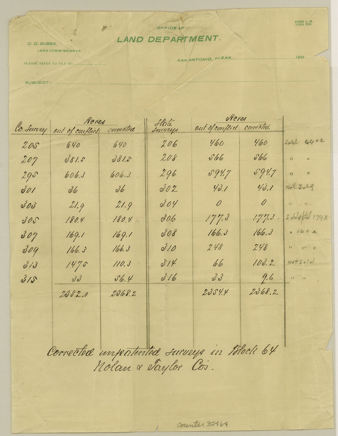
Nolan County Sketch File 8
[List of corrected, unpatented surveys in Block 64]
-
Map/Doc
32464
-
Collection
General Map Collection
-
Counties
Nolan Taylor
-
Subjects
Surveying Sketch File
-
Height x Width
11.3 x 8.8 inches
28.7 x 22.4 cm
-
Medium
paper, manuscript
Part of: General Map Collection
Edwards County Sketch File 34

Print $20.00
- Digital $50.00
Edwards County Sketch File 34
Size 16.8 x 19.0 inches
Map/Doc 11434
El Paso County Rolled Sketch 52

Print $20.00
- Digital $50.00
El Paso County Rolled Sketch 52
1929
Size 18.4 x 24.3 inches
Map/Doc 5839
Van Zandt County Working Sketch 6a

Print $40.00
- Digital $50.00
Van Zandt County Working Sketch 6a
1941
Size 57.6 x 30.1 inches
Map/Doc 72255
Robertson County Rolled Sketch 2

Print $43.00
- Digital $50.00
Robertson County Rolled Sketch 2
1974
Size 9.6 x 15.1 inches
Map/Doc 48861
Harris County Sketch File 59a

Print $20.00
- Digital $50.00
Harris County Sketch File 59a
Size 25.1 x 40.1 inches
Map/Doc 10479
Padre Island National Seashore, Texas - Dependent Resurvey

Print $4.00
- Digital $50.00
Padre Island National Seashore, Texas - Dependent Resurvey
2001
Size 18.4 x 24.0 inches
Map/Doc 60549
Travis County

Print $40.00
- Digital $50.00
Travis County
1936
Size 47.0 x 53.7 inches
Map/Doc 73305
Map of Mason County

Print $20.00
- Digital $50.00
Map of Mason County
1879
Size 22.9 x 18.8 inches
Map/Doc 4593
Calhoun County NRC Article 33.136 Sketch 1

Print $42.00
- Digital $50.00
Calhoun County NRC Article 33.136 Sketch 1
2000
Size 16.8 x 21.7 inches
Map/Doc 61556
Maps of Gulf Intracoastal Waterway, Texas - Sabine River to the Rio Grande and connecting waterways including ship channels

Print $20.00
- Digital $50.00
Maps of Gulf Intracoastal Waterway, Texas - Sabine River to the Rio Grande and connecting waterways including ship channels
1966
Size 14.6 x 22.3 inches
Map/Doc 61930
Lamb County Sketch File 14

Print $6.00
- Digital $50.00
Lamb County Sketch File 14
1914
Size 7.3 x 8.7 inches
Map/Doc 29374
Brown County Working Sketch 2

Print $20.00
- Digital $50.00
Brown County Working Sketch 2
1919
Size 17.0 x 17.5 inches
Map/Doc 67767
You may also like
Map of Chicago, Rock Island & Texas Railway

Print $20.00
- Digital $50.00
Map of Chicago, Rock Island & Texas Railway
1892
Size 22.4 x 44.0 inches
Map/Doc 64443
Montague County Working Sketch 11

Print $20.00
- Digital $50.00
Montague County Working Sketch 11
1936
Size 33.8 x 21.3 inches
Map/Doc 71077
South Part of Brewster Co.

Print $20.00
- Digital $50.00
South Part of Brewster Co.
1955
Size 47.3 x 39.6 inches
Map/Doc 77221
El Paso County Working Sketch 44

Print $20.00
- Digital $50.00
El Paso County Working Sketch 44
1992
Size 25.6 x 25.4 inches
Map/Doc 69066
Loving County Sketch File 1

Print $4.00
- Digital $50.00
Loving County Sketch File 1
1931
Size 11.2 x 8.6 inches
Map/Doc 30407
Eastland County Working Sketch 21

Print $20.00
- Digital $50.00
Eastland County Working Sketch 21
1920
Size 15.4 x 22.7 inches
Map/Doc 68802
Culberson County Working Sketch 87

Print $20.00
- Digital $50.00
Culberson County Working Sketch 87
1981
Size 26.9 x 37.1 inches
Map/Doc 68541
Leon County Rolled Sketch 3

Print $20.00
- Digital $50.00
Leon County Rolled Sketch 3
Size 16.8 x 22.5 inches
Map/Doc 6595
Harris County Sketch File 97

Print $28.00
- Digital $50.00
Harris County Sketch File 97
1917
Size 14.3 x 8.9 inches
Map/Doc 25641
General Highway Map, Kimble County, Texas

Print $20.00
General Highway Map, Kimble County, Texas
1961
Size 24.6 x 18.2 inches
Map/Doc 79553
Lavaca County Working Sketch 13

Print $20.00
- Digital $50.00
Lavaca County Working Sketch 13
1958
Size 23.5 x 29.1 inches
Map/Doc 70366
[Sketch for Mineral Application 13440]
![2799, [Sketch for Mineral Application 13440], General Map Collection](https://historictexasmaps.com/wmedia_w700/maps/2799-1.tif.jpg)
Print $20.00
- Digital $50.00
[Sketch for Mineral Application 13440]
1925
Size 24.3 x 54.0 inches
Map/Doc 2799