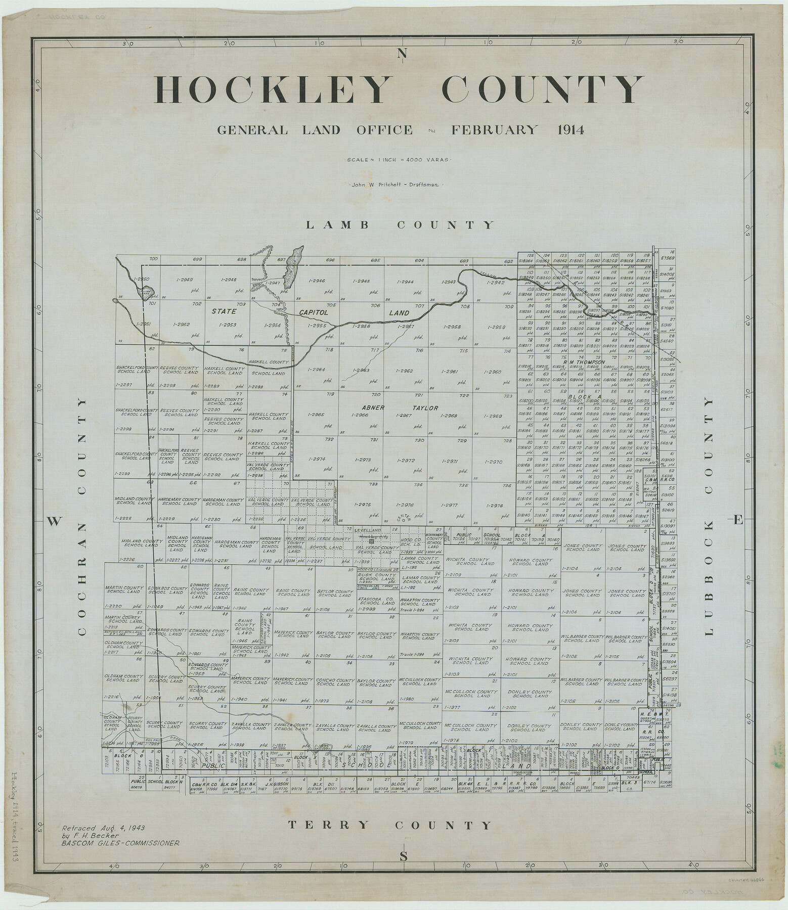
Hockley County
-
Map/Doc
66866
-
Collection
General Map Collection
-
Object Dates
1914 (Creation Date)
-
People and Organizations
Texas General Land Office (Publisher)
Bascom Giles (GLO Commissioner)
John W. Pritchett (Compiler)
John W. Pritchett (Draftsman)
-
Counties
Hockley
-
Subjects
County
-
Height x Width
25.8 x 22.4 inches
65.5 x 56.9 cm
-
Comments
Retraced August 4, 1943 by F. H. Becker.
Part of: General Map Collection
Cass County Sketch File 2

Print $4.00
- Digital $50.00
Cass County Sketch File 2
1849
Size 12.4 x 7.7 inches
Map/Doc 17394
Waller County Working Sketch 6

Print $20.00
- Digital $50.00
Waller County Working Sketch 6
1988
Size 31.1 x 20.0 inches
Map/Doc 72305
Bandera County Working Sketch 5

Print $3.00
- Digital $50.00
Bandera County Working Sketch 5
1915
Size 12.0 x 9.0 inches
Map/Doc 67598
Somervell County Sketch File 7

Print $8.00
- Digital $50.00
Somervell County Sketch File 7
1987
Size 11.4 x 8.9 inches
Map/Doc 36850
Flight Mission No. DAG-23K, Frame 152, Matagorda County

Print $20.00
- Digital $50.00
Flight Mission No. DAG-23K, Frame 152, Matagorda County
1953
Size 15.9 x 15.9 inches
Map/Doc 86500
[Cotton Belt, St. Louis Southwestern Railway of Texas, Alignment through Smith County]
![64383, [Cotton Belt, St. Louis Southwestern Railway of Texas, Alignment through Smith County], General Map Collection](https://historictexasmaps.com/wmedia_w700/maps/64383.tif.jpg)
Print $20.00
- Digital $50.00
[Cotton Belt, St. Louis Southwestern Railway of Texas, Alignment through Smith County]
1903
Size 21.5 x 29.4 inches
Map/Doc 64383
Presidio County Working Sketch 134

Print $40.00
- Digital $50.00
Presidio County Working Sketch 134
1989
Size 37.0 x 55.6 inches
Map/Doc 71812
Denton County Sketch File 33a

Print $4.00
- Digital $50.00
Denton County Sketch File 33a
Size 8.0 x 13.1 inches
Map/Doc 20762
A New Map of North America with the West India Islands divided according to the preliminary Articles of Peace, signed at Versailles, 20 Jan. 1783

Print $40.00
- Digital $50.00
A New Map of North America with the West India Islands divided according to the preliminary Articles of Peace, signed at Versailles, 20 Jan. 1783
1794
Size 42.1 x 48.4 inches
Map/Doc 93734
Duval County Working Sketch 51

Print $20.00
- Digital $50.00
Duval County Working Sketch 51
1986
Size 27.3 x 35.3 inches
Map/Doc 68775
Flight Mission No. BRE-2P, Frame 135, Nueces County

Print $20.00
- Digital $50.00
Flight Mission No. BRE-2P, Frame 135, Nueces County
1956
Size 18.5 x 22.7 inches
Map/Doc 86808
Railroad Track Map, H&TCRRCo., Falls County, Texas

Print $4.00
- Digital $50.00
Railroad Track Map, H&TCRRCo., Falls County, Texas
1918
Size 11.7 x 18.5 inches
Map/Doc 62842
You may also like
[Surveys in Austin's Colony along Buffalo Bayou and the San Jacinto River]
![207, [Surveys in Austin's Colony along Buffalo Bayou and the San Jacinto River], General Map Collection](https://historictexasmaps.com/wmedia_w700/maps/207.tif.jpg)
Print $20.00
- Digital $50.00
[Surveys in Austin's Colony along Buffalo Bayou and the San Jacinto River]
1824
Size 22.3 x 14.3 inches
Map/Doc 207
Uvalde County Working Sketch 53

Print $20.00
- Digital $50.00
Uvalde County Working Sketch 53
1982
Size 30.4 x 43.0 inches
Map/Doc 72123
Randall County Sketch File 1

Print $50.00
- Digital $50.00
Randall County Sketch File 1
1912
Size 24.6 x 35.6 inches
Map/Doc 12205
Brewster County Sketch File FN-34

Print $40.00
- Digital $50.00
Brewster County Sketch File FN-34
1943
Size 23.1 x 27.1 inches
Map/Doc 10984
Portion of States Submerged Area in Matagorda Bay

Print $20.00
- Digital $50.00
Portion of States Submerged Area in Matagorda Bay
1923
Size 12.7 x 13.5 inches
Map/Doc 2956
Mitchell County Working Sketch 5

Print $40.00
- Digital $50.00
Mitchell County Working Sketch 5
1956
Size 60.4 x 28.2 inches
Map/Doc 71062
Map of Caldwell County

Print $20.00
- Digital $50.00
Map of Caldwell County
1871
Size 16.9 x 19.9 inches
Map/Doc 4591
City of Austin, Texas and Suburban Areas

Print $40.00
- Digital $50.00
City of Austin, Texas and Suburban Areas
1964
Size 48.3 x 34.4 inches
Map/Doc 73563
La Salle County Working Sketch 34

Print $20.00
- Digital $50.00
La Salle County Working Sketch 34
1956
Size 18.8 x 26.2 inches
Map/Doc 70335

