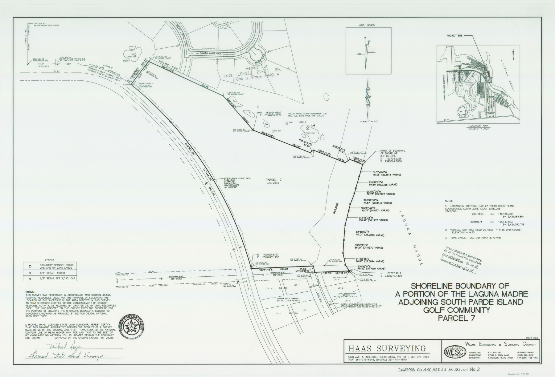
Cameron County NRC Article 33.136 Sketch 2
Shoreline Boundary of a Portion of the Laguna Madre Adjoining South Padre Island Golf Community Parcel 7
-
Map/Doc
77040
-
Collection
General Map Collection
-
Object Dates
2002/8/16 (Creation Date)
2007/9/27 (File Date)
-
People and Organizations
Haas Surveying (Publisher)
Haas Surveying (Printer)
Michael Haas (Surveyor/Engineer)
-
Counties
Cameron
-
Subjects
Surveying CBS
-
Height x Width
24.4 x 35.9 inches
62.0 x 91.2 cm
-
Medium
mylar, print
-
Comments
Survey located about 17 miles North 41 degrees East of Brownvilles, Texas.
Part of: General Map Collection
Navasota River, Long Bridge Crossing Sheet

Print $20.00
- Digital $50.00
Navasota River, Long Bridge Crossing Sheet
1934
Size 43.1 x 36.6 inches
Map/Doc 65073

Baylor County Sketch File 18

Print $6.00
- Digital $50.00
Baylor County Sketch File 18
1887
Size 11.1 x 13.2 inches
Map/Doc 14191
Hardeman County Sketch File 31

Print $4.00
- Digital $50.00
Hardeman County Sketch File 31
Size 14.5 x 9.0 inches
Map/Doc 25066
Coleman County Sketch File 50

Print $4.00
- Digital $50.00
Coleman County Sketch File 50
Size 12.6 x 8.2 inches
Map/Doc 18853
Chart of soundings through the different channels in Aransas and Matagorda Bays as taken in 1855 by Capt. R. B. Marey, U. S. A. [Inset: Harbour of Lamar and Live-Oak Pt.]
![72977, Chart of soundings through the different channels in Aransas and Matagorda Bays as taken in 1855 by Capt. R. B. Marey, U. S. A. [Inset: Harbour of Lamar and Live-Oak Pt.], General Map Collection](https://historictexasmaps.com/wmedia_w700/maps/72977.tif.jpg)
Print $20.00
- Digital $50.00
Chart of soundings through the different channels in Aransas and Matagorda Bays as taken in 1855 by Capt. R. B. Marey, U. S. A. [Inset: Harbour of Lamar and Live-Oak Pt.]
Size 28.1 x 18.2 inches
Map/Doc 72977
Presidio County Rolled Sketch 39

Print $20.00
- Digital $50.00
Presidio County Rolled Sketch 39
Size 16.0 x 22.0 inches
Map/Doc 7336
[Surveys in the Bexar District along the Cibolo Creek]
![3168, [Surveys in the Bexar District along the Cibolo Creek], General Map Collection](https://historictexasmaps.com/wmedia_w700/maps/3168.tif.jpg)
Print $2.00
- Digital $50.00
[Surveys in the Bexar District along the Cibolo Creek]
1846
Size 5.1 x 6.7 inches
Map/Doc 3168
Howard County Boundary File 3a

Print $62.00
- Digital $50.00
Howard County Boundary File 3a
Size 3.9 x 8.7 inches
Map/Doc 55155
Frio County Rolled Sketch 15

Print $20.00
- Digital $50.00
Frio County Rolled Sketch 15
1949
Size 26.1 x 39.0 inches
Map/Doc 5922
Atascosa County Working Sketch 2

Print $20.00
- Digital $50.00
Atascosa County Working Sketch 2
1910
Size 23.5 x 33.2 inches
Map/Doc 67197

You may also like
Flight Mission No. DQO-8K, Frame 72, Galveston County

Print $20.00
- Digital $50.00
Flight Mission No. DQO-8K, Frame 72, Galveston County
1952
Size 18.7 x 22.4 inches
Map/Doc 85176
Eastern Heights Addition to City of Lubbock, Texas a Subdivision of SW/4 of SW/4, Section 5, Block O, E. Hayes Sieber, Owner

Print $20.00
- Digital $50.00
Eastern Heights Addition to City of Lubbock, Texas a Subdivision of SW/4 of SW/4, Section 5, Block O, E. Hayes Sieber, Owner
1952
Size 18.0 x 23.1 inches
Map/Doc 92783
Cooke County Working Sketch 2

Print $20.00
- Digital $50.00
Cooke County Working Sketch 2
1925
Size 22.2 x 10.9 inches
Map/Doc 68239
United States - Gulf Coast - Galveston to Rio Grande

Print $20.00
- Digital $50.00
United States - Gulf Coast - Galveston to Rio Grande
Size 27.9 x 18.3 inches
Map/Doc 72739
Brooks County Working Sketch 3

Print $20.00
- Digital $50.00
Brooks County Working Sketch 3
Size 16.2 x 21.3 inches
Map/Doc 67787
Reagan County Sketch File 26

Print $20.00
- Digital $50.00
Reagan County Sketch File 26
1948
Size 16.9 x 28.7 inches
Map/Doc 12223
Martin County Sketch File 10

Print $50.00
- Digital $50.00
Martin County Sketch File 10
Size 11.2 x 8.8 inches
Map/Doc 30644
Harris County Sketch File 81

Print $20.00
- Digital $50.00
Harris County Sketch File 81
Size 25.5 x 16.5 inches
Map/Doc 11669
Terry County Rolled Sketch 5

Print $40.00
- Digital $50.00
Terry County Rolled Sketch 5
Size 56.8 x 38.1 inches
Map/Doc 9995
Fractional Township No. 8 South Range No. 21 East of the Indian Meridian, Indian Territory

Print $20.00
- Digital $50.00
Fractional Township No. 8 South Range No. 21 East of the Indian Meridian, Indian Territory
1897
Size 19.2 x 24.2 inches
Map/Doc 75238
Wharton County Sketch File 11

Print $4.00
- Digital $50.00
Wharton County Sketch File 11
1891
Size 9.1 x 12.3 inches
Map/Doc 39933
Terrell County Working Sketch 76

Print $20.00
- Digital $50.00
Terrell County Working Sketch 76
1982
Size 31.8 x 20.1 inches
Map/Doc 69597