Brazoria County NRC Article 33.136 Sketch 25
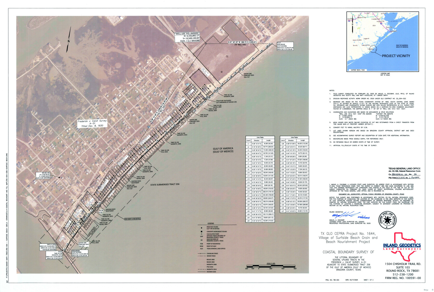
Coastal Boundary Survey of the littoral boundary of several upland tracts in the Frederick J. Calvit survey, A-51 adjacent to State Submerged Tract 356 of the Gulf of America (Gulf of Mexico)
-
Map/Doc
97440
-
Collection
General Map Collection
-
Object Dates
4/17/2025 (Creation Date)
6/3/2025 (File Date)
-
People and Organizations
Miguel A. Escobar (Surveyor/Engineer)
-
Counties
Brazoria
-
Subjects
Surveying CBS
-
Comments
Project: Surfside Beach Groin & Beach Nourishment - Escobar
Project No.: CEPRA # 1644
Part of: General Map Collection
Flight Mission No. DAG-19K, Frame 59, Matagorda County

Print $20.00
- Digital $50.00
Flight Mission No. DAG-19K, Frame 59, Matagorda County
1952
Size 18.6 x 22.2 inches
Map/Doc 86386
Liberty County Sketch File 48

Print $6.00
- Digital $50.00
Liberty County Sketch File 48
1879
Size 12.2 x 8.3 inches
Map/Doc 30010
Flight Mission No. BRE-2P, Frame 47, Nueces County

Print $20.00
- Digital $50.00
Flight Mission No. BRE-2P, Frame 47, Nueces County
1956
Size 18.6 x 22.6 inches
Map/Doc 86749
Kenedy County

Print $20.00
- Digital $50.00
Kenedy County
1913
Size 41.0 x 31.8 inches
Map/Doc 66888
Travis County Appraisal District Plat Map 2_2011

Print $20.00
- Digital $50.00
Travis County Appraisal District Plat Map 2_2011
Size 21.4 x 26.4 inches
Map/Doc 94211
Bowie County Working Sketch 16

Print $20.00
- Digital $50.00
Bowie County Working Sketch 16
1961
Size 17.8 x 17.2 inches
Map/Doc 67420
Montgomery County Sketch File 21

Print $8.00
- Digital $50.00
Montgomery County Sketch File 21
1934
Size 9.0 x 13.2 inches
Map/Doc 31856
Angelina County Working Sketch 38

Print $20.00
- Digital $50.00
Angelina County Working Sketch 38
1958
Size 26.4 x 33.0 inches
Map/Doc 67121
Colorado County Working Sketch 14

Print $20.00
- Digital $50.00
Colorado County Working Sketch 14
1944
Size 30.8 x 21.6 inches
Map/Doc 68114
Harris County State Real Property Sketch 2

Print $32.00
- Digital $50.00
Harris County State Real Property Sketch 2
1999
Size 30.2 x 42.4 inches
Map/Doc 61702
Brewster County Sketch File 39

Print $4.00
- Digital $50.00
Brewster County Sketch File 39
Size 12.8 x 8.9 inches
Map/Doc 16300
Armstrong County Sketch File B

Print $26.00
- Digital $50.00
Armstrong County Sketch File B
1903
Size 14.2 x 8.5 inches
Map/Doc 13669
You may also like
Hicks, Station Map-Tracks & Structures Lands, San Antonio & Aransas Pass Railway Co.

Print $4.00
- Digital $50.00
Hicks, Station Map-Tracks & Structures Lands, San Antonio & Aransas Pass Railway Co.
1919
Size 11.7 x 18.6 inches
Map/Doc 62568
Boundary Between U.S. - Mexico, 1853

Print $20.00
- Digital $50.00
Boundary Between U.S. - Mexico, 1853
1954
Size 24.3 x 18.4 inches
Map/Doc 65416
Flight Mission No. CZW-1R, Frame 165, Hardeman County

Print $20.00
- Digital $50.00
Flight Mission No. CZW-1R, Frame 165, Hardeman County
1956
Size 18.7 x 22.4 inches
Map/Doc 85236
Map of Milam County

Print $40.00
- Digital $50.00
Map of Milam County
1839
Size 54.5 x 45.9 inches
Map/Doc 3881
Oldham County Rolled Sketch 5

Print $20.00
- Digital $50.00
Oldham County Rolled Sketch 5
1903
Size 29.7 x 36.6 inches
Map/Doc 9641
Texas-Oklahoma (Indian Territory) Montague Quadrangle

Print $20.00
- Digital $50.00
Texas-Oklahoma (Indian Territory) Montague Quadrangle
1905
Size 20.4 x 17.0 inches
Map/Doc 75106
Floyd County Boundary File 2b

Print $40.00
- Digital $50.00
Floyd County Boundary File 2b
Size 38.9 x 20.1 inches
Map/Doc 53490
James Heights, an addition to the City of Lubbock - tracts 4, 5, 6, 7, 8, 9, 10, 11, 12, 13 in Block 7, and tracts 4, 5, 6, 7, 8, 9, 10, 11, 12, 13 in Block 8 of the Clutter Addition

Print $3.00
- Digital $50.00
James Heights, an addition to the City of Lubbock - tracts 4, 5, 6, 7, 8, 9, 10, 11, 12, 13 in Block 7, and tracts 4, 5, 6, 7, 8, 9, 10, 11, 12, 13 in Block 8 of the Clutter Addition
1949
Size 10.1 x 11.4 inches
Map/Doc 92704
Henderson County

Print $40.00
- Digital $50.00
Henderson County
1897
Size 30.2 x 60.8 inches
Map/Doc 66859
McMullen County Sketch File 45

Print $10.00
- Digital $50.00
McMullen County Sketch File 45
1943
Size 14.2 x 8.9 inches
Map/Doc 31429
Reeves County Working Sketch 61

Print $20.00
- Digital $50.00
Reeves County Working Sketch 61
1982
Size 32.1 x 31.4 inches
Map/Doc 63504
Brewster County Rolled Sketch 26

Print $20.00
- Digital $50.00
Brewster County Rolled Sketch 26
Size 15.8 x 32.0 inches
Map/Doc 5214