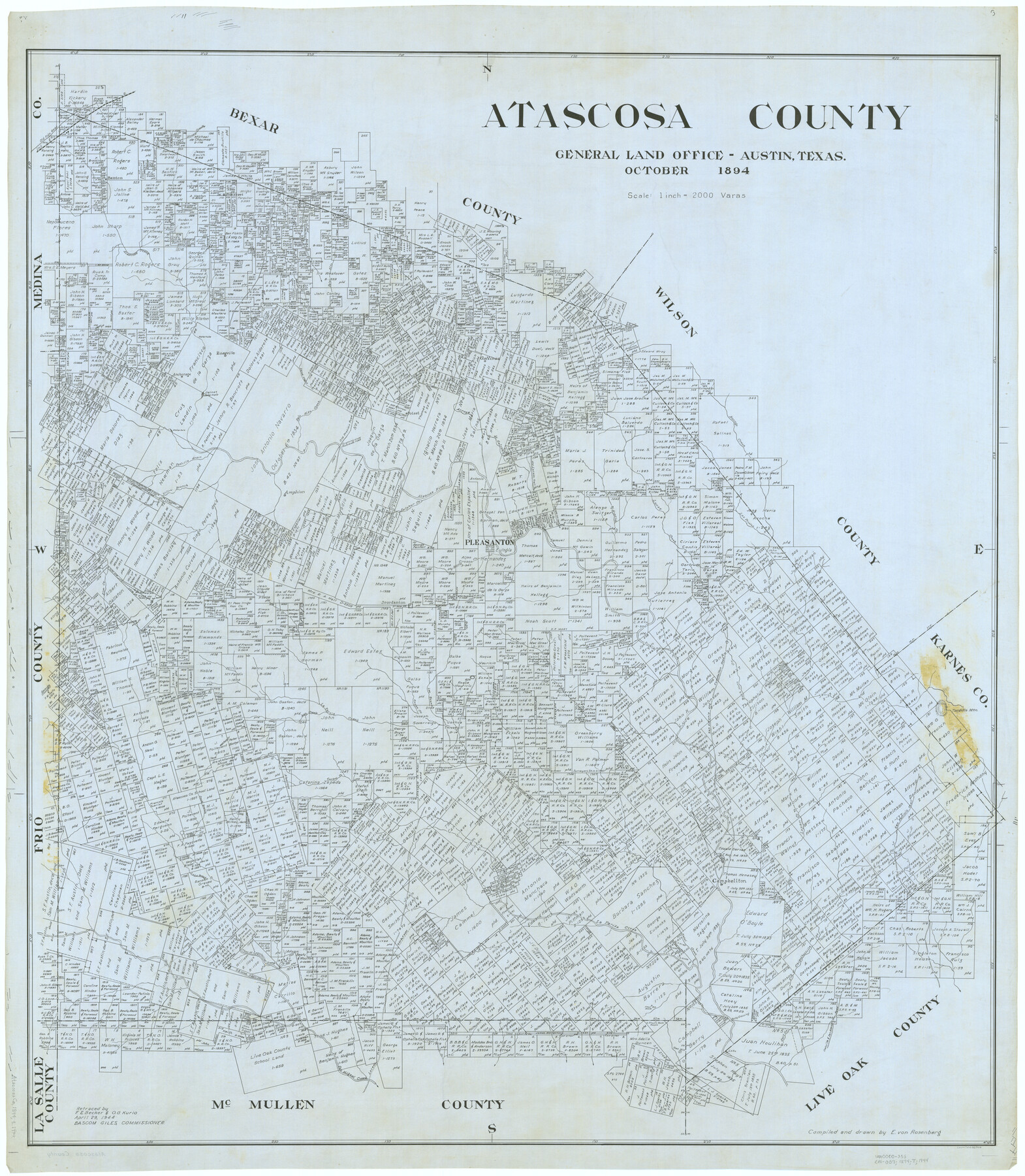
Atascosa County
-
Map/Doc
66706
-
Collection
General Map Collection
-
Object Dates
1894 (Creation Date)
-
People and Organizations
Texas General Land Office (Publisher)
E. von Rosenberg (Compiler)
Bascom Giles (GLO Commissioner)
E. von Rosenberg (Draftsman)
-
Counties
Atascosa
-
Subjects
County
-
Height x Width
50.5 x 44.1 inches
128.3 x 112.0 cm
-
Comments
Retraced April 29, 1944 by F. E. Becker and O. G. Kurio.
Part of: General Map Collection
[Sketch for Mineral Application 17237 / Mineral File 11855 - Neches River, Joe A. Sanders]
![65686, [Sketch for Mineral Application 17237 / Mineral File 11855 - Neches River, Joe A. Sanders], General Map Collection](https://historictexasmaps.com/wmedia_w700/maps/65686.tif.jpg)
Print $40.00
- Digital $50.00
[Sketch for Mineral Application 17237 / Mineral File 11855 - Neches River, Joe A. Sanders]
1927
Size 78.2 x 30.7 inches
Map/Doc 65686
Burnet County Sketch File 19

Print $4.00
- Digital $50.00
Burnet County Sketch File 19
1859
Size 11.6 x 8.2 inches
Map/Doc 16710
Blanco County Sketch File 10

Print $4.00
- Digital $50.00
Blanco County Sketch File 10
1853
Size 14.6 x 8.2 inches
Map/Doc 14588
Stonewall County

Print $20.00
- Digital $50.00
Stonewall County
1888
Size 17.8 x 24.6 inches
Map/Doc 89055
Clay County Sketch File 41

Print $6.00
- Digital $50.00
Clay County Sketch File 41
1949
Size 14.2 x 8.6 inches
Map/Doc 18482
[Surveys near Hondo Creek]
![229, [Surveys near Hondo Creek], General Map Collection](https://historictexasmaps.com/wmedia_w700/maps/229.tif.jpg)
Print $2.00
- Digital $50.00
[Surveys near Hondo Creek]
1846
Size 11.6 x 7.2 inches
Map/Doc 229
Map of Red River County

Print $20.00
- Digital $50.00
Map of Red River County
1856
Size 22.2 x 18.4 inches
Map/Doc 3981
Flight Mission No. CON-2R, Frame 114, Stonewall County

Print $20.00
- Digital $50.00
Flight Mission No. CON-2R, Frame 114, Stonewall County
1957
Size 18.3 x 22.0 inches
Map/Doc 86989
Crockett County Working Sketch 21

Print $20.00
- Digital $50.00
Crockett County Working Sketch 21
1920
Size 18.5 x 24.8 inches
Map/Doc 68354
Dickens County Sketch File 2a

Print $4.00
- Digital $50.00
Dickens County Sketch File 2a
1884
Size 14.2 x 8.9 inches
Map/Doc 20950
Presidio County Working Sketch 9a

Print $20.00
- Digital $50.00
Presidio County Working Sketch 9a
1933
Size 17.3 x 12.2 inches
Map/Doc 71684
Nueces County Rolled Sketch 127

Print $20.00
- Digital $50.00
Nueces County Rolled Sketch 127
1998
Size 24.1 x 36.4 inches
Map/Doc 7162
You may also like
Grimes County Working Sketch 4

Print $20.00
- Digital $50.00
Grimes County Working Sketch 4
1948
Size 20.0 x 24.5 inches
Map/Doc 63295
Hockley County Sketch File 15

Print $6.00
- Digital $50.00
Hockley County Sketch File 15
1912
Size 11.4 x 8.9 inches
Map/Doc 26550
Kimble County Sketch File 9

Print $22.00
- Digital $50.00
Kimble County Sketch File 9
1871
Size 8.2 x 14.1 inches
Map/Doc 28927
San Patricio County Rolled Sketch 31

Print $20.00
- Digital $50.00
San Patricio County Rolled Sketch 31
1941
Size 43.1 x 42.6 inches
Map/Doc 9898
Pecos County Sketch File 68

Print $6.00
- Digital $50.00
Pecos County Sketch File 68
1920
Size 14.4 x 8.8 inches
Map/Doc 33866
Flight Mission No. CGI-3N, Frame 44, Cameron County

Print $20.00
- Digital $50.00
Flight Mission No. CGI-3N, Frame 44, Cameron County
1954
Size 18.9 x 22.5 inches
Map/Doc 84550
Mason County Working Sketch 13

Print $20.00
- Digital $50.00
Mason County Working Sketch 13
1954
Size 20.0 x 29.9 inches
Map/Doc 70849
Leon County Working Sketch 58

Print $20.00
- Digital $50.00
Leon County Working Sketch 58
1986
Size 27.7 x 43.3 inches
Map/Doc 70458
Red River County Working Sketch 51

Print $20.00
- Digital $50.00
Red River County Working Sketch 51
1970
Size 31.2 x 28.5 inches
Map/Doc 72034
Limestone County Sketch File 1

Print $4.00
- Digital $50.00
Limestone County Sketch File 1
Size 9.8 x 8.1 inches
Map/Doc 30155
Mills County Working Sketch 7

Print $20.00
- Digital $50.00
Mills County Working Sketch 7
1914
Size 12.8 x 13.0 inches
Map/Doc 71037
A Map of Part of Panola County [Judicial District]
![328, A Map of Part of Panola County [Judicial District], General Map Collection](https://historictexasmaps.com/wmedia_w700/maps/328.tif.jpg)
Print $20.00
- Digital $50.00
A Map of Part of Panola County [Judicial District]
1841
Size 18.3 x 15.4 inches
Map/Doc 328