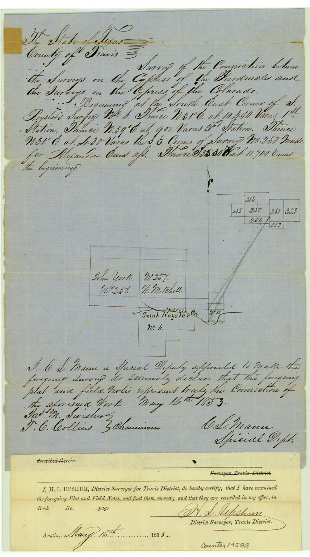
Blanco County Sketch File 10
[Survey of the connection between surveys on the Cypress Creek of the Pedernales River and surveys on the Cypress Creek of the Colorado River]
-
Map/Doc
14588
-
Collection
General Map Collection
-
Object Dates
1853/5/14 (Creation Date)
-
People and Organizations
C.S. Mann (Surveyor/Engineer)
Jas. M. Swisher (Chainman/Field Personnel)
T.C. Collins (Chainman/Field Personnel)
-
Counties
Blanco Burnet
-
Subjects
Surveying Sketch File
-
Height x Width
14.6 x 8.2 inches
37.1 x 20.8 cm
-
Medium
paper, manuscript
-
Features
Cypress Creek Branch of the Pedernales River
Cypress Creek Branch of the Colorado River
Cypress Creek
Part of: General Map Collection
Laguna Madre, Register No. 1477B

Print $40.00
- Digital $50.00
Laguna Madre, Register No. 1477B
1880
Size 33.4 x 56.6 inches
Map/Doc 73607

Jefferson County NRC Article 33.136 Sketch 1

Print $20.00
- Digital $50.00
Jefferson County NRC Article 33.136 Sketch 1
2002
Size 24.0 x 36.1 inches
Map/Doc 61601
Cameron County Rolled Sketch 28B

Print $40.00
- Digital $50.00
Cameron County Rolled Sketch 28B
1986
Size 36.9 x 48.3 inches
Map/Doc 8577
Flight Mission No. DCL-7C, Frame 122, Kenedy County

Print $20.00
- Digital $50.00
Flight Mission No. DCL-7C, Frame 122, Kenedy County
1943
Size 18.6 x 22.4 inches
Map/Doc 86087
Red River County Sketch File 10

Print $15.00
- Digital $50.00
Red River County Sketch File 10
1863
Size 9.1 x 7.4 inches
Map/Doc 35121
Duval County Rolled Sketch 20

Print $20.00
- Digital $50.00
Duval County Rolled Sketch 20
Size 33.2 x 42.0 inches
Map/Doc 8811
La Salle County Rolled Sketch 15

Print $20.00
- Digital $50.00
La Salle County Rolled Sketch 15
Size 22.0 x 32.4 inches
Map/Doc 6579
McLennan County Boundary File 2a

Print $10.00
- Digital $50.00
McLennan County Boundary File 2a
Size 8.7 x 5.7 inches
Map/Doc 56958
Map of Surveys Made for the T&PRRCo in Tom Green & Martin Counties, Blocks 40, 41, 42, 43, 44, 45 & 46, Reserve West of the Colorado

Print $20.00
- Digital $50.00
Map of Surveys Made for the T&PRRCo in Tom Green & Martin Counties, Blocks 40, 41, 42, 43, 44, 45 & 46, Reserve West of the Colorado
1876
Size 42.3 x 46.0 inches
Map/Doc 2227
Pecos County Working Sketch 123

Print $20.00
- Digital $50.00
Pecos County Working Sketch 123
1973
Size 42.4 x 24.2 inches
Map/Doc 71596
Lynn County Rolled Sketch 12

Print $20.00
- Digital $50.00
Lynn County Rolled Sketch 12
1956
Size 35.0 x 24.5 inches
Map/Doc 6648
You may also like
Blanco County Working Sketch 41

Print $20.00
- Digital $50.00
Blanco County Working Sketch 41
1986
Size 28.4 x 25.2 inches
Map/Doc 67401
San Jacinto County Rolled Sketch 4
Print $20.00
- Digital $50.00
San Jacinto County Rolled Sketch 4
Size 24.3 x 32.6 inches
Map/Doc 7557
Map of Trinity Co.

Print $20.00
- Digital $50.00
Map of Trinity Co.
1896
Size 40.7 x 39.1 inches
Map/Doc 63079
Wilda Stewart Farm, Crosby County, Texas

Print $20.00
- Digital $50.00
Wilda Stewart Farm, Crosby County, Texas
1949
Size 20.5 x 20.4 inches
Map/Doc 92599
Deaf Smith County, Texas / [Sec. 144, Blk. K-5]
![92037, Deaf Smith County, Texas / [Sec. 144, Blk. K-5], Twichell Survey Records](https://historictexasmaps.com/wmedia_w700/maps/92037-1.tif.jpg)
Print $20.00
- Digital $50.00
Deaf Smith County, Texas / [Sec. 144, Blk. K-5]
Size 25.6 x 19.6 inches
Map/Doc 92037
East Part of Brewster Co.

Print $40.00
- Digital $50.00
East Part of Brewster Co.
1952
Size 48.5 x 30.7 inches
Map/Doc 77219
Bailey County Working Sketch 4

Print $20.00
- Digital $50.00
Bailey County Working Sketch 4
1937
Size 27.0 x 32.0 inches
Map/Doc 67591
Mason County Rolled Sketch 1

Print $20.00
- Digital $50.00
Mason County Rolled Sketch 1
1940
Size 21.2 x 24.9 inches
Map/Doc 6674
Flight Mission No. DAG-23K, Frame 59, Matagorda County

Print $20.00
- Digital $50.00
Flight Mission No. DAG-23K, Frame 59, Matagorda County
1953
Size 18.5 x 22.3 inches
Map/Doc 86486
[Sketch for Mineral Application 11108 - Greens Bayou]
![2786, [Sketch for Mineral Application 11108 - Greens Bayou], General Map Collection](https://historictexasmaps.com/wmedia_w700/maps/2786-1.tif.jpg)
Print $20.00
- Digital $50.00
[Sketch for Mineral Application 11108 - Greens Bayou]
1922
Size 46.0 x 21.0 inches
Map/Doc 2786
Dickens County
Print $20.00
- Digital $50.00
Dickens County
1891
Size 27.7 x 21.9 inches
Map/Doc 66804
Flight Mission No. CLL-1N, Frame 86, Willacy County

Print $20.00
- Digital $50.00
Flight Mission No. CLL-1N, Frame 86, Willacy County
1954
Size 18.4 x 22.1 inches
Map/Doc 87032