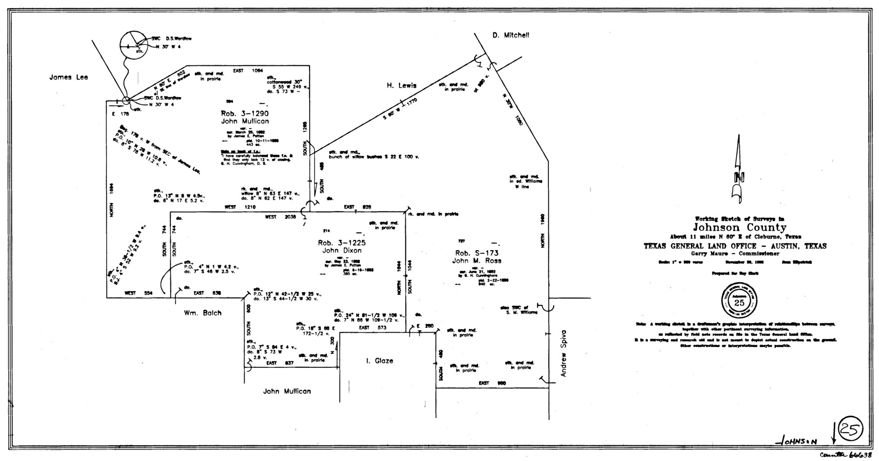
Johnson County Working Sketch 25
-
Map/Doc
66638
-
Collection
General Map Collection
-
Object Dates
11/28/1998 (Creation Date)
-
People and Organizations
Joan Kilpatrick (Draftsman)
-
Counties
Johnson
-
Subjects
Surveying Working Sketch
-
Height x Width
13.3 x 25.4 inches
33.8 x 64.5 cm
-
Scale
1" = 300 varas
Part of: General Map Collection
Dallam County Sketch File 1

Print $22.00
- Digital $50.00
Dallam County Sketch File 1
1885
Size 29.5 x 27.1 inches
Map/Doc 11277
Kent County Working Sketch 14

Print $20.00
- Digital $50.00
Kent County Working Sketch 14
1965
Size 28.2 x 35.4 inches
Map/Doc 70021
Wilson County Working Sketch 9

Print $20.00
- Digital $50.00
Wilson County Working Sketch 9
1979
Size 31.6 x 33.0 inches
Map/Doc 72589
Lee County Sketch File 10

Print $10.00
- Digital $50.00
Lee County Sketch File 10
2009
Size 11.0 x 8.5 inches
Map/Doc 89289
Edwards County Sketch File ABC

Print $12.00
- Digital $50.00
Edwards County Sketch File ABC
1913
Size 14.5 x 9.1 inches
Map/Doc 21662
Harris County Sketch File 33a

Print $20.00
- Digital $50.00
Harris County Sketch File 33a
Size 34.1 x 30.0 inches
Map/Doc 10478
Refugio County Boundary File 3

Print $4.00
- Digital $50.00
Refugio County Boundary File 3
Size 14.0 x 8.7 inches
Map/Doc 58244
Map and Profile of Georgetown Railroad

Print $20.00
- Digital $50.00
Map and Profile of Georgetown Railroad
1879
Size 18.9 x 41.5 inches
Map/Doc 64453
A Topographical Map of the City of Austin

Print $20.00
- Digital $50.00
A Topographical Map of the City of Austin
1872
Size 21.0 x 14.7 inches
Map/Doc 4821
Trinity County Sketch File 38

Print $8.00
- Digital $50.00
Trinity County Sketch File 38
1948
Size 14.5 x 8.9 inches
Map/Doc 38593
Edwards County Sketch File 12c

Print $20.00
- Digital $50.00
Edwards County Sketch File 12c
Size 23.0 x 26.8 inches
Map/Doc 11425
Brewster County Rolled Sketch 60

Print $20.00
- Digital $50.00
Brewster County Rolled Sketch 60
Size 24.8 x 36.5 inches
Map/Doc 61783
You may also like
General Highway Map, Harris County, Texas

Print $20.00
General Highway Map, Harris County, Texas
1961
Size 24.7 x 18.0 inches
Map/Doc 79501
Rio Grande, Penitas Sheet

Print $20.00
- Digital $50.00
Rio Grande, Penitas Sheet
1937
Size 40.2 x 42.9 inches
Map/Doc 65119
Texas, Matagorda Bay, Vicinity of Carancahua Bay

Print $40.00
- Digital $50.00
Texas, Matagorda Bay, Vicinity of Carancahua Bay
1933
Size 30.3 x 48.2 inches
Map/Doc 69989
Montgomery County Sketch File 2a

Print $4.00
- Digital $50.00
Montgomery County Sketch File 2a
1849
Size 8.0 x 12.3 inches
Map/Doc 31768
Dimmit County Rolled Sketch 13

Print $20.00
- Digital $50.00
Dimmit County Rolled Sketch 13
1944
Size 17.7 x 26.7 inches
Map/Doc 5722
San Jacinto County Rolled Sketch 16

Print $20.00
- Digital $50.00
San Jacinto County Rolled Sketch 16
Size 10.7 x 17.6 inches
Map/Doc 93727
Matagorda Light to Aransas Pass

Print $20.00
- Digital $50.00
Matagorda Light to Aransas Pass
1962
Size 35.7 x 44.8 inches
Map/Doc 73397
Montgomery County Rolled Sketch 40A

Print $40.00
- Digital $50.00
Montgomery County Rolled Sketch 40A
1970
Size 40.4 x 57.5 inches
Map/Doc 9547
Copy of a chart of Aransas and Corpus Christi Bays by an inhabitant of St. Joseph's Island, the main features of which have been verified by the actual examination of myself & other officers of the Army

Print $20.00
- Digital $50.00
Copy of a chart of Aransas and Corpus Christi Bays by an inhabitant of St. Joseph's Island, the main features of which have been verified by the actual examination of myself & other officers of the Army
1846
Size 26.6 x 18.3 inches
Map/Doc 72972
Map of the Houston & Texas Centr. R.R. from Corsicana, Navarro County, to Dallas, Dallas County

Print $40.00
- Digital $50.00
Map of the Houston & Texas Centr. R.R. from Corsicana, Navarro County, to Dallas, Dallas County
Size 27.6 x 88.3 inches
Map/Doc 64041
Eastland County Sketch File 18

Print $20.00
- Digital $50.00
Eastland County Sketch File 18
1912
Size 17.3 x 15.5 inches
Map/Doc 11414
Flight Mission No. BQR-5K, Frame 75, Brazoria County

Print $20.00
- Digital $50.00
Flight Mission No. BQR-5K, Frame 75, Brazoria County
1952
Size 18.8 x 22.4 inches
Map/Doc 84020