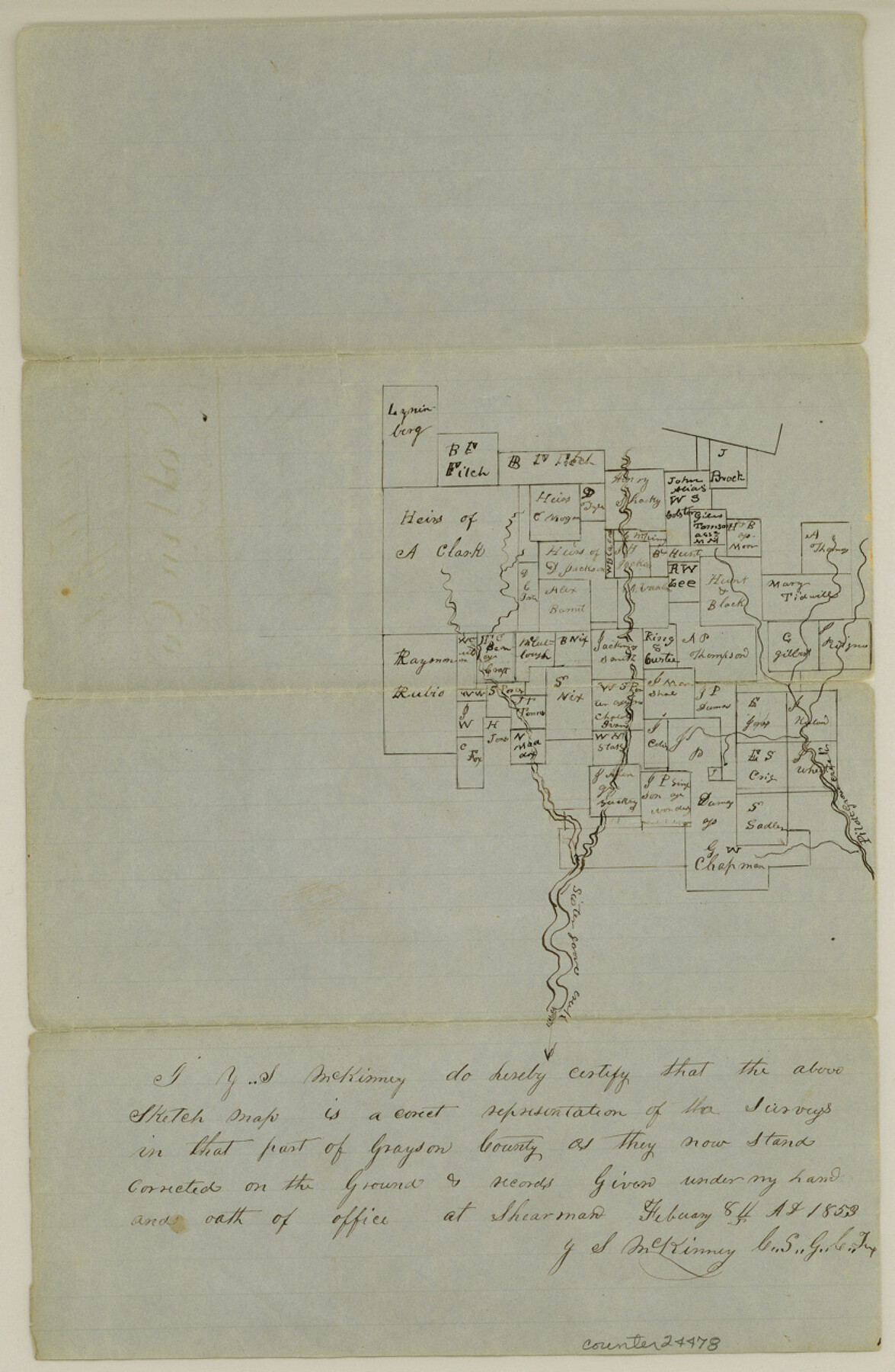
Grayson County Sketch File 12
[Sketch of surveys on Sister Grove Creek and Pilot Grove Creek]
-
Map/Doc
24478
-
Collection
General Map Collection
-
Object Dates
1853/2/8 (Creation Date)
-
People and Organizations
Y.S. McKinney (Surveyor/Engineer)
-
Counties
Grayson
-
Subjects
Surveying Sketch File
-
Height x Width
12.8 x 8.4 inches
32.5 x 21.3 cm
-
Medium
paper, manuscript
-
Features
Pilott [sic] Grove Creek
Sister Grove Creek
[Six Miles Creek]
Part of: General Map Collection
City of Corpus Christi, Texas

Print $20.00
- Digital $50.00
City of Corpus Christi, Texas
1969
Size 22.6 x 51.0 inches
Map/Doc 96520
Map of McClennan County

Print $20.00
- Digital $50.00
Map of McClennan County
1868
Size 22.8 x 25.4 inches
Map/Doc 3861
Baylor County Boundary File 14

Print $6.00
- Digital $50.00
Baylor County Boundary File 14
Size 11.1 x 8.6 inches
Map/Doc 50428
Liberty County Sketch File 5b

Print $6.00
- Digital $50.00
Liberty County Sketch File 5b
1857
Size 8.0 x 3.5 inches
Map/Doc 29890
St. L. S-W. Ry. of Texas Map of Lufkin Branch in Angelina County, Texas

Print $20.00
- Digital $50.00
St. L. S-W. Ry. of Texas Map of Lufkin Branch in Angelina County, Texas
1913
Size 24.0 x 12.1 inches
Map/Doc 64562
Webb County Rolled Sketch 46

Print $20.00
- Digital $50.00
Webb County Rolled Sketch 46
1942
Size 28.2 x 26.9 inches
Map/Doc 8201
Liberty County Rolled Sketch D

Print $42.00
- Digital $50.00
Liberty County Rolled Sketch D
1942
Size 28.4 x 30.1 inches
Map/Doc 9572
Dickens County Working Sketch 1

Print $20.00
- Digital $50.00
Dickens County Working Sketch 1
Size 15.5 x 15.5 inches
Map/Doc 68648
Live Oak County Working Sketch 3

Print $20.00
- Digital $50.00
Live Oak County Working Sketch 3
1910
Size 21.5 x 19.0 inches
Map/Doc 70588
Galveston County NRC Article 33.136 Sketch 18

Print $66.00
- Digital $50.00
Galveston County NRC Article 33.136 Sketch 18
2003
Size 22.4 x 33.9 inches
Map/Doc 78545
Blanco County Sketch File 25

Print $40.00
- Digital $50.00
Blanco County Sketch File 25
1888
Size 17.1 x 14.2 inches
Map/Doc 14616
Presidio County Working Sketch 73

Print $20.00
- Digital $50.00
Presidio County Working Sketch 73
1962
Size 17.7 x 29.4 inches
Map/Doc 71750
You may also like
Collingsworth County Sketch File 8

Print $4.00
- Digital $50.00
Collingsworth County Sketch File 8
Size 7.4 x 11.6 inches
Map/Doc 18889
Nueces County Sketch File 78

Print $72.00
- Digital $50.00
Nueces County Sketch File 78
1996
Size 11.1 x 8.4 inches
Map/Doc 33060
Angelina County Working Sketch 2

Print $20.00
- Digital $50.00
Angelina County Working Sketch 2
1899
Size 18.3 x 23.4 inches
Map/Doc 67082
Kinney County Boundary File 1

Print $94.00
- Digital $50.00
Kinney County Boundary File 1
Size 20.3 x 3.7 inches
Map/Doc 64935
Lubbock County Working Sketch 6

Print $20.00
- Digital $50.00
Lubbock County Working Sketch 6
1959
Size 25.1 x 22.4 inches
Map/Doc 70666
Jefferson County Rolled Sketch 25B

Print $20.00
- Digital $50.00
Jefferson County Rolled Sketch 25B
Size 23.2 x 28.3 inches
Map/Doc 6390
Bandera County Working Sketch 47

Print $20.00
- Digital $50.00
Bandera County Working Sketch 47
1981
Size 19.6 x 12.0 inches
Map/Doc 67643
Flight Mission No. DCL-7C, Frame 140, Kenedy County

Print $20.00
- Digital $50.00
Flight Mission No. DCL-7C, Frame 140, Kenedy County
1943
Size 18.6 x 22.2 inches
Map/Doc 86097
Duval County Sketch File 22

Print $20.00
- Digital $50.00
Duval County Sketch File 22
1880
Size 31.9 x 23.2 inches
Map/Doc 11386
Terrell County Working Sketch 8a

Print $20.00
- Digital $50.00
Terrell County Working Sketch 8a
1917
Size 14.5 x 19.4 inches
Map/Doc 62157
Dickens County, Texas

Print $20.00
- Digital $50.00
Dickens County, Texas
Size 33.7 x 39.8 inches
Map/Doc 92588
Austin County Boundary File 4

Print $10.00
- Digital $50.00
Austin County Boundary File 4
Size 14.1 x 8.6 inches
Map/Doc 50244