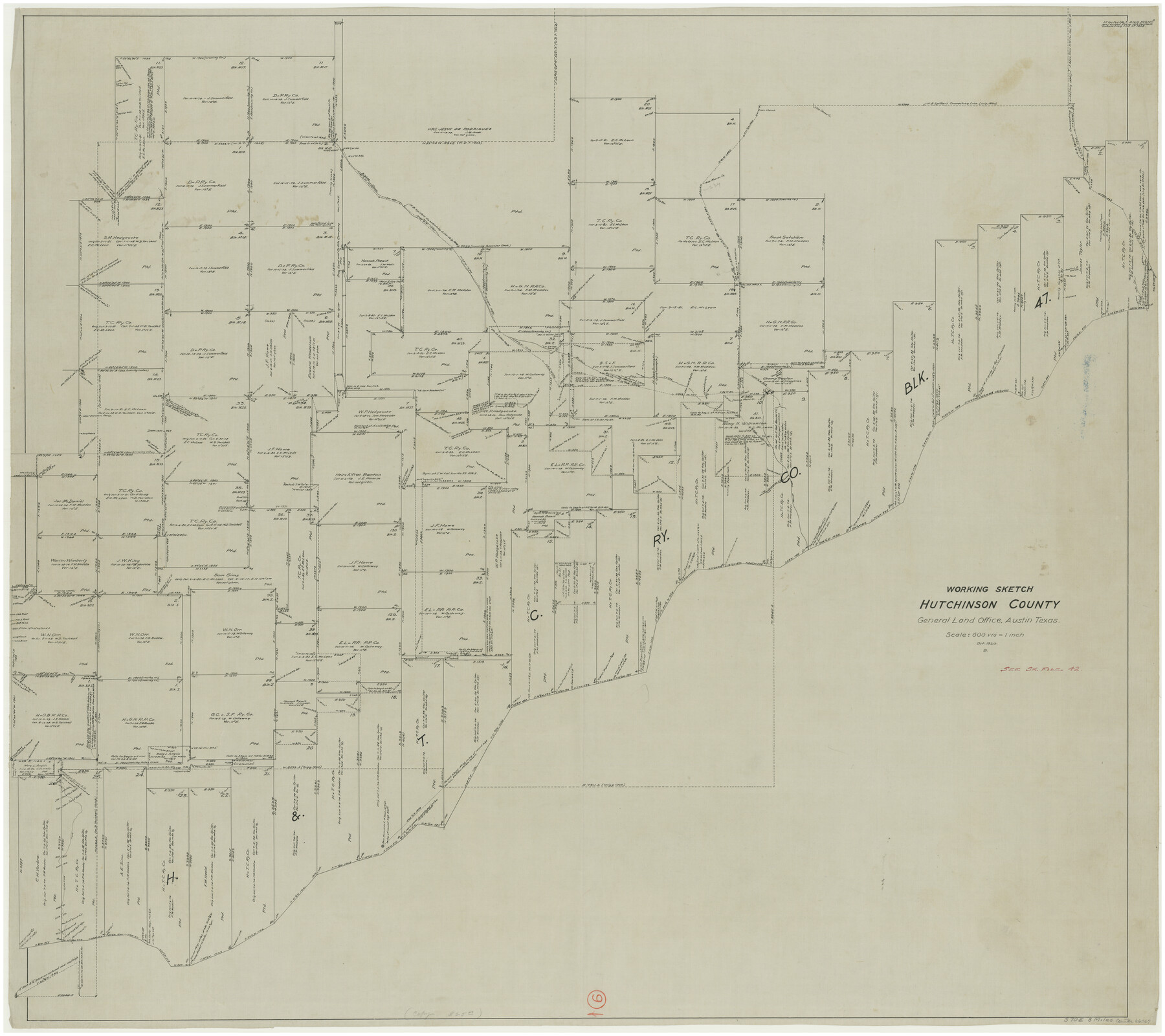
Hutchinson County Working Sketch 9
-
Map/Doc
66367
-
Collection
General Map Collection
-
Object Dates
10/1920 (Creation Date)
-
Counties
Hutchinson
-
Subjects
Surveying Working Sketch
-
Height x Width
38.5 x 43.3 inches
97.8 x 110.0 cm
-
Scale
1" = 600 varas
-
Comments
See Hutchinson County Sketch File 42 (27305) for related correspondence.
Related maps
Hutchinson County Sketch File 42

Print $9.00
- Digital $50.00
Hutchinson County Sketch File 42
1920
Size 14.3 x 8.9 inches
Map/Doc 27305
Part of: General Map Collection
Blanco County Rolled Sketch 23

Print $20.00
- Digital $50.00
Blanco County Rolled Sketch 23
2019
Size 24.1 x 35.7 inches
Map/Doc 97346
Archer County Working Sketch 8

Print $20.00
- Digital $50.00
Archer County Working Sketch 8
1921
Size 18.3 x 19.3 inches
Map/Doc 67148
Donley County Working Sketch 5

Print $40.00
- Digital $50.00
Donley County Working Sketch 5
1957
Size 54.8 x 32.2 inches
Map/Doc 62185
![94160, Austin and Vicinity [Recto], General Map Collection](https://historictexasmaps.com/wmedia_w700/maps/94160.tif.jpg)
Shelby County Working Sketch 23a

Print $20.00
- Digital $50.00
Shelby County Working Sketch 23a
1983
Size 28.1 x 31.0 inches
Map/Doc 63876
Brazoria County NRC Article 33.136 Sketch 25

Print $134.00
Brazoria County NRC Article 33.136 Sketch 25
2025
Map/Doc 97440
Polk County Working Sketch 37

Print $20.00
- Digital $50.00
Polk County Working Sketch 37
1974
Size 31.3 x 38.2 inches
Map/Doc 71654
2008 Official Travel Map, Texas

2008 Official Travel Map, Texas
Size 33.4 x 36.5 inches
Map/Doc 94343
Orange County Working Sketch 47

Print $20.00
- Digital $50.00
Orange County Working Sketch 47
1987
Size 27.5 x 26.5 inches
Map/Doc 71379
Brazoria County State Real Property Sketch 2

Print $60.00
- Digital $50.00
Brazoria County State Real Property Sketch 2
2003
Size 31.0 x 42.9 inches
Map/Doc 83356
Flight Mission No. CRE-2R, Frame 167, Jackson County

Print $20.00
- Digital $50.00
Flight Mission No. CRE-2R, Frame 167, Jackson County
1956
Size 18.6 x 22.4 inches
Map/Doc 85377
Bexar County Sketch File 26

Print $4.00
- Digital $50.00
Bexar County Sketch File 26
1860
Size 8.6 x 10.8 inches
Map/Doc 14488
You may also like
Map of Texas to accompany "Brady's Glimpses of Texas"

Print $20.00
- Digital $50.00
Map of Texas to accompany "Brady's Glimpses of Texas"
1871
Size 13.0 x 16.1 inches
Map/Doc 93907
Brewster County Rolled Sketch 49A

Print $20.00
- Digital $50.00
Brewster County Rolled Sketch 49A
1930
Size 23.5 x 29.6 inches
Map/Doc 5224
Hardin County Working Sketch 29

Print $20.00
- Digital $50.00
Hardin County Working Sketch 29
1958
Size 36.7 x 22.1 inches
Map/Doc 63427
Flight Mission No. BRA-16M, Frame 181, Jefferson County

Print $20.00
- Digital $50.00
Flight Mission No. BRA-16M, Frame 181, Jefferson County
1953
Size 18.6 x 22.2 inches
Map/Doc 85779
Working Sketch from Fisher County [around Roby]
![90911, Working Sketch from Fisher County [around Roby], Twichell Survey Records](https://historictexasmaps.com/wmedia_w700/maps/90911-1.tif.jpg)
Print $20.00
- Digital $50.00
Working Sketch from Fisher County [around Roby]
1901
Size 22.7 x 31.1 inches
Map/Doc 90911
Burleson County Working Sketch 17

Print $20.00
- Digital $50.00
Burleson County Working Sketch 17
1980
Size 20.5 x 37.6 inches
Map/Doc 67736
Wichita County Sketch File 25

Print $20.00
- Digital $50.00
Wichita County Sketch File 25
1919
Size 17.6 x 22.3 inches
Map/Doc 12685
Wheeler County Working Sketch 3

Print $40.00
- Digital $50.00
Wheeler County Working Sketch 3
1972
Size 73.8 x 43.7 inches
Map/Doc 72492
Map of McClennan County

Print $20.00
- Digital $50.00
Map of McClennan County
1855
Size 22.7 x 24.7 inches
Map/Doc 3860
Llano County Working Sketch 2

Print $20.00
- Digital $50.00
Llano County Working Sketch 2
1949
Size 21.0 x 24.3 inches
Map/Doc 70620
[Southeast Corner of Glasscock County]
![90786, [Southeast Corner of Glasscock County], Twichell Survey Records](https://historictexasmaps.com/wmedia_w700/maps/90786-1.tif.jpg)
Print $20.00
- Digital $50.00
[Southeast Corner of Glasscock County]
Size 19.2 x 22.5 inches
Map/Doc 90786
[Part of Block GG]
![90314, [Part of Block GG], Twichell Survey Records](https://historictexasmaps.com/wmedia_w700/maps/90314-1.tif.jpg)
Print $20.00
- Digital $50.00
[Part of Block GG]
Size 15.2 x 21.5 inches
Map/Doc 90314