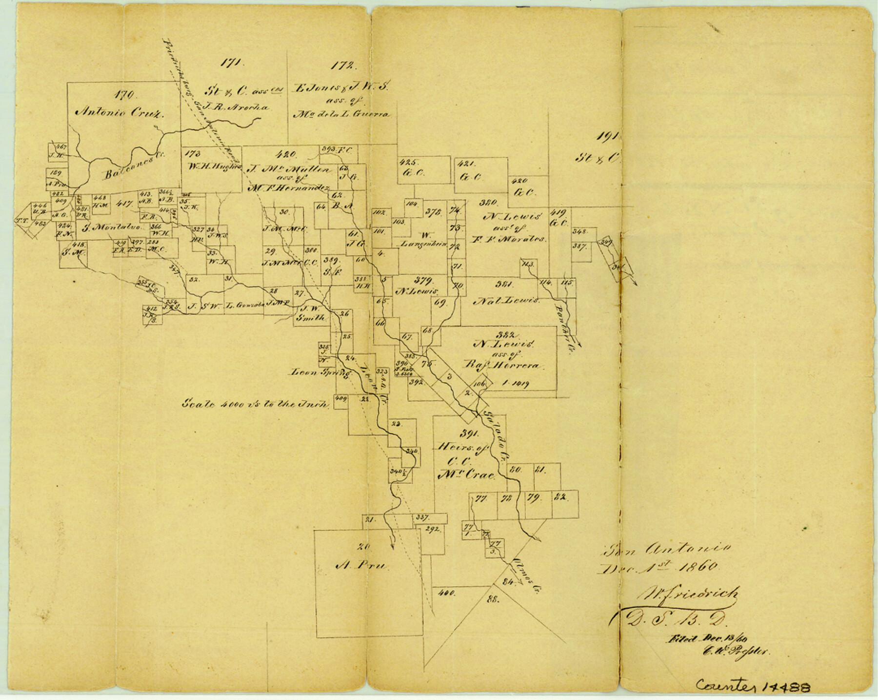
Bexar County Sketch File 26
[Sketch of surveys northwest of San Antonio near Leon, Salado, and Panther Creeks]
- 
                          Map/Doc
14488
 - 
                            Collection
General Map Collection
 - 
                            Object Dates
1860/12/1 (Creation Date)
1860/12/13 (File Date)
 - 
                            People and Organizations
W. Friedrich (Surveyor/Engineer)
 - 
                            Counties
Bexar
 - 
                            Subjects
Surveying Sketch File
 - 
                            Height x Width
8.6 x 10.8 inches
21.8 x 27.4 cm
 - 
                            Medium
paper, manuscript
 - 
                            Scale
1" = 4000 varas
 - 
                            Features
Fredericksburg-San Antonio Road
Fredericksburg Road
San Antonio Road
Balcones Creek
Panther Creek
Salado Creek
Leon Spring
Olmos Creek
 
Part of: General Map Collection
            Official Map of the City of Bryan from Actual Survey [East half]


                                            Print $40.00                    
                                             -                         Digital $50.00                                    
                Official Map of the City of Bryan from Actual Survey [East half]
1898
Size 52.3 x 27.4 inches
                                Map/Doc 3203
            
            [Sketch for Mineral Application 16700 - Pecos River Bed]


                                            Print $20.00                    
                                             -                         Digital $50.00                                    
                [Sketch for Mineral Application 16700 - Pecos River Bed]
1927
Size 32.9 x 15.3 inches
                                Map/Doc 2807
            
            Galveston County Sketch File 38


                                            Print $8.00                    
                                             -                         Digital $50.00                                    
                Galveston County Sketch File 38
1908
Size 6.8 x 7.8 inches
                                Map/Doc 23441
            
            Terrell County Working Sketch 33


                                            Print $20.00                    
                                             -                         Digital $50.00                                    
                Terrell County Working Sketch 33
1945
Size 16.1 x 31.6 inches
                                Map/Doc 62125
            
            San Jacinto County Sketch File 1


                                            Print $22.00                    
                                    
                San Jacinto County Sketch File 1
1852
Size 7.9 x 12.4 inches
                                Map/Doc 35694
            
            [Surveys in Austin's Colony along the San Antonio Road and the Colorado River]


                                            Print $20.00                    
                                             -                         Digital $50.00                                    
                [Surveys in Austin's Colony along the San Antonio Road and the Colorado River]
1821
Size 17.3 x 25.6 inches
                                Map/Doc 15
            
            DeWitt County Working Sketch 9


                                            Print $20.00                    
                                             -                         Digital $50.00                                    
                DeWitt County Working Sketch 9
1979
Size 15.7 x 23.4 inches
                                Map/Doc 68599
            
            Jeff Davis County Rolled Sketch 5


                                            Print $40.00                    
                                             -                         Digital $50.00                                    
                Jeff Davis County Rolled Sketch 5
Size 34.7 x 48.6 inches
                                Map/Doc 9262
            
            Live Oak County Rolled Sketch 3


                                            Print $20.00                    
                                             -                         Digital $50.00                                    
                Live Oak County Rolled Sketch 3
1944
Size 31.2 x 47.2 inches
                                Map/Doc 10630
            
            Flight Mission No. DIX-10P, Frame 75, Aransas County


                                            Print $20.00                    
                                             -                         Digital $50.00                                    
                Flight Mission No. DIX-10P, Frame 75, Aransas County
1956
Size 18.6 x 22.3 inches
                                Map/Doc 83936
            
            Presidio County Sketch File 37A


                                            Print $18.00                    
                                             -                         Digital $50.00                                    
                Presidio County Sketch File 37A
Size 11.4 x 8.8 inches
                                Map/Doc 34499
            
            Randall County Sketch File 8


                                            Print $20.00                    
                                             -                         Digital $50.00                                    
                Randall County Sketch File 8
Size 18.1 x 23.1 inches
                                Map/Doc 12209
            You may also like
            Denton County Sketch File AB


                                            Print $8.00                    
                                             -                         Digital $50.00                                    
                Denton County Sketch File AB
1896
Size 7.8 x 6.9 inches
                                Map/Doc 20677
            
            [Sketch showing parts of  Blocks 3, 5, 22, M-20, S, T and Block BB, surveys 1, 2 and 3]


                                            Print $20.00                    
                                             -                         Digital $50.00                                    
                [Sketch showing parts of Blocks 3, 5, 22, M-20, S, T and Block BB, surveys 1, 2 and 3]
Size 15.5 x 15.9 inches
                                Map/Doc 91730
            
            Howard County Working Sketch 7b


                                            Print $40.00                    
                                             -                         Digital $50.00                                    
                Howard County Working Sketch 7b
1950
Size 83.3 x 25.6 inches
                                Map/Doc 66274
            
            Travis County


                                            Print $40.00                    
                                             -                         Digital $50.00                                    
                Travis County
1936
Size 45.6 x 55.8 inches
                                Map/Doc 63077
            
            Hale County Sketch File 23


                                            Print $4.00                    
                                             -                         Digital $50.00                                    
                Hale County Sketch File 23
1903
Size 11.2 x 8.5 inches
                                Map/Doc 24759
            
            Karnes County Working Sketch 10


                                            Print $20.00                    
                                             -                         Digital $50.00                                    
                Karnes County Working Sketch 10
1970
Size 35.5 x 26.3 inches
                                Map/Doc 66658
            
            Shelby County Working Sketch 9


                                            Print $20.00                    
                                             -                         Digital $50.00                                    
                Shelby County Working Sketch 9
1945
Size 30.8 x 28.5 inches
                                Map/Doc 63862
            
            Polk County Sketch File 10


                                            Print $4.00                    
                                             -                         Digital $50.00                                    
                Polk County Sketch File 10
Size 5.2 x 6.4 inches
                                Map/Doc 34140
            
            Zapata County Working Sketch 11


                                            Print $20.00                    
                                             -                         Digital $50.00                                    
                Zapata County Working Sketch 11
1958
Size 38.1 x 28.7 inches
                                Map/Doc 62062
            
            Haskell County Boundary File 1


                                            Print $36.00                    
                                             -                         Digital $50.00                                    
                Haskell County Boundary File 1
Size 8.7 x 9.0 inches
                                Map/Doc 54518
            
            Flight Mission No. CRE-1R, Frame 194, Jackson County


                                            Print $20.00                    
                                             -                         Digital $50.00                                    
                Flight Mission No. CRE-1R, Frame 194, Jackson County
1956
Size 18.5 x 22.3 inches
                                Map/Doc 85348